

Dec 14: Winter Storm Developing
Discussion: Today’s weaker event is now ending and we can focus exclusively on the higher-impacts of the Wednesday-Thursday system. Not much has changed in the model guidance. We have a surface low tracking in over the coastal Carolinas and wanting to track N. However, it encounters a strong block to the N via high pressure and 50/50 low created from today’s system. Therefore it then jets E. How close the low tucks towards the Atlantic City area will determine the precise snow/rain line profile through SNJ/SENJ and ultimately where the KABOOM jackpot axis sets up further to the NW. Let’s break the system down by weather safety hazard:
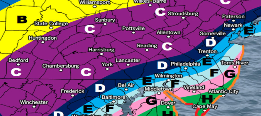
Wintry Precipitation – The model guidance has been locked in on NNJ seeing the most amount of snow from this winter storm. NNJ is expected to be in the coldest area of heaviest precipitation. For this reason, everyone NW of 95 should KABOOM with 12 inches of snow or greater with little-to-no mixing. Along 95 and just to the SE of 95 is a much harder call. There’s likely going to be a tight thermal gradient and razor sharp snow rain line for the first half of the event. There’s a lot of uncertainty as to where that sharp cutoff will hold. Eventually all areas should change to snow for the second half of system. SWNJ and interior SNJ/ECNJ would changeover first and likely still see a plowable snowfall to end. SENJ would changeover last and therefore see the most amount of front-end rain and least amount of ending snow. I think 95 and points SE could deal with some icing, especially sleet briefly between rain changing to snow. The following impact map represents our best physics-based prediction for Wednesday-Thursday based on all model guidance and live observations upstream:
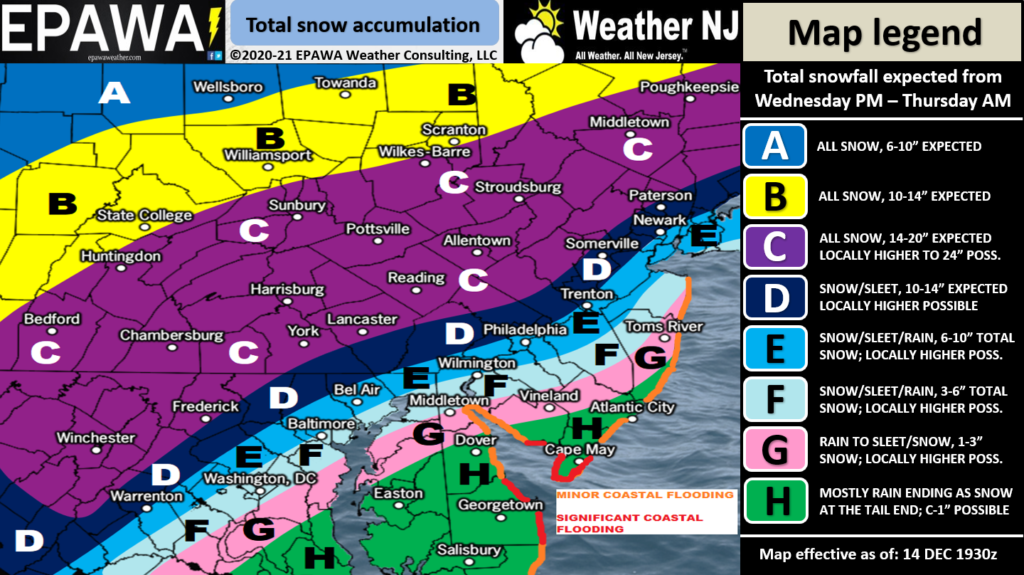
Please click here for full resolution snow map!
The wildcards of cold air aloft and heavy precipitation should be mentioned. This is what would make zones E and F behave more like D and bump zones G and H (away from the ocean) slightly higher. We’re likely going to have significant frontogenesis rates (precipitation creation) which could fall heavy enough to bring colder air aloft to the ground. It’s going to be below freezing at 925mb and up in altitude. Only the lower levels will be warmed by the ocean. Therefore it wouldn’t take much to crash out the surface to freezing further to the SE. The dynamics should be convective and complex. Wildcards in the other direction include the 700-850mb levels warming temporarily over SE PA and convective dry slotting. This could mean either some precipitation falling as sleet instead of snow or areas of dry sinking air inhibiting accumulations and precipitation. This would ultimately produce a lower outcome of snow accumulations. We’re hesitant to factor these wildcards into the map and prediction but want to mention the possibility as far as what can go wrong with the forecast.
Wind – The low pressure system is not modeled that strong. It barely drops below 1000mb of intensity. It is however modeled to delivery its strongest wind gusts into SENJ/ECNJ between Wednesday and Thursday. The high pressure and low pressure positioning will be perfectly aligned for a strong onshore fetch. The tight pressure gradient running parallel to the wind direction tells me strong E/SE to E/NE wind gusts are possible for the ocean-facing coasts of SENJ/ECNJ. 60mph kind of stuff during peak intensity. Lesser values as you head inland but still windy, possibly enough to meet blizzard conditions further NW in NJ where it should be snowing hard. I would expect widespread wind-related power outages during this event.
Coastal Flooding – At the very least we’re looking at a storm surge capable of at least minor coastal flooding along the entire ocean-facing Jersey shore. This would include beaches, bays, and back-draining creeks in the immediate coastal areas of SENJ/ECNJ. The flooding risk appears higher, per tidal guidance, further S near Cape May, NJ and Lewes, DE. Periods of heavy rainfall SE of the snow rain line could also contribute to flash flooding and poor drainage issues.
In English: A decent coastal winter storm is approaching. It should impact much of NJ between Wednesday and Thursday. First part of system has NJ divided (near I-95/NJTP) with snow/rain for much of Wednesday. Second part rain changes to snow for all areas through Thursday morning. Please see the above impact map for expected wintry accumulations. High winds especially for the SENJ/ECNJ coast which is why coastal flooding and power outages are very much on the table for Wednesday PM int Thursday AM. One final update tomorrow so still time to tweak the forecast slightly. But the coastal winter storm is coming. Have a great night and please be safe! JC
Download the free Weather NJ mobile app on Apple or Android. It’s the easiest way to never miss Weather NJ content. Our premium services go even further above and beyond at the hyper-local level. Get your merch on at the KABOOM shop in time for the holidays.
Jonathan Carr (JC) is the founder and sole operator of Weather NJ, New Jersey’s largest independent weather reporting agency. Since 2010, Jonathan has provided weather safety discussion and forecasting services for New Jersey and surrounding areas through the web and social media. Originally branded as Severe NJ Weather (before 2014), Weather NJ is proud to bring you accurate and responsible forecast discussion ahead of high-stakes weather scenarios that impact this great garden state of ours. All Weather. All New Jersey.™ Be safe! JC


LOCAL FORECAST | INTERACTIVE RADAR | LATEST NJ WEATHER ALERTS | WEDDING FORECAST| PRIVACY POLICY
© Copyright 2026 Weather NJ LLC. All Rights Reserved.
Some information that can be found on our website is provided by a private weather station and is not an officially recognized station for weather reporting. Though we always strive to achieve accurate reporting for our own use, it is important that you do NOT depend on the data provided here for any purpose.
