

Dec 15: Light Wintry Event Update
Discussion: This system is far from a big snowstorm and whatever wintry action occurs changes over to rain. So if you’re looking for lasting snow accumulations from it you should just move along. However since the initial precipitation and transition from it could fall as either snow, sleet or freezing rain during Monday PM rush hour we have to cover the safety hazards appropriately.
First let’s talk about the cold source. Our early-weekend rainy system has moved out and now we have W/NW flow aloft. It is much colder aloft right now than at the surface. Overnight tonight (after sundown) the cold will propagate to the surface and take us all down to near-freezing values by sunrise Monday. A weak wave of low pressure should then track from TN/KY straight through SNJ and out to sea between tomorrow (Monday) and Tuesday. Precipitation could arrive as early as 9am Monday as surface temperatures begin to rise above freezing. It will be a quicker rise above freezing for the lower 2/3 of New Jersey than it will be for the northern 1/3 (elevations). With that said precipitation should start as snow on Monday for many areas with struggling accumulations. Snow should change to ice (either sleet or freezing rain) and then plain rain from S to N throughout Monday afternoon-evening. Most guidance is suggesting a light-to-moderate ice event during the transition. The Euro however suggests a crippling ice event but it is an outlier. In either case ice is bad for travel so expect a bad ice event but hope for a light ice event. Most importantly use caution.
Then from Monday evening through Tuesday morning should be all rain for most of New Jersey. We have to allow only the higher elevations of Sussex County, and surrounding areas, to remain icy throughout the entire event. If you are along or S of I-80 and/or SE of I-287 you’re likely going over to plain rain.
We’re talking about just a little bit of front end snow (NWNJ favored) to possibly a solid icing event (NNJ and WCNJ favored) to rain (except for highest NWNJ/NNJ elevations). The most dangerous safety hazard should be ice during the Monday PM rush hour and for areas NW of I-95/NJTP. The following maps represent our most recent expectations for snow (top) and ice (bottom):
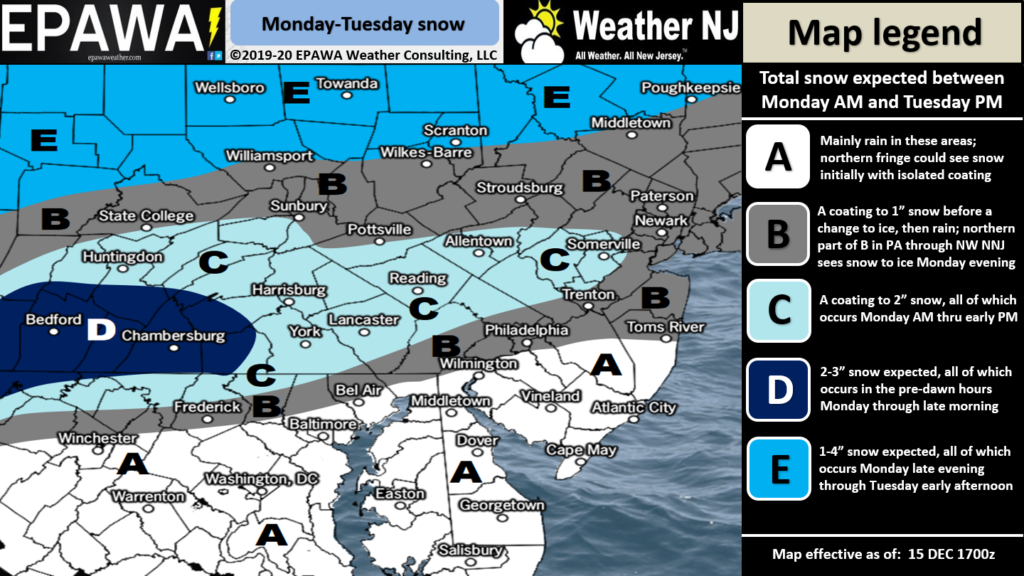
Click here to view full-resolution map!
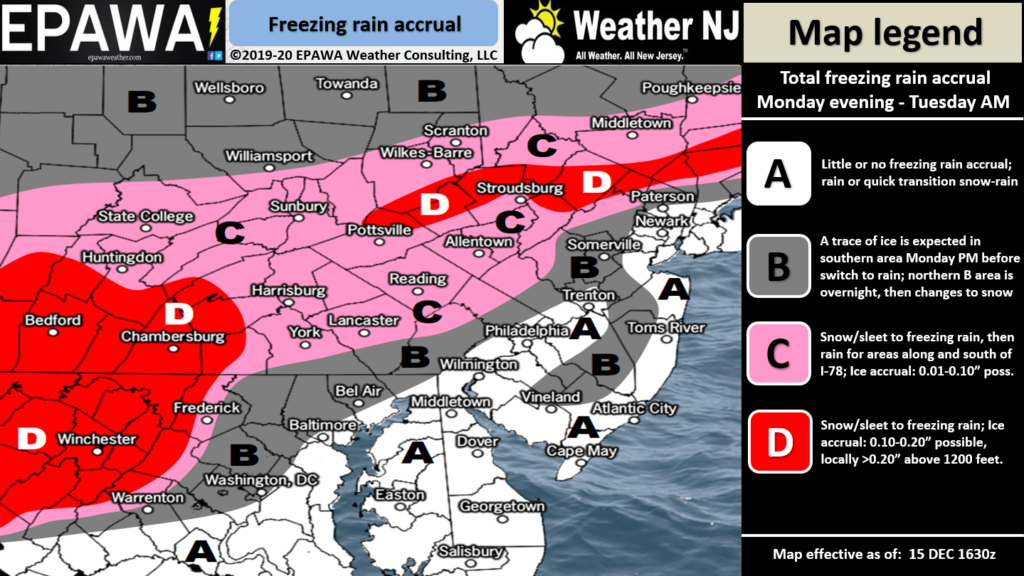
Click here to view full-resolution map!
I am still watching the December 22-23 synoptic storm signal. Models are all over the place but they agree on a strong low pressure system impacting somewhere along the east coast. Once this more immediate system moves out completely (by Wednesday) we should have a better idea and can begin tracking seriously. One thing I AM seeing with confidence is an aggressive drop in temperatures behind this Monday-Tuesday system. A gradual drop in temperatures Tuesday night into Wednesday and then a “Baby it’s cold outside” drop Wednesday overnight into Thursday.
In English: Precipitation arrives by late Monday morning. A quick changeover from snow to rain for most of SNJ. NNJ and CNJ is a bit more complicated with an icy transition involved between late Monday morning and Monday afternoon/early evening. The ice storm aspect is by far the most dangerous safety hazard of the entire system. By Monday evening all areas of New Jersey should be over to plain rain aside from the higher elevations of NNJ/NWNJ (N of I-80 and NW of I-287). Such areas might even remain icy through Tuesday morning when precipitation ends. Please use a little extra caution and allow some more time for your Monday PM travel. The western areas of I-80 through NJ could be in bad shape. For most along and SE of the turnpike this event is just a rainy nuisance that could start with conversational non-accumulating precipitation. Have a great rest of your Sunday and please be safe! JC
Download the new free Weather NJ mobile app on Apple and/or Android. It’s the easiest way to never miss Weather NJ content. Our premium services go even further above and beyond at the hyper-local level. Looking for industrial-caliber long-range forecasting data that I personally recommend? Check out WeatherTrends360! Visit the Weather NJ Kaboom Shop for hoodies, tees and infant onesies.
Jonathan Carr (JC) is the founder and sole operator of Weather NJ, New Jersey’s largest independent weather reporting agency. Since 2010, Jonathan has provided weather safety discussion and forecasting services for New Jersey and surrounding areas through the web and social media. Originally branded as Severe NJ Weather (before 2014), Weather NJ is proud to bring you accurate and responsible forecast discussion ahead of high-stakes weather scenarios that impact this great garden state of ours. All Weather. All New Jersey.™ Be safe! JC


LOCAL FORECAST | INTERACTIVE RADAR | LATEST NJ WEATHER ALERTS | WEDDING FORECAST| PRIVACY POLICY
© Copyright 2026 Weather NJ LLC. All Rights Reserved.
Some information that can be found on our website is provided by a private weather station and is not an officially recognized station for weather reporting. Though we always strive to achieve accurate reporting for our own use, it is important that you do NOT depend on the data provided here for any purpose.
