

Dec 15: Updated Impact Maps for Saturday Morning
We’ve moved from a probability-based map to two separate maps, one for snow and the other for ice. Our final map will be issued tomorrow based on live observations and short-range guidance but this is how we feel now…
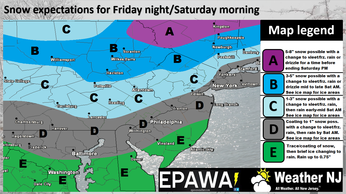
Click here to view full resolution snow map.
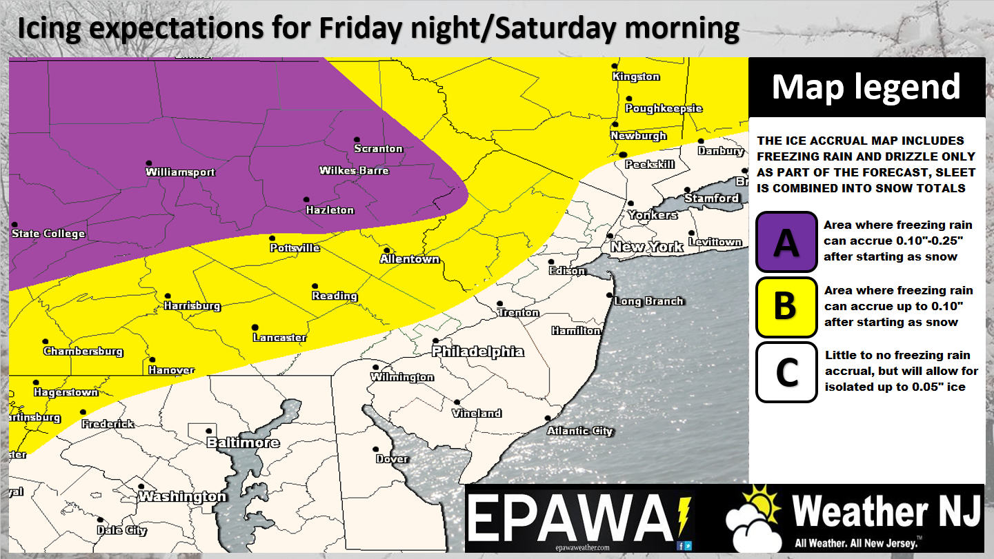
Click here to view full resolution ice map.
So that no one is let down, let me remind everyone that this is a snow to ice to rain event. As in…everyone should eventually transition to rain, even extreme NNJ. With that said, anyone who sleeps-in on Saturday could wake up, look out the window and say “What snow? or What ice?”
This is because the wintry concern will happen in the late-Friday night/early Saturday AM period while most are sleeping. However, those who need to travel/etc. between about 10PM Friday night and 7AM Saturday morning need to take this seriously. It takes a few inches of snow to disrupt travel however it only takes a razor-thin sheet of ice to do the same. So for the period of transition that will occur during the early AM hours of Saturday morning, please use caution.
The biggest trend we’ve seen on model guidance is the reduction of moisture. Temperatures are still cold but the reduction in moisture would make this initial wintry-thump slightly less potent. It is still very much expected to create problems but accumulating snow is looking like lesser of a headline. Ice is probably my main concern and as indicated above in the map, is a higher concern for those NW of the I-95 corridor.
In English: This is our second call. The final call will be issued tomorrow as we continue to tweak. Winds should relax overnight tonight but expect the cold to persist until early Saturday AM. That’s when precipitation is expected to initially move in from the west in the form of snow. Warmer southerly winds will then quickly change the lower 2/3 of NJ over to a brief period of ice (sleet and/or freezing rain) before becoming all rain (by 8am). The northern 1/3 of NJ, especially NWNJ are subject to the greatest snow accumulations and ice accrual before also eventually going to rain (by late-Saturday morning). Saturday afternoon through Sunday then looks milder with on-and-off rain with a small chance of rain ending as snow Sunday afternoon-evening. Everyone stay warm, have a great night and please be safe! JC
s
Jonathan Carr (JC) is the founder and sole operator of Weather NJ, New Jersey’s largest independent weather reporting agency. Since 2010, Jonathan has provided weather safety discussion and forecasting services for New Jersey and surrounding areas through the web and social media. Originally branded as Severe NJ Weather (before 2014), Weather NJ is proud to bring you accurate and responsible forecast discussion ahead of high-stakes weather scenarios that impact this great garden state of ours. All Weather. All New Jersey.™ Be safe! JC


LOCAL FORECAST | INTERACTIVE RADAR | LATEST NJ WEATHER ALERTS | WEDDING FORECAST| PRIVACY POLICY
© Copyright 2026 Weather NJ LLC. All Rights Reserved.
Some information that can be found on our website is provided by a private weather station and is not an officially recognized station for weather reporting. Though we always strive to achieve accurate reporting for our own use, it is important that you do NOT depend on the data provided here for any purpose.
