

Dec 15: Wintry Sunday Possible for NNJ
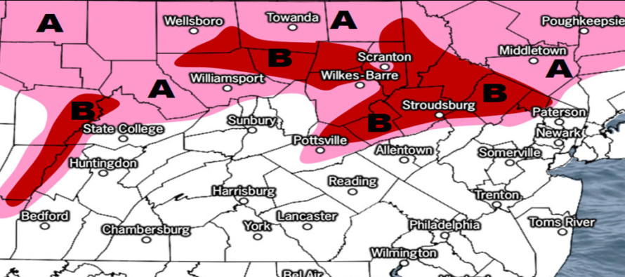

Discussion: As low pressure slides by to our S (from W to E) high pressure is sliding by to our N (also from W to E). The low is drawing up the warmer moisture while the high is pushing down the colder dry air. This is keeping most rainfall along/S of I-195 today but precipitation should spread into NNJ tonight and overnight into tomorrow. The Cold Air Dam (CAD) effect should hold NNJ surface temperatures colder during this transition while temperatures aloft warm. It looks like the surface and 700mb will be cold enough to support wintry precipitation however the 850mb layer will likely be warmed above freezing. Ultimately this could mean wintry precipitation hazard, primarily in the form of freezing rain but also possibly sleet and some snow, for extreme NNJ. We’re talking about N Warren, Sussex, N Morris, N Passaic and possibly extreme N Bergen Counties.
It’s a very complex atmospheric stack. It makes the most sense that freezing rain would be the primary form of wintry precipitation but sleet and even some snow are possible if the CAD were to hold more of the lower levels colder. With that said you should simply expect some form of wintry precipitation to impact areas of concern between early Sunday AM and late Sunday PM. Therefore this currently looks like a salting event rather than a plowable event for those who operate the trucks.
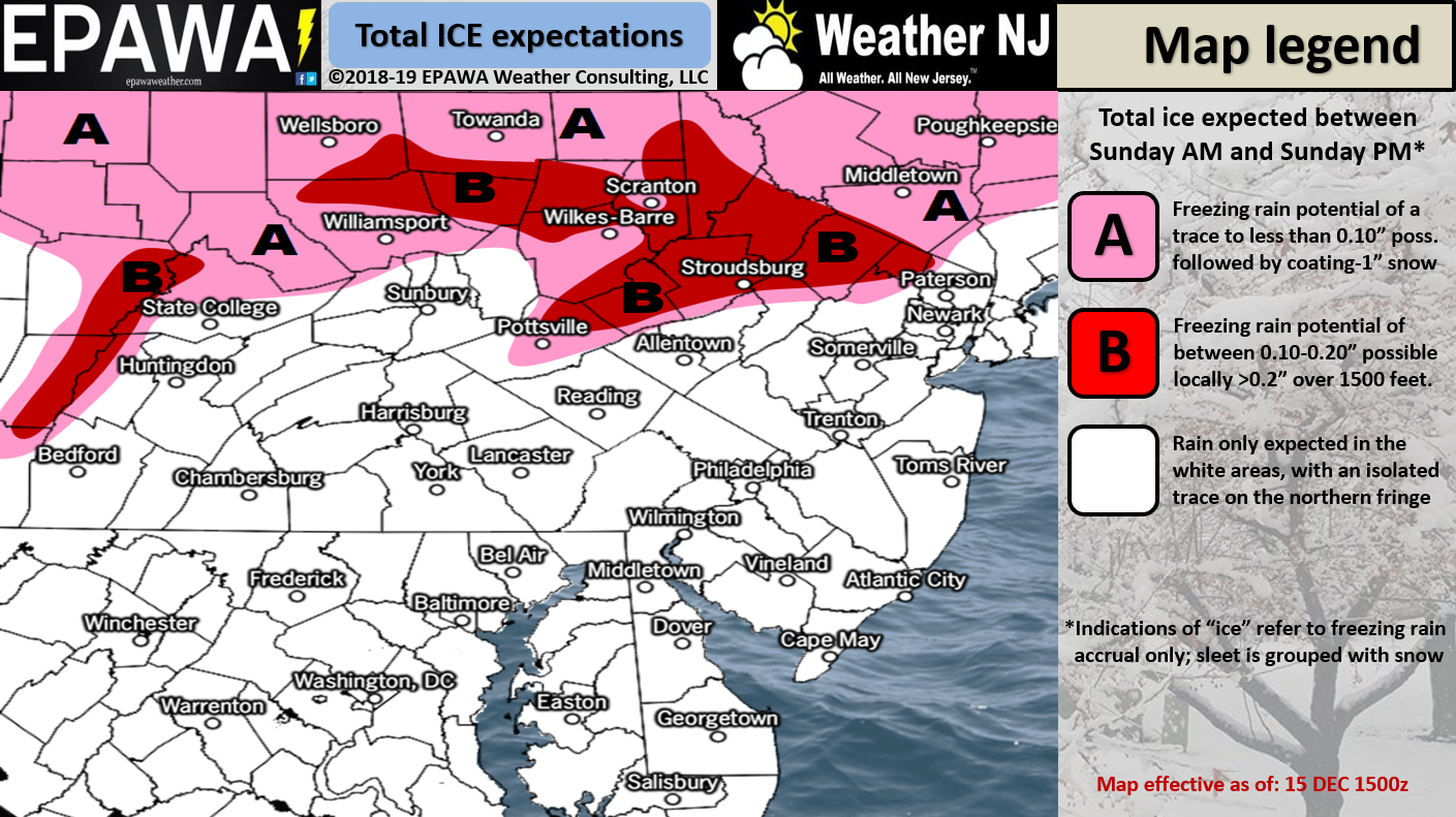
Please click here for full-resolution map!
In English: Rainfall should spread from SNJ to NNJ later this evening and into tomorrow. Extreme NNJ (see map above) has a chance to see precipitation end as freezing rain, sleet and/or snow between Sunday AM and Sunday PM. I am currently leaning towards freezing rain but let’s allow for all forms of wintry precip just in case. Everything should wrap up overnight heading into Monday with a strong cold front expected to pass through Monday evening. That should produce a cold Monday and Tuesday night before we moderate back to milder temps Wed-forward. Have a great rest of your Saturday and please be safe! JC
Jonathan Carr (JC) is the founder and sole operator of Weather NJ, New Jersey’s largest independent weather reporting agency. Since 2010, Jonathan has provided weather safety discussion and forecasting services for New Jersey and surrounding areas through the web and social media. Originally branded as Severe NJ Weather (before 2014), Weather NJ is proud to bring you accurate and responsible forecast discussion ahead of high-stakes weather scenarios that impact this great garden state of ours. All Weather. All New Jersey.™ Be safe! JC


LOCAL FORECAST | INTERACTIVE RADAR | LATEST NJ WEATHER ALERTS | WEDDING FORECAST| PRIVACY POLICY
© Copyright 2026 Weather NJ LLC. All Rights Reserved.
Some information that can be found on our website is provided by a private weather station and is not an officially recognized station for weather reporting. Though we always strive to achieve accurate reporting for our own use, it is important that you do NOT depend on the data provided here for any purpose.
