

Dec 16: Coastal Winter Storm Begins
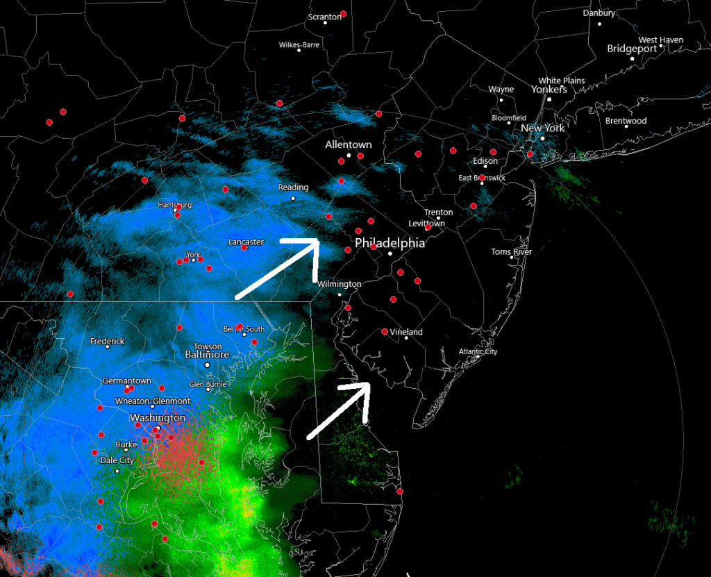
Discussion: Some radar returns are starting to show up to the SW of NJ which means precipitation, whether wintry or rain, should begin falling by early afternoon today. This is going to be the last predictive forecast article for this system. All updates after this will be in the form of real-time observations.
No new changes to the snow map. NNJ (N of I-78/NW of I-95) still gonna KABOOM with NWNJ likely the jackpot. SNJ/SENJ still looking at a rain and wind event. Those areas are confidently forecasted. The most difficult, and therefore most uncertain, forecast remains right along the I-95/NJTP corridor and about 20 miles on either side of it (mostly CNJ).
The common theme found on overnight and morning model guidance (the short-range high-res mesoscale stuff that’s in its specialty time frame right now) is a pesky warm layer located at about 750-800mb (about 7-8k feet up). The 700mb low will be tracking in a way to possibly warm sector this layer of interest (basically over and just to NW of 95/NJTP). For this reason, we have decided not to bring the KABOOM criteria snow all the way down to the 95 area. If the dynamics can override the warm layer then it is very possible that we DO see a KABOOM all the way down to 95. However for the purposes of being conservative, and in our-experience with icing during events, we’ll leave the icing language in for the highest zones of uncertainty (D and E). Basically I-95 and just NW of could go either way. Here’s is our snow map from yesterday which stands as called today heading into the system:
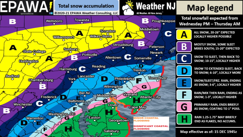
Please click here for full-resolution snow map!
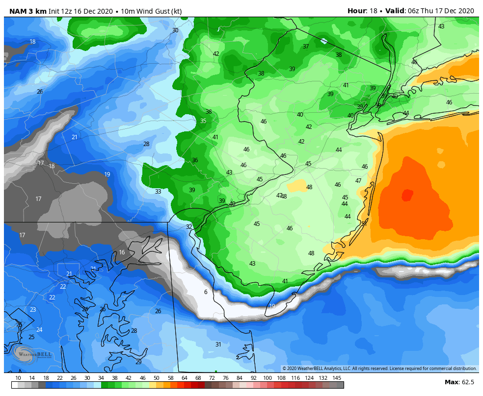
While this is a major snowstorm for NNJ, there are other aspects to discuss. If you are SE of 95 and away from the ocean, you’re probably looking at just another rain and wind event that maybe ends as trace/light snow. The biggest safety hazard for these areas would be flash flooding. If you’re right along the coast of the Atlantic Ocean, you’re going to experience the highest winds as well as coastal flooding. The highest winds of the system should occur between 8pm and 4am overnight tonight. Gusts to 65mph are possible right along the coast. All of NJ away from the coast could see gusts of 40-50mph, maybe slightly less for extreme NWNJ and extreme SWNJ. Winds should gradually subside from late Thursday morning through Thursday PM hours. This is the high-res NAM showing the period of strongest winds at 1am tonight.
As with any coastal storm or nor’easter, coastal flooding is likely between tonight and tomorrow afternoon. Two high tides occur, one late tonight and the other just before noon tomorrow. These should be the highest water levels to watch. The SNJ/SENJ rain will be draining into creeks and estuaries backed up by wind-driven storm surge. I am confident that minor levels of coastal flooding will occur with a strong chance of moderate levels. This goes for the entire Atlantic Ocean-facing coast of ECNJ/SENJ and the inner coasts that wrap around the Delaware Bay. Here’s an example tidal guidance for Sandy Hook. Much if the NJ coast will behave the same way. The blue line is what the astronomical tide will be. The gold is the expected surge. The striped black line is the predicted combo of both. Red has occurred already.
You can see the two highest tides of interest (tonight and late-morning tomorrow). You can also see that the highest wind surge period is expected to occur during low tide (around 3am Thursday). This likely saved us from a much more major coastal flooding situation if the greatest surge period were to occur during high tide. But either way there’s going to be water in the streets for places that normally get water in the streets. Prepare accordingly!
In English: Snow (for NNJ/CNJ) and rain (for SNJ) will begin falling soon (by this afternoon). The snow/rain line might start S/SE of where’s going to finally set up. But it will move N and W and eventually stop near the I-95 corridor sometime tonight. There could be a significant amount of icing (sleet and or freezing rain) between the snow and rain for the first part of this storm. The ice will then change to snow later tonight/overnight and then the snow/rain line will crash to the coast finishing everyone with at least a little bit of ending snow tomorrow morning. The above snow map represents our conservative thoughts based on the ice mixing in and lowering totals for CNJ. However, strong dynamics involved in this system could override the icing situation and bring the KABOOM down closer to 95. Thundersnow is possible folks! Otherwise high winds for everyone especially the coastal areas of ECNJ/SENJ. Minor-to-moderate coastal flooding for the same. Good luck everyone and please be safe! JC
Download the free Weather NJ mobile app on Apple or Android. It’s the easiest way to never miss Weather NJ content. Our premium services go even further above and beyond at the hyper-local level. Get your merch on at the KABOOM shop in time for the holidays.
Jonathan Carr (JC) is the founder and sole operator of Weather NJ, New Jersey’s largest independent weather reporting agency. Since 2010, Jonathan has provided weather safety discussion and forecasting services for New Jersey and surrounding areas through the web and social media. Originally branded as Severe NJ Weather (before 2014), Weather NJ is proud to bring you accurate and responsible forecast discussion ahead of high-stakes weather scenarios that impact this great garden state of ours. All Weather. All New Jersey.™ Be safe! JC


LOCAL FORECAST | INTERACTIVE RADAR | LATEST NJ WEATHER ALERTS | WEDDING FORECAST| PRIVACY POLICY
© Copyright 2025 Weather NJ LLC. All Rights Reserved.
Some information that can be found on our website is provided by a private weather station and is not an officially recognized station for weather reporting. Though we always strive to achieve accurate reporting for our own use, it is important that you do NOT depend on the data provided here for any purpose.
