

Dec 16: NNJ Winter Storm Update
Discussion: We had a little wintry precipitation move through parts of SNJ and CNJ earlier today but overall precipitation has been lighter and nothing has stuck to the “just-above freezing” surface temperatures. We’ve also had an area of weak high pressure that has helped to inhibit moisture content reaching the surface. That’s about to change.
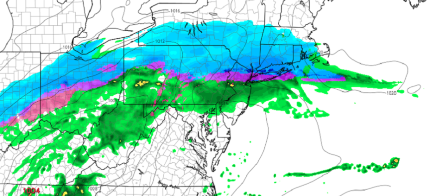
The stronger area of precipitation associated with the passing wave of low pressure should now fill into New Jersey from the W. As this happens dew points will rise and temps will drop until they meet in the middle (aka wet bulb temperature). This is setting up the following precipitation expectations from 5pm through early Tuesday morning:
NNJ (I-78 and N): A few inches of snow (let’s cap it at 2-4 in the jackpot swath) are possible before changing over to ice (either sleet or freezing rain). The snow/ice/rain line will start near I-78 near or just after rush hour and slowly work its way northward overnight. Extreme NNJ (N of I-80) might never warm to the point of rain and could see only snow to ice. This should be the most dangerous NJ region regarding slippery travel this evening through Tuesday morning. The further N you are the better the chance for more snow before changing to ice.
CNJ (between I-78 and Philly<->Toms River latitude): Only northern areas of this CNJ region will still likely battle frozen precipitation from 5pm through overnight. A snowy burst and possibly significant icing are possible here but mainly earlier in the overnight hours and in the northern area of this CNJ region (I-195 and N). Surface temps are largely just above freezing in this NJ region and therefore even if wintry precipitation falls it will likely struggle to stick especially on paved surfaces. Use caution however as it only takes a thin layer of ice to mess up your evening. The further S you are the better the chance for just cold rain with only wet slippery hazards to worry about not frozen slippery hazards.
SNJ (S of Philly<->Toms River latitude): All cold rain this evening through tomorrow morning. Roads only slipper from wet conditions not frozen conditions.
After this clears out we will dip much colder for Tuesday night through the rest of the week.
In English: The dangerous part of this system is about to start especially for areas along and N of I-78. Snow and ice should fall for said locations between this evening and Tuesday morning. For all areas S of I-78 you are likely looking at rain only. It is possible for some wintryness as far S as I-195 maybe further S earlier in the overnight hours but areas between I-195 and I-78 should go over to rain the quickest (after a few hours at most). For areas between I-80 and I-78 you are likely looking at snow to ice to rain a little slower. For areas N of I-80 you are ground zero for maximum wintry travel impact all the way through Tuesday morning…not in the form of significant snowfall but in the form of some snow to hazardous ice. 2-4 inches of snow are possible in said NNJ region under the snowiest bands before changing to ice. Please use caution and be safe! JC
Download the new free Weather NJ mobile app on Apple and/or Android. It’s the easiest way to never miss Weather NJ content. Our premium services go even further above and beyond at the hyper-local level. Looking for industrial-caliber long-range forecasting data that I personally recommend? Check out WeatherTrends360! Visit the Weather NJ Kaboom Shop for hoodies, tees and infant onesies.
Jonathan Carr (JC) is the founder and sole operator of Weather NJ, New Jersey’s largest independent weather reporting agency. Since 2010, Jonathan has provided weather safety discussion and forecasting services for New Jersey and surrounding areas through the web and social media. Originally branded as Severe NJ Weather (before 2014), Weather NJ is proud to bring you accurate and responsible forecast discussion ahead of high-stakes weather scenarios that impact this great garden state of ours. All Weather. All New Jersey.™ Be safe! JC


LOCAL FORECAST | INTERACTIVE RADAR | LATEST NJ WEATHER ALERTS | WEDDING FORECAST| PRIVACY POLICY
© Copyright 2026 Weather NJ LLC. All Rights Reserved.
Some information that can be found on our website is provided by a private weather station and is not an officially recognized station for weather reporting. Though we always strive to achieve accurate reporting for our own use, it is important that you do NOT depend on the data provided here for any purpose.
