

Dec 16: Weekend Storm and White Christmas Update
We’ve got a lot to talk about! First, the weekend storm now looks like it will take a southerly track which would bring more of a light to moderate snow event to the region Saturday night into Sunday. The massive nor’easter modeled a few days ago has backed off but that would have likely brought rain and wind to the coast with snowfall accumulations only happening NW of the Turnpike/95. Then we have very strong storm modeled for Christmas eve into Christmas Day. Let’s dive in:
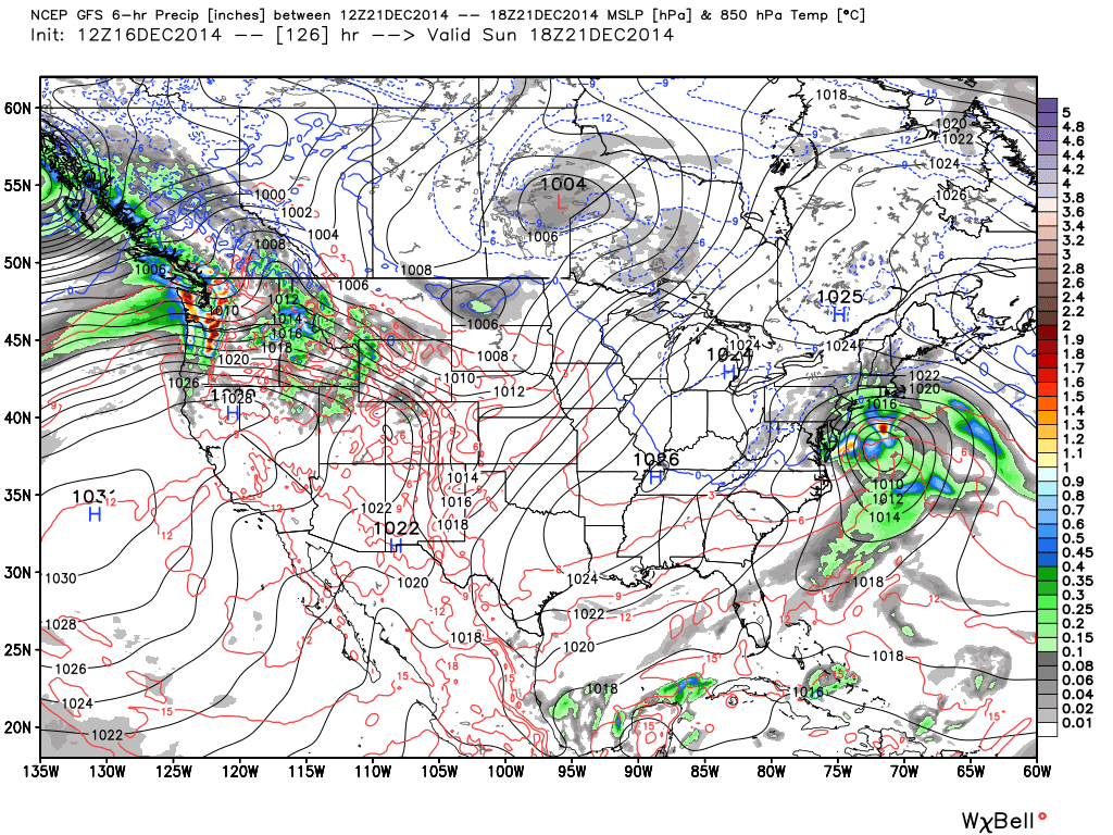
The driving synoptics for a southerly track and weaker storm this Saturday-Sunday is the ripping Pacific jet stream. It’s simply coming into the west coast stronger than modeled which is keeping the general flow over the US flat. For an all out bomb of a storm, you want to see dips and peaks in the jet streams (called a meridional flow). Instead a flat setup downstream (over east coast) is being modeled (called a zonal flow). This zonal flow prevents the low from coming up the coast and bombing out into a nor’easter. With that being said, the low should form in southern TX, move across the gulf states and eject into the Atlantic Ocean over the Carolinas and only turn slightly up the coast. This will still throw a lot of gulf moisture northward which will fall as light to moderate snow across the region but it’s becoming more likely that there will not be a crippling thump of snow. It’s very important to note that the two pieces of energy responsible for phasing into this storm are still not over land. They are in the E. Pacific and are about to make landfall on the west coast. Once these energies get over land, they will be much better sampled by weather sensors and we will lock into a final low track. This could slide back north a bit so we still need to monitor. With that being said, no expected precipitation amounts will be given until probably Thursday. I’ll likely just release a probabilities map tomorrow evening. So…not a miss but not a bomb as of now. Here’s today’s 12Z upgraded GFS showing light to moderate snow for the region on Sunday. The 12Z European operational model as well as its ensemble members support this solution as well. This map shows 850mb pressure and precipitation:
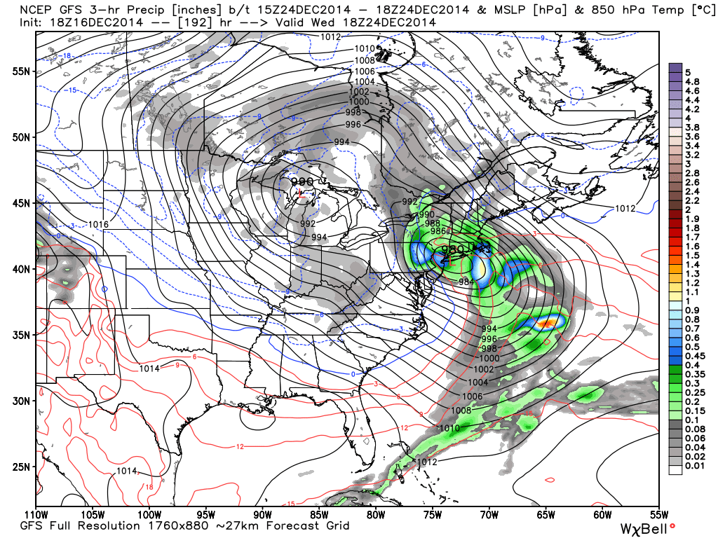
Now lets talk about Christmas. Whatever snow is on the ground from the weekend event could help make or break a White Christmas. With details being laughable at this point (considering how the models handled/have been handling this weekend so far), the overall concept of a storm is showing with a very powerful low pressure system (sub-980mb) transferring into the Atlantic Ocean. As of current model guidance, the low tracks into PA from the SW and then transfers to the Jersey Coast. Assuming this would happen, the system would start out rainy on Christmas Eve and change to snow for Christmas Day. Let’s not get too excited. Let’s focus on storm vs no storm and see how this weekend plays out first. The low this Sunday will have a direct impact on the Christmas system depending on where it tracks in the Atlantic Ocean after ejecting into it from the east coast. This is what the GFS is showing on the afternoon of Christmas Eve. Again, 850mb pressure and precipitation:
In English: A storm is still showing on model guidance that will likely take a southerly track rather than a northerly track. This should bring light to moderate snow to New Jersey Saturday night into Sunday. While a major snow storm is not currently modeled, I’ll be monitoring any trends that occur between now and Thursday morning and will let you know about them as soon as possible. We then watch the December 24-25 period for a powerful storm with high winds. We’re now entering a cold and stormy period that looks to last well into January. Let the model mayhem continue and please remember that they will continue to fluctuate between now and Thursday morning. Be safe! JC
Jonathan Carr (JC) is the founder and sole operator of Weather NJ, New Jersey’s largest independent weather reporting agency. Since 2010, Jonathan has provided weather safety discussion and forecasting services for New Jersey and surrounding areas through the web and social media. Originally branded as Severe NJ Weather (before 2014), Weather NJ is proud to bring you accurate and responsible forecast discussion ahead of high-stakes weather scenarios that impact this great garden state of ours. All Weather. All New Jersey.™ Be safe! JC


LOCAL FORECAST | INTERACTIVE RADAR | LATEST NJ WEATHER ALERTS | WEDDING FORECAST| PRIVACY POLICY
© Copyright 2026 Weather NJ LLC. All Rights Reserved.
Some information that can be found on our website is provided by a private weather station and is not an officially recognized station for weather reporting. Though we always strive to achieve accurate reporting for our own use, it is important that you do NOT depend on the data provided here for any purpose.
