

Dec 17: Coastal Winter Storm Update
Discussion: The coastal storm low is currently just off the tip of Cape May. Here’s the latest SPC Mesoanalysis data:
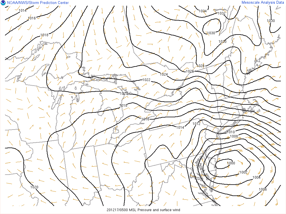
The low should track just offshore of Atlantic City, NJ by ~3am and then gradually pull away to the E through the rest of Thursday morning. Precipitation will start to shut off from S to N just after midnight. SNJ first, CNJ by 5am and then NNJ by 7am.
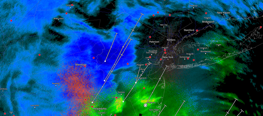
We’re now seeing periods of sleet and dry slotting. The shallow above-freezing layer between 700 and 850mb (the sleet maker) DID poke its nose past 95 but will soon vacate the equation as the approaching shortwave moves colder flow in and helps backfill the precipitation shield with additional pressure drop lifting. We’re currently seeing the dry slots because of the convective nature of sinking air wanting to counteract intense nearby lifting (current precip bands). Also, the coastal low is taking over control of the precipitation shield which can produce dry slots as well.
So once the precipitation shield fills back in (it’s starting to happen now to our SW), the back edge of it will form somewhere in SNJ and slowly move to NENJ (hence NENJ shutting off last). Temperatures will crash at all levels to produce snow only. Therefore, some pretty heavy snow bands should thump across NNJ, maybe some parts of CNJ, between midnight and daybreak.
SNJ/SENJ should continue to stay above freezing via strong onshore marine flow. Sea Surface Temperatures (SSTs) are running 50-51F from Cape May to Sandy Hook. The strong onshore flow should slowly rock counterclockwise from E/NE to N/NE as the low gets closer to AC. Since the low will be so close to SNJ, by the time the winds are N/NE (cold enough for snow), the precipitation will be over for SNJ.
Winds are currently gusting 50+mph along the ocean-facing Jersey coast. Gusts inland seem to be 30-40mph in general. NWNJ a bit calmer wind-wise for now. Winds should continue to crank their hardest from now until about sunrise.
The greatest period of wind-driven storm surge will luckily occur at low tide (around 3am). Therefore, coastal flooding should be held to the minor stage in general. Possibly isolated moderate instances.
In English: The storm started with a snowier thump in SNJ than expected. But the snow/rain line did its thing and now we have dry slotting on radar. That’s not the end of the storm though. Periods of heavy snow are still expected for NNJ and possibly further S in the state. The radar should fill back in by 1am for said areas. The snow should wrap up in NENJ last between 5-7am. These next 6 hours or so will be the last part of the storm. The coldest part with the gnarliest snow bands. Winds are behaving as expected and coastal flooding is not as bad as it could have been. I’ll check back in around 9am. Be safe! JC
Download the free Weather NJ mobile app on Apple or Android. It’s the easiest way to never miss Weather NJ content. Our premium services go even further above and beyond at the hyper-local level. Get your merch on at the KABOOM shop in time for the holidays.
Jonathan Carr (JC) is the founder and sole operator of Weather NJ, New Jersey’s largest independent weather reporting agency. Since 2010, Jonathan has provided weather safety discussion and forecasting services for New Jersey and surrounding areas through the web and social media. Originally branded as Severe NJ Weather (before 2014), Weather NJ is proud to bring you accurate and responsible forecast discussion ahead of high-stakes weather scenarios that impact this great garden state of ours. All Weather. All New Jersey.™ Be safe! JC


LOCAL FORECAST | INTERACTIVE RADAR | LATEST NJ WEATHER ALERTS | WEDDING FORECAST| PRIVACY POLICY
© Copyright 2026 Weather NJ LLC. All Rights Reserved.
Some information that can be found on our website is provided by a private weather station and is not an officially recognized station for weather reporting. Though we always strive to achieve accurate reporting for our own use, it is important that you do NOT depend on the data provided here for any purpose.
