

Dec 17: White Christmas Chances Decreasing
Model guidance has trended away even further from a New Jersey snow storm this Saturday-Sunday. The current modeled forecast for the weekend appears to be some light rain Saturday night followed by scattered snow showers on Sunday morning with accumulations unlikely. The storm has trended so far south, there’s actually a chance of no precipitation whatsoever through Sunday. Model guidance is then keying in on another warmer baby system Monday-Tuesday followed by impacts associated with a powerful Great Lakes storm for Christmas Eve-Day. For the nerdy…read on:
The split jet stream flow has dominated the US setup this week. The idea for the weekend storm was that energy comes off the Pacific into both streams and then phases together over the east coast. Because the flow is so strong off the Pacific, it’s keeping the split jet streams from every getting close enough to phase into a powerful storm. It’s preventing the ridge from forming in the west…that would amplify the storm trough in the southern-central US…that would bring the storm north for the east coast. This combined with strong combo of high pressure and 50/50 low to the north just keeps everything generally flat and weak allowing the storm to slide off the SE US coast—without ever turning northward to strengthen. Does the storm pass close enough to our south to kick some light rain and snow showers northward Saturday night into Sunday? Maybe but I wouldn’t get too excited. For good measure, I will continue to monitor model guidance tonight (00Z) and tomorrow (12Z suite) to see if there are any changes with better-sampled data but I’m 75% sold that the Saturday-Sunday storm will miss to our south. There’s no point in showing any guidance related to this unless it comes back north.
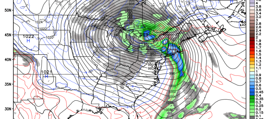
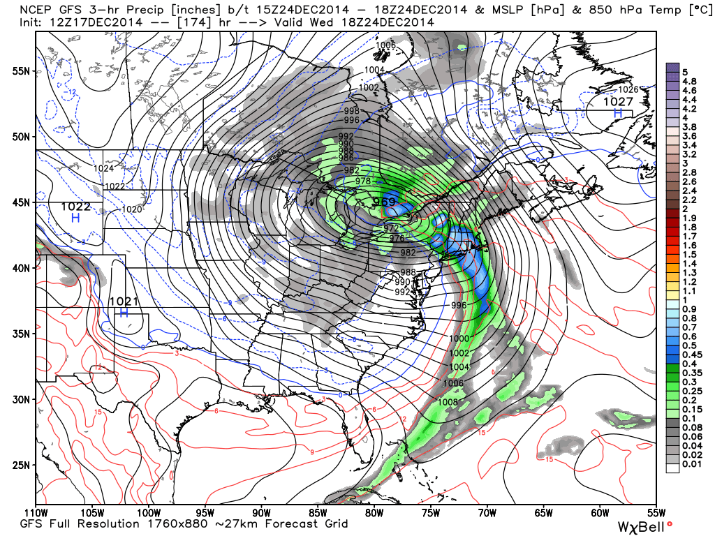
Moving forward…a warmer coastal low pressure disturbance could then bring rain to New Jersey in the Monday-Tuesday time frame. No big deal. Then the main focus is on a massive trough of cold air that will plunge into the central US from Canada behind a very powerful low pressure system. I’ve seen it modeled as low as 958mb but at least a sub-980mb on all other guidance. The low comes off the Pacific Ocean into the NW US…dives as far south as Texas…then turns back northward to the Great Lakes Region. This would bring a period of rain and wind to New Jersey on Christmas Eve followed by strong W/NW bitter-cold winds for Christmas Day with just a few possible snow showers. We would then moderate in temperature for a short period before a cold front moves through and opens up the Arctic gates to close out 2014. Here’s the GFS showing the rapidly strengthening low pressure system over the Great Lakes on Christmas Eve.
I know it’s heart breaking for the snow lover to hear this information after all the model analysis and discussion but it’s important that everyone has the best and most current info when planning, traveling, shopping, etc. around the holidays. Some of you will be happy that there’s little to stand in the way of these thing. Like I said, I will continue to monitor guidance but for New Jersey but it looks like we will have to wait a bit longer to get our snow. The pattern and temperature profiles just doesn’t support it yet.
In English: A snow storm this weekend is unlikely now. Instead you might see some light precipitation in the form of rain or snow showers Saturday night into Sunday. If the system misses far enough south you might not see anything at all. Nuisance stuff if it happens. Looking ahead, there might be some rain and wind on Christmas Eve followed by bitter-cold wind chills on Christmas Day. Be safe! JC
Jonathan Carr (JC) is the founder and sole operator of Weather NJ, New Jersey’s largest independent weather reporting agency. Since 2010, Jonathan has provided weather safety discussion and forecasting services for New Jersey and surrounding areas through the web and social media. Originally branded as Severe NJ Weather (before 2014), Weather NJ is proud to bring you accurate and responsible forecast discussion ahead of high-stakes weather scenarios that impact this great garden state of ours. All Weather. All New Jersey.™ Be safe! JC


LOCAL FORECAST | INTERACTIVE RADAR | LATEST NJ WEATHER ALERTS | WEDDING FORECAST| PRIVACY POLICY
© Copyright 2026 Weather NJ LLC. All Rights Reserved.
Some information that can be found on our website is provided by a private weather station and is not an officially recognized station for weather reporting. Though we always strive to achieve accurate reporting for our own use, it is important that you do NOT depend on the data provided here for any purpose.
