

Dec 18: Cold Air Arrives
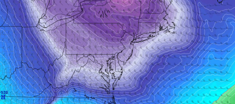
Discussion: The upper-level jet and a closed-off upper-level low will swing through the extreme NE US between now (Wednesday) and Friday. This should result in cold NW winds at the surface for all of New Jersey in that same time period.
Right now the lake effect machine is turned on. Cold air is passing over the Great lakes and evaporating the moisture into snowfall downwind for the Mid-Atlantic US. The colder NW flow is helping the convective squalls and snow showers reach parts of New Jersey. These nuisance temporary instances of blinding snowfall can even lay down trace-to-light accumulations. They should taper off by about 8 or 9pm this evening (Wednesday) leaving the skies just cold and breezy/gusty out of the NW.
Overnight temperatures tonight should range from possibly single-digits in NNJ to the 20s in extreme SNJ. High temperatures tomorrow (Thursday) are expected to remain below freezing. We should then drop into very cold territory Thursday night into Friday.
We should moderate some for Saturday and Sunday. While it will feel much warmer than how tonight through Friday will feel, it will still be relatively cold. I will cover this in detail in tomorrow’s weekend outlook. For now I recommend making any common-sense preparations for 48-60 hours of Arctic air mass. This includes trickling water spouts, making sure your outside hoses are disconnected/shut off, making sure your pets are not left outside very long, etc.
The December 21-23 storm signal has dropped off the table of interest. The storm will form but suppressed by high pressure/ridging way to the S near Florida. It seems that the Disney Star Wars Marketing Vortex surrounding Orlando, FL has pulled the storm’s track southward into Florida. Solo Vortex? With that said the Holiday period looks calm and mostly dry for any travel concerns. There are a few early snow signals, for the very end of this year/first few days of next year, that we might end up tracking aggressively if they are still showing during the Christmas period. For now the possibility of a White Christmas remains very low. It likely won’t happen from a synoptic storm but you never know about last-minute clippers and lake effect snow bands. We’ll see.
In English: Snow showers and squalls should continue through evening hours. Flizzards can significantly and temporarily limit visibility so please be careful. They can even lay trace-to-light snow accumulations down in a brief amount of time. Temperatures should then drop very cold overnight tonight and stay below freezing even for highs tomorrow. Thursday night into Friday also looks well below-average in temperature but with less wind. It all looks dry though even through the weekend when temperatures slightly moderate. I’ll go into more weekend details tomorrow in the weekend outlook. Everyone have a great rest of your Wednesday night. Stay warm and be safe! JC
Download the new free Weather NJ mobile app on Apple and/or Android. It’s the easiest way to never miss Weather NJ content. Our premium services go even further above and beyond at the hyper-local level. Looking for industrial-caliber long-range forecasting data that I personally recommend? Check out WeatherTrends360! Visit the Weather NJ Kaboom Shop for hoodies, tees and infant onesies.
Jonathan Carr (JC) is the founder and sole operator of Weather NJ, New Jersey’s largest independent weather reporting agency. Since 2010, Jonathan has provided weather safety discussion and forecasting services for New Jersey and surrounding areas through the web and social media. Originally branded as Severe NJ Weather (before 2014), Weather NJ is proud to bring you accurate and responsible forecast discussion ahead of high-stakes weather scenarios that impact this great garden state of ours. All Weather. All New Jersey.™ Be safe! JC


LOCAL FORECAST | INTERACTIVE RADAR | LATEST NJ WEATHER ALERTS | WEDDING FORECAST| PRIVACY POLICY
© Copyright 2026 Weather NJ LLC. All Rights Reserved.
Some information that can be found on our website is provided by a private weather station and is not an officially recognized station for weather reporting. Though we always strive to achieve accurate reporting for our own use, it is important that you do NOT depend on the data provided here for any purpose.
