

Dec 2: Coastal Snow Storm Arriving
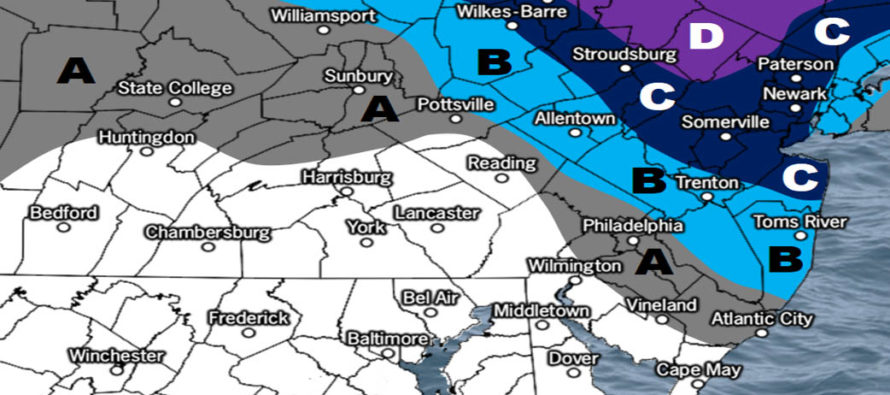
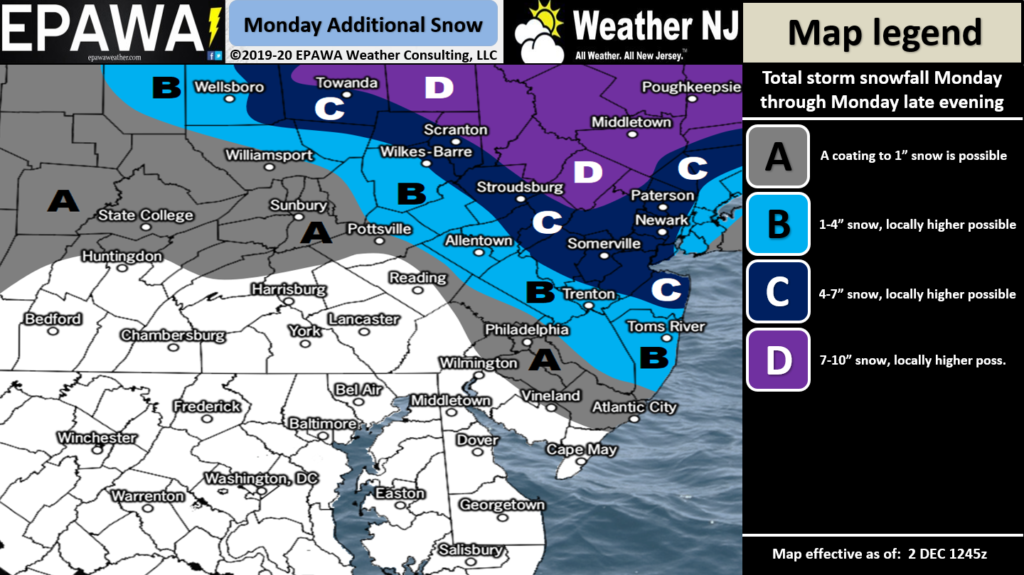
Discussion: One final snow map tweak heading into phase 3 of this system. When we made our map yesterday afternoon there was little data to support higher snow totals further S and SE in New Jersey. Since then (last night and early this morning) model guidance has trended towards our gut suspicion of a colder and snowier outcome for parts of CNJ/ECNJ not just NNJ/NWNJ. NNJ/NWNJ still looks to jackpot from this system (highest totals in NJ) but we now have to bring plowable accumulations well into CNJ and light-to-plowable accumulations into northern parts of SNJ.
Rain is already changing over to snow NW of the I-95/NJTP corridor. I expect this changeover to continue from N to S and turn all NJ areas over to snow by noonish today. Snowfall should then fall through afternoon and evening hours and wrap up just on either side of midnight.
It is important to consider a few things. There will be heavier bands of snow with adjacent areas of light snow. We don’t know where these bands will set up exactly and therefore will have to be now-casted. Also the surface is still relatively warm (slightly above freezing) for most of CNJ and SNJ. It’s not a problem in NNJ but CNJ and SNJ accumulations will be dependent on precipitation bringing colder air down from aloft. The increase for CNJ/SNJ snow amounts likely comes at the cost of lesser amounts for E PA via dry slot/transfer. As I said in last night’s article this is a very challenging system. With that said here is the last final adjustment before snow gets going today. Thank you for your patience and understanding!
Click here for full-resolution snow map!
In English: Rain will change to snow from N to S today. It’s already there NW of the turnpike and all other areas will likely go over to snow by noon. Snowfall will then fall through afternoon/evening hours and wrap up somewhere around midnight maybe slightly after. The above snowmap represents our expectations when all is said and done. The PM rush hour commute does not look good for many in NNJ/CNJ and now possibly some northern parts of SNJ. Have a great Monday and please be safe! JC
Download the new free Weather NJ mobile app on Apple and/or Android. It’s the easiest way to never miss Weather NJ content. Our premium services go even further above and beyond at the hyper-local level. Looking for industrial-caliber long-range forecasting data that I personally recommend? Check out WeatherTrends360! Visit the Weather NJ Kaboom Shop for hoodies, tees and infant onesies.
Jonathan Carr (JC) is the founder and sole operator of Weather NJ, New Jersey’s largest independent weather reporting agency. Since 2010, Jonathan has provided weather safety discussion and forecasting services for New Jersey and surrounding areas through the web and social media. Originally branded as Severe NJ Weather (before 2014), Weather NJ is proud to bring you accurate and responsible forecast discussion ahead of high-stakes weather scenarios that impact this great garden state of ours. All Weather. All New Jersey.™ Be safe! JC


LOCAL FORECAST | INTERACTIVE RADAR | LATEST NJ WEATHER ALERTS | WEDDING FORECAST| PRIVACY POLICY
© Copyright 2026 Weather NJ LLC. All Rights Reserved.
Some information that can be found on our website is provided by a private weather station and is not an officially recognized station for weather reporting. Though we always strive to achieve accurate reporting for our own use, it is important that you do NOT depend on the data provided here for any purpose.
