

Dec 24: Monitoring next Monday-Wednesday for Snow
The rain will clear out overnight and the weekend looks pretty good with high pressure in full control. For a few runs now and on multiple models, a weak low pressure disturbance looks to follow the departing high next Monday-Wednesday. I can’t emphasize enough that this is a mid-to-long range possibility at this point. I’m just tracking it because it now has my interest.
The Arctic air mass is still set to invade immediately after this system passes through and does whatever it does. With that being said, we have to consider the possible impacts of the strong Pacific Jet stream and/or the cold suppression keeping this system weaker and out to sea—just like the system that was modeled for this past weekend. However, if the high departs just right with the cold air digging in behind, we could be looking at a significant snow event for New Jersey. It’s too soon to carve up the state snow/rain line. If this system stays on guidance into the short-to-mid range, then that will happen. There is also a disagreement in timing. Let’s look at some guidance:
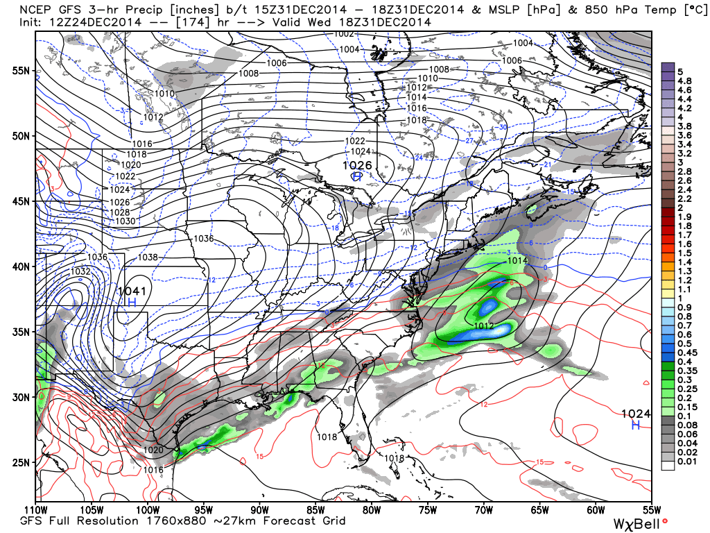
The 12Z GFS buys into the squashed southerly solution and only brings light snow showers to SNJ. This map shows 850mb pressure, temperature, and precipitation falling between Wednesday morning and Wednesday afternoon (December 31).
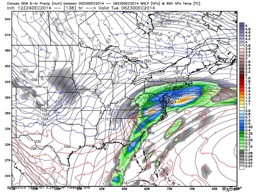
The 12Z Canadian GEM has a much stronger solution which brings significant snow to most of New Jersey. This map also shows 850mb pressure, temperature, and precipitation but falling between Monday night and early Tuesday morning (December 29-30). The 12Z European model appears to be split between the 12Z GFS and 12Z Canadian.
In English: Rain ends overnight tonight. High pressure keeps us sunny, mild and dry through the weekend. Anything from light snow showers in SNJ to a full blown snow storm is possible in the Monday-Wednesday period depending on timing and influence from the Pacific Jet and/or Arctic cold air mass moving in. Just monitoring for now…no reason to sound any alarms. Let’s see where it is 24 hours from now. Be safe and have a great Christmas Eve! JC
Jonathan Carr (JC) is the founder and sole operator of Weather NJ, New Jersey’s largest independent weather reporting agency. Since 2010, Jonathan has provided weather safety discussion and forecasting services for New Jersey and surrounding areas through the web and social media. Originally branded as Severe NJ Weather (before 2014), Weather NJ is proud to bring you accurate and responsible forecast discussion ahead of high-stakes weather scenarios that impact this great garden state of ours. All Weather. All New Jersey.™ Be safe! JC


LOCAL FORECAST | INTERACTIVE RADAR | LATEST NJ WEATHER ALERTS | WEDDING FORECAST| PRIVACY POLICY
© Copyright 2026 Weather NJ LLC. All Rights Reserved.
Some information that can be found on our website is provided by a private weather station and is not an officially recognized station for weather reporting. Though we always strive to achieve accurate reporting for our own use, it is important that you do NOT depend on the data provided here for any purpose.
