

Dec 24: Thunderstorm Update + Wintry Signal

We’ve got a lot to talk about between temperatures and thunderstorms today as well as wintry weather early next week. Let’s dive right in.
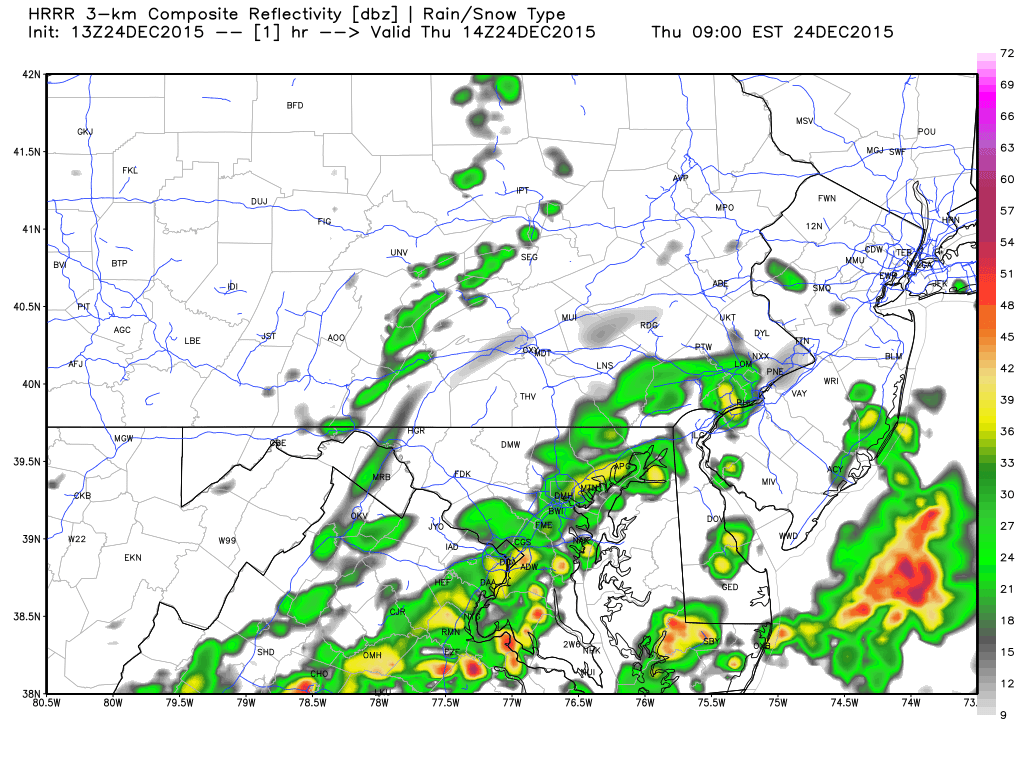
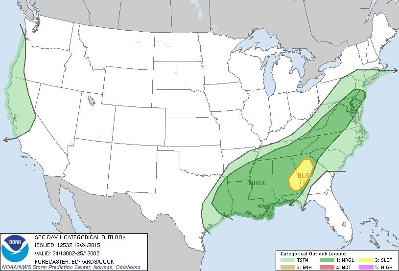
The above animation is a WeatherBell Analytics (used with permission) precipitation radar simulation from the 12Z HRRR (High Resolution Rapid Refresh) model. It favors CNJ and SNJ for the heaviest periods of rain over the next 8 hours or so. Thunderstorms are very possible scattered within these areas of rainfall. The NWS SPC has CNJ and SNJ in the marginal risk category for such:
Temperatures are already into the upper-60s statewide and should push well into the 70s for many areas, especially interior CNJ/SNJ. SBCAPE values should reach the 1000-1500 j/kg zone during early afternoon while MLCAPE levels reach about 500 j/kg. This instability would be barely marginal for summer but is kind of unique for winter. Wind shear is plentiful ahead of the cold front due the southern jet off the GOMEX feeding into the differential flow behind the cold front (thanks to high pressure establishing in the Missouri/Illinois area). We should have about 40-50kts of sfc-500mb bulk shear by afternoon. The cold front should eventually push through this marginal environment later today/this evening. Therefore, until that happens, everyone ahead of it (to the east) is subject to thunderstorms embedded within the rainfall. The strongest parameters exist to the SW. Again, CNJ/SNJ seems favored for this with NNJ a lesser chance due to proximity of battling the high.
Now let’s talk about early next week. Model guidance has been converging on a colder solution for the expected ~December 29 rainfall. A low pressure system is expected to form in the SW US, swing through the S US and then cut northward into the Great Lakes. With that said, this storm is definitely going to end as rain. The wintry concern is for when precipitation starts Monday night overnight into Tuesday morning. The surface atmosphere will still be cold from high pressure influence the few days before. As the warmer levels advect into this colder air, it will take some time to warm the surface. Therefore, we’re looking at NNJ possibly starting as snow and then changing to sleet/ZR—ultimately rain. CNJ could start as a wintry mix before changing to rain. So this really only affects the overnight hours and morning commute for NNJ and CNJ. SNJ is still modeled as all rain and that seems to fit the temperature profile. Once the changeover happens for points north, it will just be a rainy day. For areas N and W of New Jersey, this could be a decent snow storm.
In English: Today will be very mild with pockets of moderate-to-heavy rain and thunderstorms possible. A better chance for this exists in CNJ/SNJ than NNJ. Everything should clear out for most by late afternoon/evening with the exception of extreme SNJ/SENJ. Clouds and showers could possibly linger into tomorrow AM for such areas. We’ll see…hoping it clears earlier. Light rain is expected for the weekend but then a wintry mix is possible Monday night into Tuesday morning for NNJ/CNJ before changing to rain. SNJ should stay all rain. Overall, the weather looks very unsettled through the rest of the year. Have a great day and be safe! JC
Jonathan Carr (JC) is the founder and sole operator of Weather NJ, New Jersey’s largest independent weather reporting agency. Since 2010, Jonathan has provided weather safety discussion and forecasting services for New Jersey and surrounding areas through the web and social media. Originally branded as Severe NJ Weather (before 2014), Weather NJ is proud to bring you accurate and responsible forecast discussion ahead of high-stakes weather scenarios that impact this great garden state of ours. All Weather. All New Jersey.™ Be safe! JC


LOCAL FORECAST | INTERACTIVE RADAR | LATEST NJ WEATHER ALERTS | WEDDING FORECAST| PRIVACY POLICY
© Copyright 2026 Weather NJ LLC. All Rights Reserved.
Some information that can be found on our website is provided by a private weather station and is not an officially recognized station for weather reporting. Though we always strive to achieve accurate reporting for our own use, it is important that you do NOT depend on the data provided here for any purpose.
