

Dec 24: Wind Event Approaching
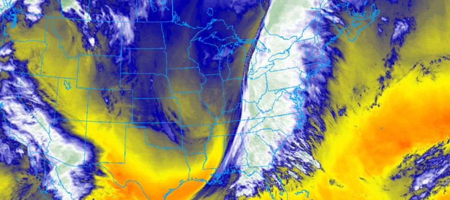
Discussion: Nothing has changed since Tuesday’s article regarding the physics of tonight. We have a deep trough swinging negative with a raging 250mb S jet passing over NJ. To our W, we’re expecting closed-off lows in the mid-to-upper levels (700-500mb) which should provide additional energy and vertical wind shear along an aggressive cold front passage. Surface winds should rip out of the S/SE under an 850mb and up jet raging out of the S/SW.
850mb (about 5,000 feet above sea level) winds should be around 70mph during peak storm time tonight. Surface winds should be sustained 20-30mph with gusts to 45mph. They are already creeping up now. So if none of those 850mb winds are brought down to the surface, then we’re looking at a run-of-mill windy frontal passage tonight. However, if additional convective dynamics get involved, specifically down drafting created from heavy precipitation or horizontal wind shear roll, then the surface could be looking at another gear of wind gusts in the 60-70+mph hour range. There is also a weak low expected to traverse the front from S to N through PA. This could generate additional lifting and ultimately counteracting sinking capable of bringing those stronger gusts down. ECNJ/SENJ is favored to take the winds to the face out of the S/SE and should therefore see the highest clocked wind gusts overnight tonight. Wind values away from the ocean should be less but still rocking.
As far as timing goes, this thing is in PA and knocking on NJ’s door now. Rain should spread into WNJ first between now and early-evening hours. Rain should be into all of NJ by late-evening hours. Peak rain intensity should then occur overnight until about 4-6am tomorrow (Friday) morning. It probably won’t be a continuous downpour for 8-10 hours, more of a on-and-off stormy feel.
So rain and wind is a given tonight as we ride out the warm sector of a very dynamic mid-latitude system. Let’s allow a reasonable chance for thunderstorms to develop along the heaviest frontal precipitation. We have some fairly strong clashing of air masses here with a tight thermal gradient. Given the “close-enough” alignment between the surface and 850mb winds (S/SE and S/SW), most damaging wind potential should be in the form of straight line, however let’s allow a super small chance of an isolated tornado just to play it safe.
This was a great setup for a winter storm but everything was about 500 miles too far NW. Otherwise NJ would be in on the snow storm that the E Great Lakes are about to get. The pattern remains very actively modeled as we close out 2020 and enter 2021. I’ll talk more about that tomorrow.
In English: Rain and wind are approaching from the W. It should get pretty gnarly later this evening into early Friday morning. Heavy downpours could lead to flash flooding. High winds will likely produce power outages and possibly damaging gusts, especially along the ECNJ/SENJ coast. The worst of it should be between about 8pm tonight and 4am tomorrow morning (from W to E). It should all clear the E coast of NJ by 6am tomorrow yielding a much colder and more wintry feeling Christmas Day with a small chance of passing flurries. I’ll cover some longer-range storm signals tomorrow in the weekend outlook. Everyone have a great Christmas Eve and please be safe! JC
Download the free Weather NJ mobile app on Apple or Android. It’s the easiest way to never miss Weather NJ content. Our premium services go even further above and beyond at the hyper-local level. Get your merch on at the KABOOM shop in time for the holidays.
Jonathan Carr (JC) is the founder and sole operator of Weather NJ, New Jersey’s largest independent weather reporting agency. Since 2010, Jonathan has provided weather safety discussion and forecasting services for New Jersey and surrounding areas through the web and social media. Originally branded as Severe NJ Weather (before 2014), Weather NJ is proud to bring you accurate and responsible forecast discussion ahead of high-stakes weather scenarios that impact this great garden state of ours. All Weather. All New Jersey.™ Be safe! JC


LOCAL FORECAST | INTERACTIVE RADAR | LATEST NJ WEATHER ALERTS | WEDDING FORECAST| PRIVACY POLICY
© Copyright 2026 Weather NJ LLC. All Rights Reserved.
Some information that can be found on our website is provided by a private weather station and is not an officially recognized station for weather reporting. Though we always strive to achieve accurate reporting for our own use, it is important that you do NOT depend on the data provided here for any purpose.
