

Dec 28: Final Call and Impact Map for Thursday
Here’s our final call for Thursday…
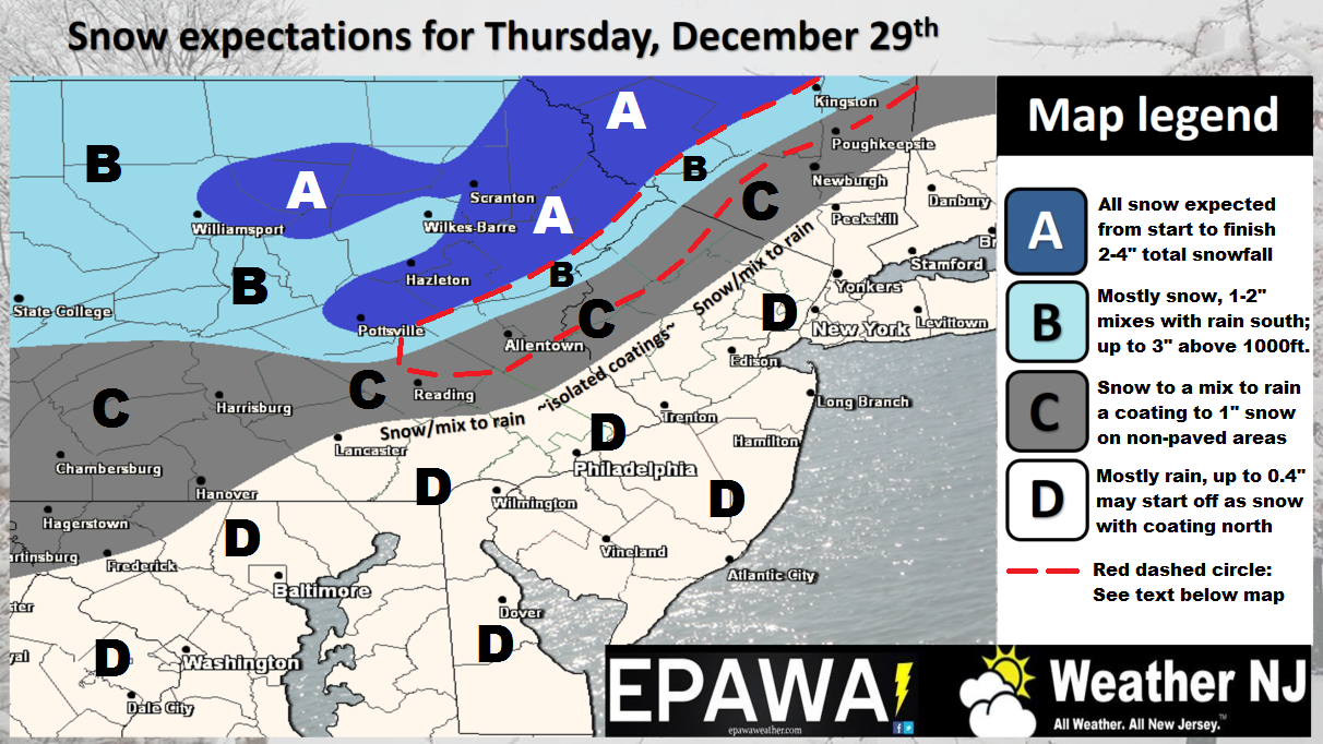
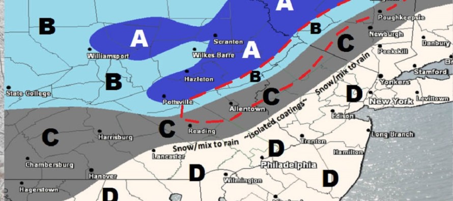
Click here to view impact map in full resolution.
Red Dashed Area: Snow may continue to fall for a longer period, but may have a difficult time accumulating once surface temperatures climb slightly above freezing Thursday morning, aside from colder non-paved surfaces.
Disco: Low pressure is currently tracking just to the N of the Great Lakes. It will transfer to the coast and bomb out for coastal New England. Much of immediate coastal New England is expecting lower accumulations due to onshore flow influence. Interior New England however, especially the Catskills through VT, should expect a nice winter storm from this. Only the elevations of NWNJ have a chance for accumulations Jersey-wise. The lower 2/3 of New Jersey will battle a warmer surface due to SE flow off the 40+ degree ocean. The mid-levels of the troposphere however are cold enough to support snowfall down into the Newark Basin. Therefore we could have a lot of snow falling for NNJ and maybe even parts of CNJ but not sticking. I doubt non-accumulating snowfall would come SE of the I-95 corridor though. Those along 95 and SE from there should expect a cold rain. Again, the NWNJ elevations have the best chance for light accumulations from this event.
In English: Light accumulations of snow are expected tomorrow for the elevations of NWNJ. The rest of New Jersey will likely be too warm for stickage. Most of the lower 2/3 of New Jersey should expect a cold rain. The above map illustrates our final call heading into tomorrow. Precip starts in the morning and wraps up by evening followed by gusty NW winds overnight into Friday. Be safe! JC
Jonathan Carr (JC) is the founder and sole operator of Weather NJ, New Jersey’s largest independent weather reporting agency. Since 2010, Jonathan has provided weather safety discussion and forecasting services for New Jersey and surrounding areas through the web and social media. Originally branded as Severe NJ Weather (before 2014), Weather NJ is proud to bring you accurate and responsible forecast discussion ahead of high-stakes weather scenarios that impact this great garden state of ours. All Weather. All New Jersey.™ Be safe! JC


LOCAL FORECAST | INTERACTIVE RADAR | LATEST NJ WEATHER ALERTS | WEDDING FORECAST| PRIVACY POLICY
© Copyright 2026 Weather NJ LLC. All Rights Reserved.
Some information that can be found on our website is provided by a private weather station and is not an officially recognized station for weather reporting. Though we always strive to achieve accurate reporting for our own use, it is important that you do NOT depend on the data provided here for any purpose.
