

Dec 28: First Call Snow Map for Saturday
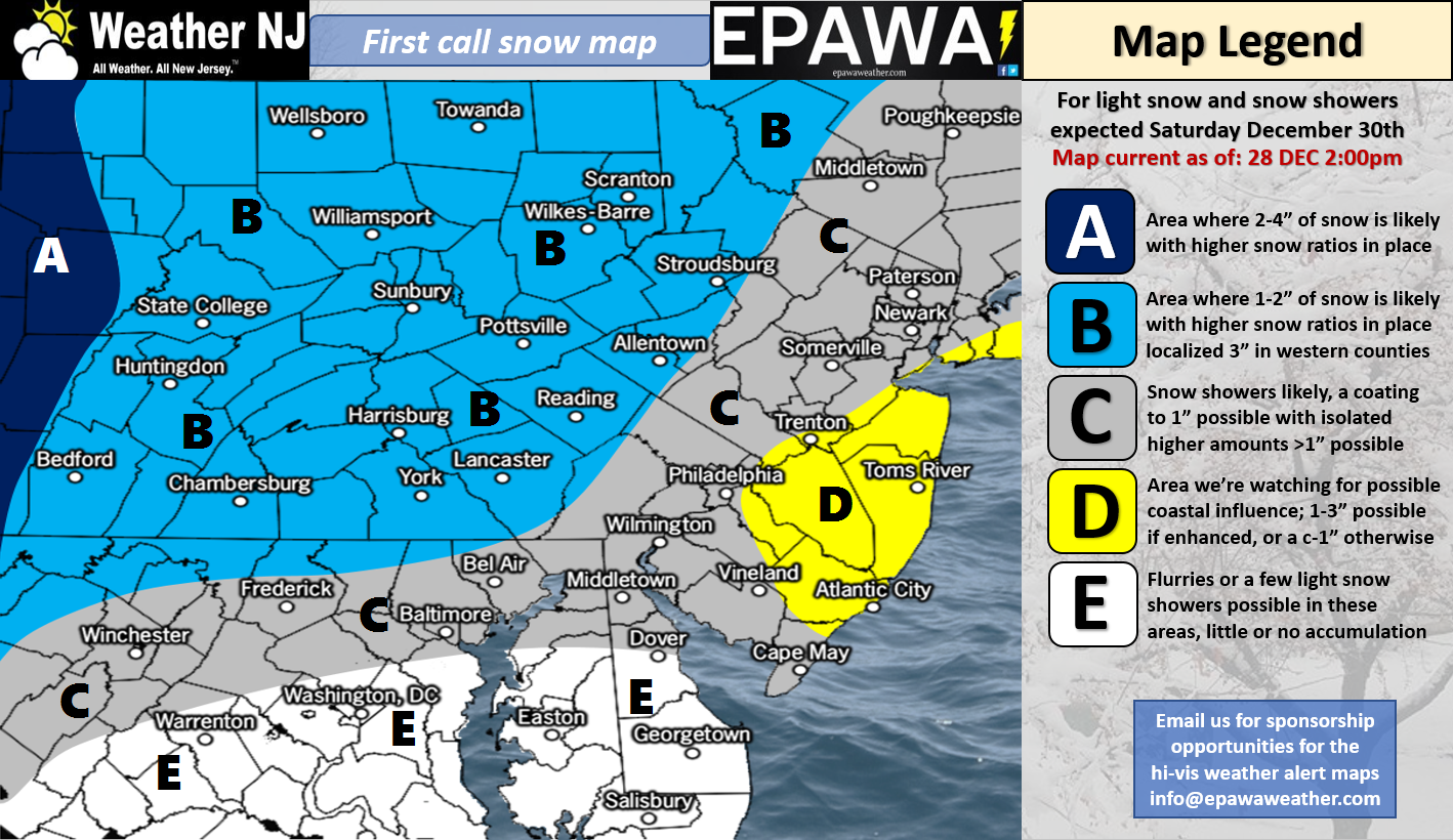
Click here to view full resolution snow map!
Discussion: An area of northern stream energy will pass through New Jersey on Saturday from W to E. This energy split off of an incoming wave from the Pacific Ocean near Washington State. By itself, this northern system has the likelihood of throwing down a widespread coating to an inch or two for all of New Jersey.
We’re also watching a weak coastal surface low that should develop off OBX Saturday morning and track to the NE. If this coastal low tracks a little closer to N/NE then it would enhance expected accumulations for the general yellow area. Instead of C-2, you might see 2-3 possibly a little more. If the coastal low tracks a little more to the E/NE then there would be less coastal enhancement potential and we would likely just deal with whatever the northern stream system delivered only.
Regardless, this snowfall is expected to take place in a very cold and dry air mass. We could see a little virga to start (snow that evaporates before reaching the ground) as dew points climb to meet temperatures. Northern stream systems are starved of moisture in general which is why they often only result in a few powdery inches at most. With expected snow ratios of 22:1 NW of the NJTP and 18:1 SE of the NJTP, the low moisture is counter-balanced with the higher snow ratios. This is why the possible coastal enhancement is so important for the yellow area. If it happens it could seem like a surprise stack up of possibly disruptive accumulations on all surfaces. If the coastal enhancement does not happen, you could still see slick roadways. Every flake should stick and most salt should have trouble keeping standing puddles unfrozen.
The models almost lost this system completely yesterday. Overnight and today they brought it back to what our above map currently represents. The foreign models (Euro/CMC/UK) have done a much better job than the domestic models (GFS/NAM) holding the overall signal but here we are today coming to a consensus… a light event for most with possibly more closer to the ocean, again from possible coastal enhancement. Our best timing anticipation is between sunrise and afternoon on Saturday. If it’s still snowing in ENJ after sundown on Saturday then the it’s safe to say the coastal surprise has happened. If the snowfall shuts off early Saturday afternoon then you will probably only have the C-1″/C-2″ scenario on the ground.
The January 3-4 winter storm signal is still modeled strong however we’re 6-7 days away. If the storm signal is still this strong in the day 3-4 period (this Sat-Sun) then it will be time to track seriously for a significant winter storm next Wednesday-Thursday.
In English: Most of New Jersey should expect a coating to an inch or two between this Saturday morning and afternoon. It’s the real fluffy and powdery stuff due to the extreme cold temperatures. A coastal area of low pressure could take the yellow zone up a few inches if it properly enhances the precipitation shield. otherwise, the yellow area is the same as the rest of New Jersey’s gray area. Our final call will go out tomorrow evening and we’ll adjust accordingly based on our coastal enhancement analysis. Jan 3-4 winter storm signal is still on the table it’s just a little too far out to lock in. Let’s revisit later this weekend. Have a great night and please be safe! JC
For comprehensive and interactive hyper-local analysis that goes way above and beyond the detail of this public forecast, check out our premium services which include text notifications and forum access.
Jonathan Carr (JC) is the founder and sole operator of Weather NJ, New Jersey’s largest independent weather reporting agency. Since 2010, Jonathan has provided weather safety discussion and forecasting services for New Jersey and surrounding areas through the web and social media. Originally branded as Severe NJ Weather (before 2014), Weather NJ is proud to bring you accurate and responsible forecast discussion ahead of high-stakes weather scenarios that impact this great garden state of ours. All Weather. All New Jersey.™ Be safe! JC


LOCAL FORECAST | INTERACTIVE RADAR | LATEST NJ WEATHER ALERTS | WEDDING FORECAST| PRIVACY POLICY
© Copyright 2026 Weather NJ LLC. All Rights Reserved.
Some information that can be found on our website is provided by a private weather station and is not an officially recognized station for weather reporting. Though we always strive to achieve accurate reporting for our own use, it is important that you do NOT depend on the data provided here for any purpose.
