

Jan 3: Winter Storm Approaching!
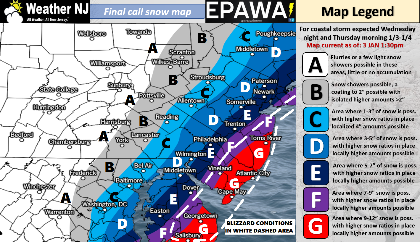
Please click here for full-resolution snow map!
Discussion: The surface low that will become the powerful ocean low is in the process of interacting with the upper level energy approaching from the W. It’s all wrapping up as expected into what should be a significant-to-major snow storm especially for coastal SNJ counties. The areas in red (zone G) should likely Kaboom. Zones D, E and F should still see significant/plowable totals. Areas A, B and C should obviously see less given their further proximity from the core coastal snow bands that should form to their SE.
Snow could start in SENJ as early as 9PM tonight but likely by midnight. Snowfall should then spread into the entire state through the early AM hours of Thursday (early tomorrow morning). Showfall should really crank from tomorrow morning through tomorrow afternoon before tapering off around or just before sunset on Thursday from W to E.
High winds are expected with this system. I wouldn’t rule out a few gusts exceeding 45mph with sustained winds of 15-25mph or greater. The white dotted line outlines the best chance for near-blizzard or possibly even blizzard conditions. This should be felt more the closer you are to the ocean. Therefore power outages are likely. Also, the winds could beat the coast up pretty good. I would at least expect beach erosion and minor flooding, possibly moderate flooding given the further west track of the ocean low.
There are still a few wildcards that could happen. Our snow map represents our best evidence-based expectation however there are always mesoscale occurrences that could happen such as mesoscale banding or convective-related dry-slotting. If mesoscale banding were to occur for a prolonged period of time over any one region then totals would increase substantially. We believe that the red area has the best chance for this…and therefore the best chance to Kaboom. If the heaviest bands form off the ocean or further to the NW then the red area could actually become snowfall-inhibited. Such occurrences will be identified in real-time should they happen. Just want to express full disclosure that there is still uncertainty with this system. Otherwise, our map represents our thoughts.
In English: I’ve seen a few headlines surrounding this storm the past few days. Let’s just go with Kaboombogenesis! A powerful winter storm will throw a decent amount of snow off the ocean between tonight and tomorrow afternoon. Peak storm intensity should be mid-to-late morning tomorrow. High winds, power outages and coastal flooding are likely with this system. Zone G has the best chance to Kaboom (12+ inches). The white dotted line is where blizzard criteria could possibly be met. Everyone please be safe and have a great night. I have a little surprise for you later tonight when precipitation approaches 8) Be safe! JC
For comprehensive and interactive hyper-local analysis that goes way above and beyond the detail of this public forecast, check out our premium services which include text notifications and premium forum access.
Jonathan Carr (JC) is the founder and sole operator of Weather NJ, New Jersey’s largest independent weather reporting agency. Since 2010, Jonathan has provided weather safety discussion and forecasting services for New Jersey and surrounding areas through the web and social media. Originally branded as Severe NJ Weather (before 2014), Weather NJ is proud to bring you accurate and responsible forecast discussion ahead of high-stakes weather scenarios that impact this great garden state of ours. All Weather. All New Jersey.™ Be safe! JC


LOCAL FORECAST | INTERACTIVE RADAR | LATEST NJ WEATHER ALERTS | WEDDING FORECAST| PRIVACY POLICY
© Copyright 2026 Weather NJ LLC. All Rights Reserved.
Some information that can be found on our website is provided by a private weather station and is not an officially recognized station for weather reporting. Though we always strive to achieve accurate reporting for our own use, it is important that you do NOT depend on the data provided here for any purpose.
