

Dec 3: Light Snow Event for NJ Elevations Expected
We’ve got a light snow event approaching for parts of NNJ Sunday evening into Monday morning. Let’s break it down…
Two waves will pass through our region from west to east. The northern energy will be in the form of a weakening upper-level shortwave that’s currently moving through the northern-central US. The southern energy will form near the coast of NC/SC and eject into the Atlantic Ocean. They will not phase together completely but will interact just enough for a light snow event for NNJ elevations and surrounding areas tomorrow evening into Monday morning. Given the marginal temperature profile, areas north of I-78 and NW of I-95 are most favored. Eastern PA Weather Authority and Weather NJ have collaborated on the following impact map:
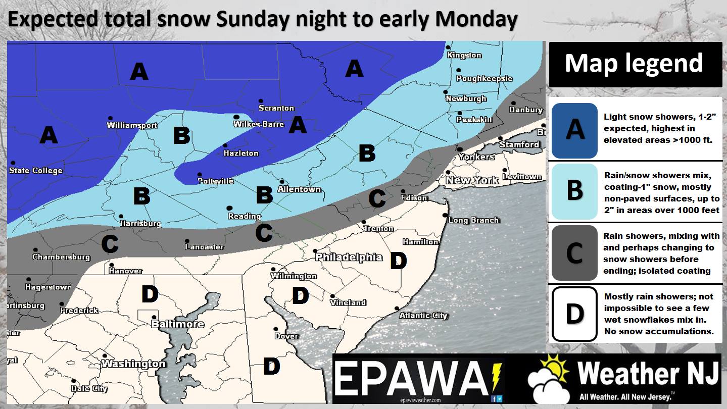
In English: Anything from a coating to a few inches of snow accumulation are possible for NNJ, especially for elevations of NWNJ. Timing is looking like Sunday evening into Monday morning. All lower elevations of New Jersey should expect a mostly cold rain solution with snow possibly mixing in closer to elevated points north and west. If you’re in the white or even gray of the above map, this is not a big deal at all. If you’re in the light blue you have the best chance to see light accumulations. Be safe! JC
Jonathan Carr (JC) is the founder and sole operator of Weather NJ, New Jersey’s largest independent weather reporting agency. Since 2010, Jonathan has provided weather safety discussion and forecasting services for New Jersey and surrounding areas through the web and social media. Originally branded as Severe NJ Weather (before 2014), Weather NJ is proud to bring you accurate and responsible forecast discussion ahead of high-stakes weather scenarios that impact this great garden state of ours. All Weather. All New Jersey.™ Be safe! JC


LOCAL FORECAST | INTERACTIVE RADAR | LATEST NJ WEATHER ALERTS | WEDDING FORECAST| PRIVACY POLICY
© Copyright 2026 Weather NJ LLC. All Rights Reserved.
Some information that can be found on our website is provided by a private weather station and is not an officially recognized station for weather reporting. Though we always strive to achieve accurate reporting for our own use, it is important that you do NOT depend on the data provided here for any purpose.
