

Dec 4: Wintry Precipitation Approaching
This will be the last forecast article for this system. Live observations from hereon out…
Two weak systems are passing to our N and S but close enough to enhance precipitation through all of New Jersey overnight and into tomorrow morning. I don’t expect much of anything before midnight tonight. The exact timing window of this event should be between midnight and 8AM tomorrow morning. With that said, areas of wintry precipitation concern should allow a little extra time for the Monday AM commute.
The temperature profile is very marginal, meaning a line of snow/rain should set up somewhere between CNJ and NNJ with NWNJ elevations having the best chance for light accumulations and SNJ/SENJ having the best chance for all cold rain—with everyone between subject to mixed precipitation.
Heavier bursts of precipitation could change rain over to snow for lower elevations, but likely not S of I-195. We saw this a few weeks ago as far south as Ocean/Burlington Counties. Let’s call this the wildcard scenario. Regardless, any surprise accumulations for lower elevations would likely happen on natural surfaces (grass/trees) before paved-surfaces (roads/sidewalks).
Overall, our best guess at a line that divides a light wintry event from a cold rain event is along I-78 from W to E. The area between I-78 and I-195 should most likely see more cold rain than snow but again, precipitation intensity is the wildcard here. With all that said, our collaborative impact map made by both Eastern PA Weather Authority and Weather NJ stands as called from yesterday:
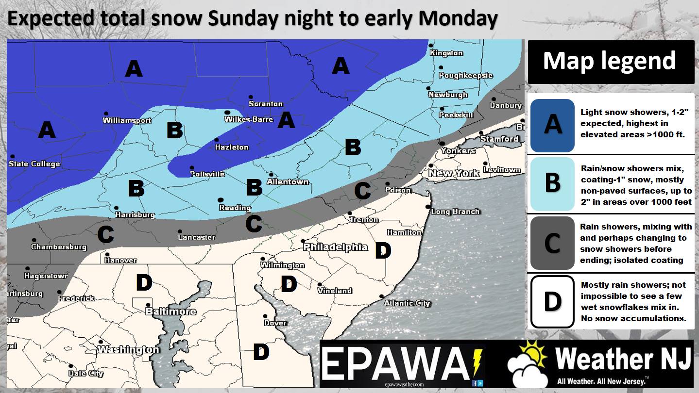
Click Here to See FULL SIZE Snow Map!
If you are having trouble viewing the above map, we suggest that you hold down on the image so that it saves to your device. You should then be able to view it in full screen. We’re exploring options for better displaying our impact maps on mobile devices but that’s the workaround for now.
In English: Precipitation is currently approaching from the W and should fall between midnight tonight and 8AM tomorrow morning. The higher elevations of NNJ (above 1000ft) have the best chance to see up to a few inches of snow accumulations. SNJ and especially coastal areas have the best chance to see all rain. CNJ and the lower elevations of NENJ could bounce back and forth between cold rain and a wintry mix depending on precipitation intensity. If more intense then it could change rain over to snow (precipitation brings colder air down). If less intense then cold rain is more likely. To be clear, we are not expecting wintry accumulation S of a line drawn from Trenton to Sandy Hook. Some non-accumulating snow mixed in? Maybe. This is a NNJ/NWNJ light snow event and cold rain for mostly everyone else. It is far from a big deal but could time poorly for the Monday AM commute for said areas. The sun should return for tomorrow. I’ll have the Monday-Friday outlook posted later tonight which will address the Arctic outbreak expected towards the end of the week. Have a great Sunday night and please be safe! JC
Jonathan Carr (JC) is the founder and sole operator of Weather NJ, New Jersey’s largest independent weather reporting agency. Since 2010, Jonathan has provided weather safety discussion and forecasting services for New Jersey and surrounding areas through the web and social media. Originally branded as Severe NJ Weather (before 2014), Weather NJ is proud to bring you accurate and responsible forecast discussion ahead of high-stakes weather scenarios that impact this great garden state of ours. All Weather. All New Jersey.™ Be safe! JC


LOCAL FORECAST | INTERACTIVE RADAR | LATEST NJ WEATHER ALERTS | WEDDING FORECAST| PRIVACY POLICY
© Copyright 2026 Weather NJ LLC. All Rights Reserved.
Some information that can be found on our website is provided by a private weather station and is not an officially recognized station for weather reporting. Though we always strive to achieve accurate reporting for our own use, it is important that you do NOT depend on the data provided here for any purpose.
