

Dec 5: Coastal Storm Update
Model guidance continues to suggest a strong coastal storm developing and impacting New Jersey early next week. Timing currently looks like Monday afternoon-evening through possibly Wednesday morning depending on how slow the system moves, or stalls. This system is looking warm for the I-95 corridor and points SE meaning mostly rain. Only points well NW of that have a chance for snowfall accumulations. My primary concern is along the coast as onshore winds and rain could spell beach erosion and tidal flooding.
We’re dealing with a cut off low that separates from the northern stream and interacts with a surface low that develops of the SE US coast. This presents a challenging forecast with potential for surprise either way (colder or warmer). In such a volatile environment, precipitation types and amounts are almost impossible to estimate at this point. All we know is that a storm probable. We still need to nail down the final track first so lets go right to the latest mid-range model guidance:
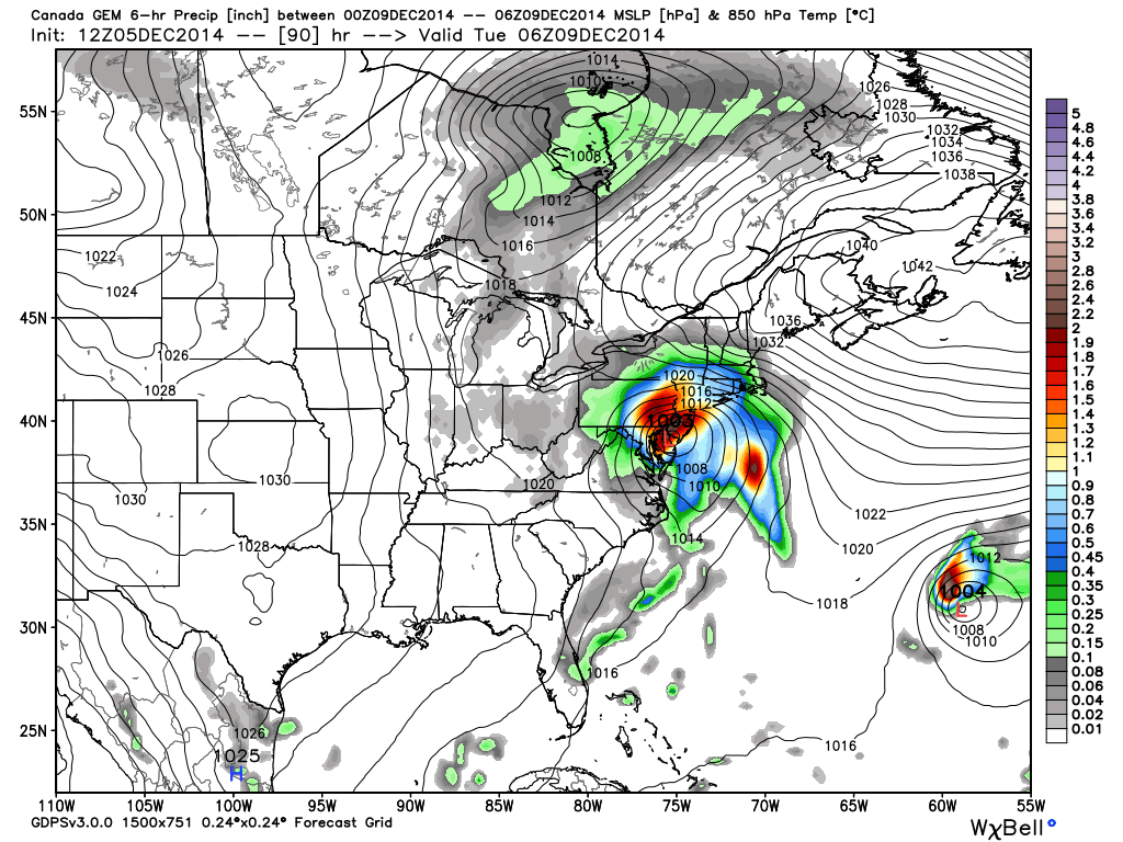
The 12Z Canadian model has shifted pretty far west compared to yesterday. It brings the low right over NJ/NYC which is way too far west and warm for snow along the coastal plain. Heck, that’s even getting toasty for NWNJ. You can clearly see that less interaction with the coastal low occurs. The primary concern as modeled would be coastal impact as gale force winds would couple with heavy precipitation just days after a full moon. This is the Canadian showing 850mb pressure and precipitation Monday night into early Tuesday morning. The system clears by Tuesday evening:
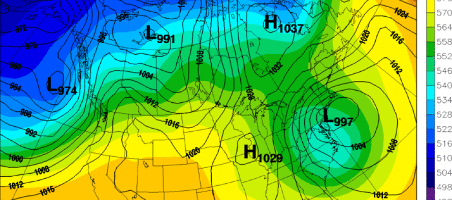
The next model I’d like to show is the 12Z UKMET (United Kingdom’s global operational model). It shows a very similar solution to the Canadian with the western shift but has a much slower system lasting well into Wednesday. This model likes a slower solution because it suggests more influence from the high pressure to the north:
The 12Z GFS is just lost. It’s been lost and it will probably continue to be lost until later this weekend. Right now, it’s one of the only models that suggest a weak storm out to sea. Perhaps it will get it’s act together when northern stream energy gets over land for better data sampling. The NCEP is also in the process of upgrading their model so it is what it is.
The 12Z European agrees with the Canadian and UKMET with a much closer low to land. It should be noted that the low pressure gets down to 988mb which is a pretty decent intensity for a coastal storm. In my past experience, the Canadian/UKMET/EURO combination is pretty lethal from this time range in regards to accuracy, especially if their ensembles continue to support their operational solutions.
In English: Expect rain and strong NE winds for the lower 2/3 of New Jersey next Monday-Wednesday. High winds, coastal flooding and beach erosion are my primary concerns. Only NWNJ has a chance at snow but it’s still too soon for amounts. Snow looks better with this system for NEPA and the Catskills of NY. At this point a colder storm would be a wild card solution. I’ll continue to monitor. Be safe! JC
Model images used with permission from Dr. Ryan Maue of WeatherBell Analytics and UQAM Weather Center.
ss
Jonathan Carr (JC) is the founder and sole operator of Weather NJ, New Jersey’s largest independent weather reporting agency. Since 2010, Jonathan has provided weather safety discussion and forecasting services for New Jersey and surrounding areas through the web and social media. Originally branded as Severe NJ Weather (before 2014), Weather NJ is proud to bring you accurate and responsible forecast discussion ahead of high-stakes weather scenarios that impact this great garden state of ours. All Weather. All New Jersey.™ Be safe! JC


LOCAL FORECAST | INTERACTIVE RADAR | LATEST NJ WEATHER ALERTS | WEDDING FORECAST| PRIVACY POLICY
© Copyright 2026 Weather NJ LLC. All Rights Reserved.
Some information that can be found on our website is provided by a private weather station and is not an officially recognized station for weather reporting. Though we always strive to achieve accurate reporting for our own use, it is important that you do NOT depend on the data provided here for any purpose.
