

Dec 6: Coastal Storm a GO!
We’re just about 72 hours from a coastal storm impacting the coastal mid-Atlantic and NE US. High winds and heavy rainfall are expected for the first half of the storm before precipitation changes to wintry form from NW to SE. While the storm track is beginning to lock onto what’s known as a “coastal hugger” there is uncertainty in timing. The low will either pass by at a consistent speed in what’s known as a “progressive flow” or stall out and possibly even retrograde over New Jersey before moving out. The former is just a “coastal storm” and currently modeled by the GFS/Canadian. It would mean a Monday night-Tuesday afternoon storm. The latter would make it a nor’easter and is currently modeled by the Euro/UKMET. That would mean a Monday night-Wednesday morning storm.
Let me be crystal clear that snowfall accumulations will not be the main headline. Parts of PA and NY State could get hit pretty hard but not in New Jersey. This is a warm system for the lower 2/3 of New Jersey. NWNJ has the best chance for rain changing to snow before ending. Given the timing uncertainty mentioned above, the outcome could mean the difference between trace amounts and significant accumulations. Away from the ocean and below 1000 feet in elevation should just see a rainy and windy period.
The main headline will be coastal impact. Should the faster solution verify then coastal impact will just consist of minor beach erosion with run of the mill flooding. Should the slower solution verify then the entire Jersey Shore is looking at prolonged E/NE flow which could spell coastal flooding issues, especially during the multiple high tides that will occur. Heavy rainfall would have trouble draining on barrier islands.
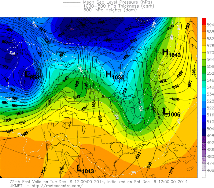
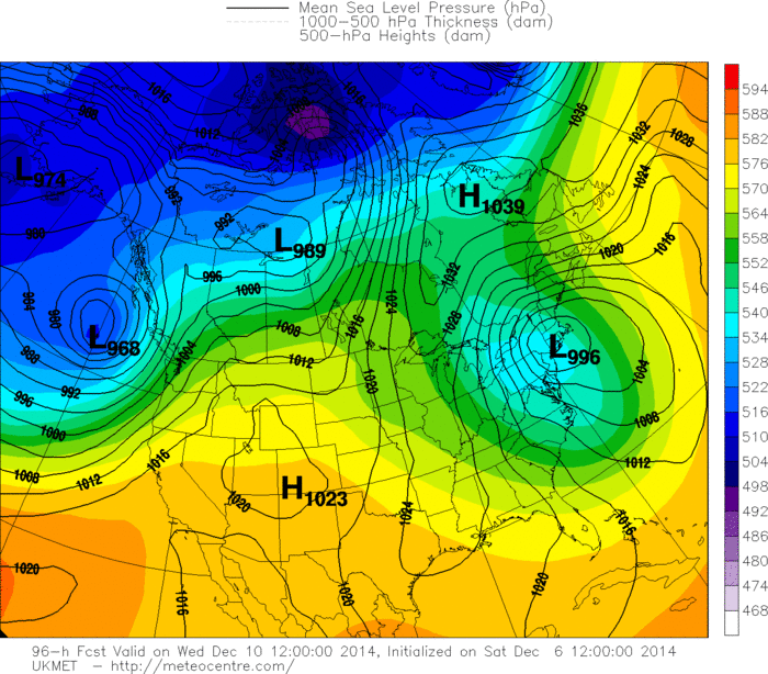
The synoptic setup in my opinion favors a slower solution. A string of high pressure systems look like they are going to form what’s known as a “banana high” from the Great Lakes through E. Canada and into the N. Atlantic Ocean. This should slow the system down. Also, while the short range models are still out of range, their first 48-hour reliable periods are matching the Euro/UKMET initializations. Let’s look at the three 24-hour UKMET model frames that surround this system:
Tuesday Morning
Wednesday Morning
Thursday Morning
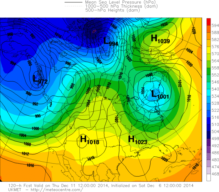
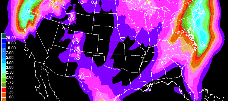
You can see the low pressure center move very close to the New Jersey coast as it passes by. Given that proximity and low pressure intensity, the coast should see gale force winds. The National Weather Service HPC is expecting the following liquid precipitation amounts over the next 5 days. Keep in mind this includes probably about .50-1 inch of today’s rainfall:
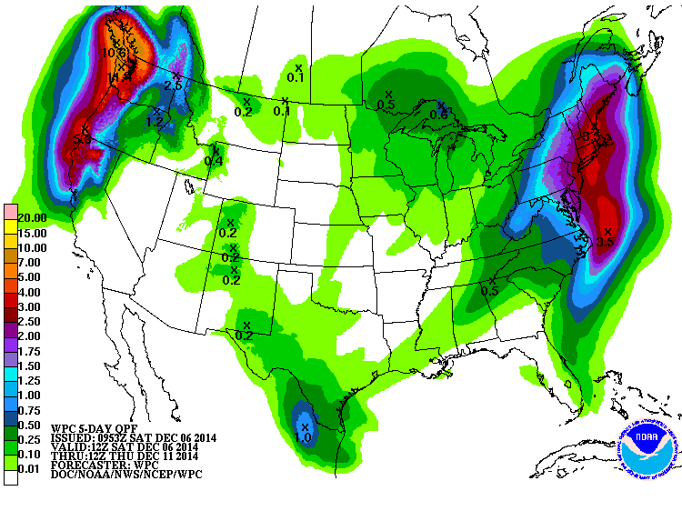
In English: Expect rain all day today and overnight. It should clear for a cool but dry Sunday. E/NE winds will gradually increase tomorrow heading into Monday. Rain and wind will then move in from Monday night until at least Tuesday and possibly Wednesday morning. Rain should be heavy with strong winds along the coast. Watch out for flooding during high tide(s). Rain could end as snow for NWNJ first before working its way towards I-95 as the storm system departs. First accumulation map will be out tomorrow evening. Be safe! JC
Jonathan Carr (JC) is the founder and sole operator of Weather NJ, New Jersey’s largest independent weather reporting agency. Since 2010, Jonathan has provided weather safety discussion and forecasting services for New Jersey and surrounding areas through the web and social media. Originally branded as Severe NJ Weather (before 2014), Weather NJ is proud to bring you accurate and responsible forecast discussion ahead of high-stakes weather scenarios that impact this great garden state of ours. All Weather. All New Jersey.™ Be safe! JC


LOCAL FORECAST | INTERACTIVE RADAR | LATEST NJ WEATHER ALERTS | WEDDING FORECAST| PRIVACY POLICY
© Copyright 2025 Weather NJ LLC. All Rights Reserved.
Some information that can be found on our website is provided by a private weather station and is not an officially recognized station for weather reporting. Though we always strive to achieve accurate reporting for our own use, it is important that you do NOT depend on the data provided here for any purpose.
