

Dec 7: Coastal Storm Update and Storm Impact Map
The following storm impact map represents my current thoughts on the approaching coastal storm this week:
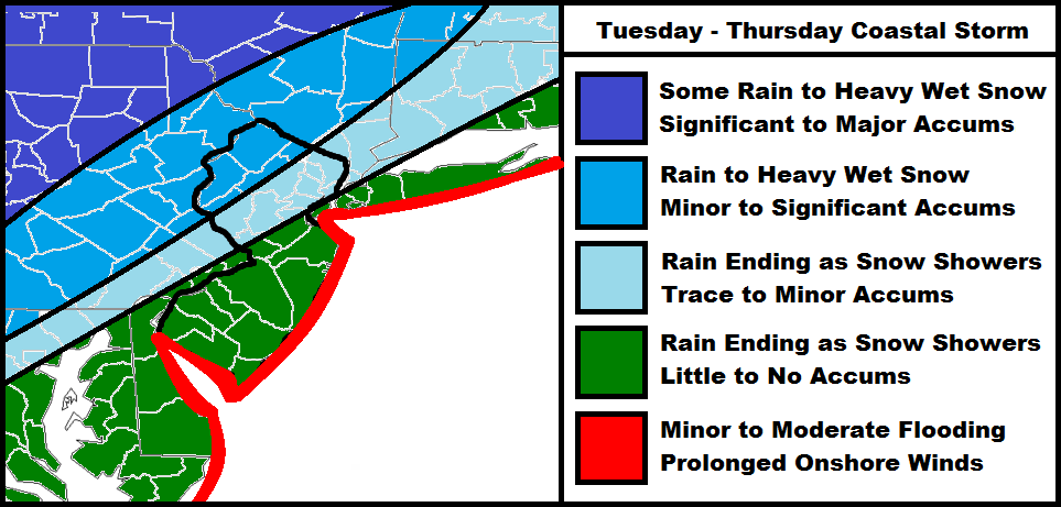
Timing looks like late Monday night through possibly Thursday morning. The longer duration is due to the coastal low stalling and possibly even retrograding off the Jersey coast as a nor’easter before moving out. It’s important to note that easterly winds will develop well ahead of the storm system. High tides could start impacting the barrier islands and back bays of coastal NJ as early as tomorrow morning. As I’ve been expressing this week, coastal impact is my primary concern despite significant accumulations being possible in NWNJ. I’ll release a final call map tomorrow including expected snow accumulations in inches. For now, this map is my best representation. Be safe! JC
Jonathan Carr (JC) is the founder and sole operator of Weather NJ, New Jersey’s largest independent weather reporting agency. Since 2010, Jonathan has provided weather safety discussion and forecasting services for New Jersey and surrounding areas through the web and social media. Originally branded as Severe NJ Weather (before 2014), Weather NJ is proud to bring you accurate and responsible forecast discussion ahead of high-stakes weather scenarios that impact this great garden state of ours. All Weather. All New Jersey.™ Be safe! JC


LOCAL FORECAST | INTERACTIVE RADAR | LATEST NJ WEATHER ALERTS | WEDDING FORECAST| PRIVACY POLICY
© Copyright 2025 Weather NJ LLC. All Rights Reserved.
Some information that can be found on our website is provided by a private weather station and is not an officially recognized station for weather reporting. Though we always strive to achieve accurate reporting for our own use, it is important that you do NOT depend on the data provided here for any purpose.
