

Dec 7: First Call Snow Map for Saturday
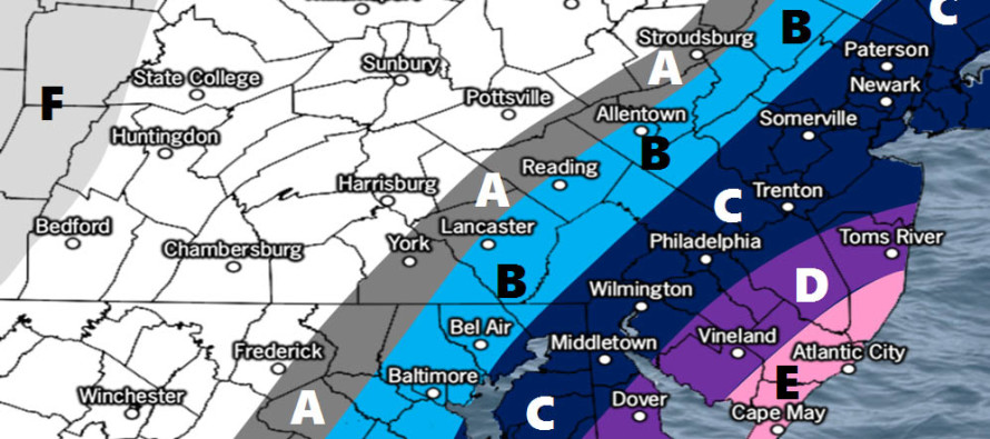

Click here to view full resolution snow map!
Discussion: The biggest trends I’ve seen over the last few days are timing, strength and NW-precipitation extent. This is now a Saturday event. Flurries could possibly begin late Friday night but the meat and potatoes of the event should occur between Saturday morning and Saturday evening. The low intensity is expected to be between 990-995mb when passing NJ closer to the coast instead of ~1000mb further offshore. Given the evolving change in speed between the shortwaves involved (northern and southern streams), the entire axis of the overall trough is now expected to be tilted more towards neutral rather than positive. The specific shortwave reasoning behind this is a slower southern jet. Ridging to the N/NE of Bermuda should reciprocate this idea allowing for a SW to NE track along the offshore boundary instead of a W/SW to E/NE track. With that said we are now expecting wintry precipitation to reach further NW beyond the I-95 corridor/NJTP. Areas away from the immediate coast in SENJ (along and just SE of I-95/NJTP) have the best chance to see jackpot accumulations from this event.
Timing: The timing change now bring marginal surface temperatures to the game. If this event was overnight, Friday into Saturday, then there would be less of an issue. But given that most snowfall will now occur while the sun is up during the warmest part of the day, there should be less accumulations on paved surfaces especially treated roads. Natural surfaces (grass, trees, etc.) have a much better chance for snowfall to accumulate during daylight hours. With such an early sunset this time of year, road accumulation could be possible just after sundown as temperatures fall. Snow should arrive from SE to NW early Saturday morning (backing in off the ocean). Snowfall should taper off from W to E between Saturday afternoon (WNJ) and late Saturday evening (ENJ).
Coastal Concerns: Ocean temperatures are between 51-53F (from Sandy Hook to Cape May) which brings an even more marginal temperature profile to the immediate coast meaning less chances for accumulation and possibly even a snow/rain mix at times. Marine tidal guidance is suggesting minor to the lower end of moderate chances for coastal flooding. We actually saw higher water levels this morning than what should occur on Saturday. I’m not seeing much of a wind-driven storm surge given low intensity and proximity to the coast. But there will be a passing coastal system out there so tidal levels are at least expected to increase some during peak-storm hours with most E winds occurring offshore.
The strongest winds should occur after the system pulls away (after precipitation shuts off). Therefore we can expect a cold Saturday night through Monday as NW winds take over. We can then expect even colder conditions for Tuesday-Thursday as Arctic air mass settles in. We might see low-impact from a clipper system Tuesday before NW winds resume cranking with bottomed-out upper level temperatures. I’m seeing HIGHS in the 20s for NWNJ on Wednesday. Even places like Atlantic City should struggle to climb above 30 mid next week.
In English: It’s going to snow between early Saturday morning and Saturday evening. You might see flurries start as early as late Friday night but most snowfall should occur on Saturday. The above snow map represents our first call on expected snowfall accumulations. There is still room for trending either way which will be reflected in our final snow map tomorrow. As indicated in the map, extreme SENJ is subject to rain mixing in with snow. It is important to note that natural surfaces (grass, trees, etc) will have an easier time accumulating than paved surfaces, especially treated major roads…until dusk. Any snowfall that occurs after sundown on Saturday will likely stick easier. Have a great night and please be safe! JC
For comprehensive and interactive hyper-local analysis that goes way above and beyond the detail of this public forecast, check out our premium services.
Jonathan Carr (JC) is the founder and sole operator of Weather NJ, New Jersey’s largest independent weather reporting agency. Since 2010, Jonathan has provided weather safety discussion and forecasting services for New Jersey and surrounding areas through the web and social media. Originally branded as Severe NJ Weather (before 2014), Weather NJ is proud to bring you accurate and responsible forecast discussion ahead of high-stakes weather scenarios that impact this great garden state of ours. All Weather. All New Jersey.™ Be safe! JC


LOCAL FORECAST | INTERACTIVE RADAR | LATEST NJ WEATHER ALERTS | WEDDING FORECAST| PRIVACY POLICY
© Copyright 2026 Weather NJ LLC. All Rights Reserved.
Some information that can be found on our website is provided by a private weather station and is not an officially recognized station for weather reporting. Though we always strive to achieve accurate reporting for our own use, it is important that you do NOT depend on the data provided here for any purpose.
