

Dec 8: Buckle Up Jersey!

A strong coastal storm/nor’easter will impact the region starting tonight and lasting through possibly Thursday morning. Here’s my Snow/storm impact map:
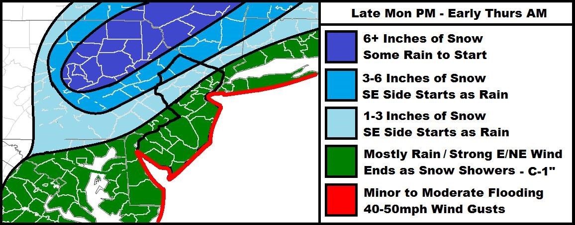
The first part of the storm will occur tonight through tomorrow evening. Precipitation will move in from the south overnight and gradually increase in intensity through tomorrow. Since the ground is colder than expected, watch out for ice overnight. Rain and wind will both be heavy at times tomorrow, especially along the coast. Couple the wind-driven rain with tidal surge during high tides (tomorrow morning and tomorrow evening), and there could be problems for the barrier islands and back bays of coastal New Jersey. Coastal NJ OEM should continue to monitor.
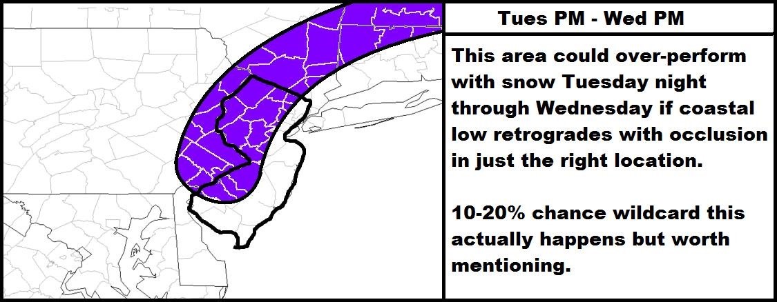
The next part of the storm will occur tomorrow night and well into Wednesday as the coastal storm retrogrades and begins transferring away. Winds should be stiff out of the N/NW during this back side of the system. There are some pretty interesting dynamics involved so with that being said, I offer the following wildcard situation. This is a low confidence possibility and should therefore not be expected. I would just have it in the back of your mind in case this system does over-perform on the colder back side:
Since the low will be so slow moving, it will take a while to clear out. Through Thursday, winds will be strong out of the NW and could deliver on-and-off snow showers/squalls to most of the state (maybe rain for immediate coast). The low will be over New England but the strong flow associated with the western side of it’s cyclonic flow will mean gusty winds at the surface. Friday could be the first precipitation-free day.
In English: Expect heavy wind-driven rain tonight through tomorrow evening (could start as sleet/freezing rain). Expect rain to change to snow from NW to SE tomorrow night and last well into Wednesday. NW of the Turnpike would see more snow than SE of the Turnpike. Precipitation tapers off but with remnant snow/rain showers lasting into Thursday. It’s now-casting time. Stay warm stay dry and as always, be safe! JC
Jonathan Carr (JC) is the founder and sole operator of Weather NJ, New Jersey’s largest independent weather reporting agency. Since 2010, Jonathan has provided weather safety discussion and forecasting services for New Jersey and surrounding areas through the web and social media. Originally branded as Severe NJ Weather (before 2014), Weather NJ is proud to bring you accurate and responsible forecast discussion ahead of high-stakes weather scenarios that impact this great garden state of ours. All Weather. All New Jersey.™ Be safe! JC


LOCAL FORECAST | INTERACTIVE RADAR | LATEST NJ WEATHER ALERTS | WEDDING FORECAST| PRIVACY POLICY
© Copyright 2025 Weather NJ LLC. All Rights Reserved.
Some information that can be found on our website is provided by a private weather station and is not an officially recognized station for weather reporting. Though we always strive to achieve accurate reporting for our own use, it is important that you do NOT depend on the data provided here for any purpose.
