

Dec 8: Light Snow for NWNJ
Discussion: We’re now under the NW flow that occurs in the upper levels on the back of a trough. A very weak upper-level disturbance, and associated surface low in Canada, is going to send a piece of the energy from the low center towards NJ overnight into Wednesday morning.
This could produce light snowfall for NJ with a strong favoring of NWNJ elevations. The highest elevations of Sussex County always jackpot on events like this. So, for that specific geographic area a few inches of snow are possible. For the rest of NJ in that area (N of I-78 and NW of I-287, anything from a coating to an inch is possible. Once you extend downward into NENJ and CNJ, just non-accumulating flurries is about all I would expect. Perhaps a dusting on natural surfaces. I don’t see much happening SE of the NJ Turnpike/I-95 corridor.
This very light wintry event should move into NWNJ just after midnight tonight and clear out by late Wednesday morning—making 3-8am the most likely hours of snowfall. Here’s the latest expected snowfall map from the HRRR model via WeatherBell Analytics:
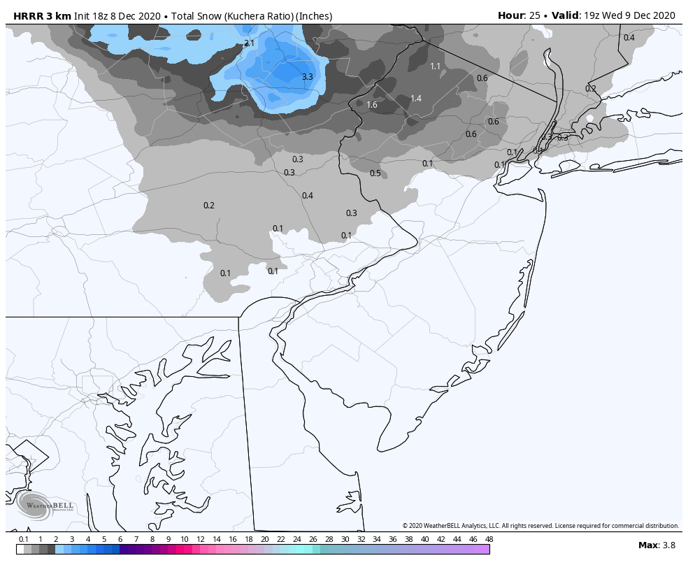
In English: Snow is possible for the colder NW regions of NJ Wednesday morning. A light event with only a few inches at most in the highest elevations. Otherwise, a conversational coating more likely NW of the Turnpike in general. Just please consider that many roads will likely be untreated, and it only takes a thin coating to make it slick. Little-to-no issues are expected SE of the Turnpike / S of I-78. Recommend allowing a little more travel time (for those N of I-78 / NW of I-287) between 3-8am. Please be safe! JC
Download the free Weather NJ mobile app on Apple or Android. It’s the easiest way to never miss Weather NJ content. Our premium services go even further above and beyond at the hyper-local level. Get your merch on at the KABOOM shop in time for the holidays.
Jonathan Carr (JC) is the founder and sole operator of Weather NJ, New Jersey’s largest independent weather reporting agency. Since 2010, Jonathan has provided weather safety discussion and forecasting services for New Jersey and surrounding areas through the web and social media. Originally branded as Severe NJ Weather (before 2014), Weather NJ is proud to bring you accurate and responsible forecast discussion ahead of high-stakes weather scenarios that impact this great garden state of ours. All Weather. All New Jersey.™ Be safe! JC


LOCAL FORECAST | INTERACTIVE RADAR | LATEST NJ WEATHER ALERTS | WEDDING FORECAST| PRIVACY POLICY
© Copyright 2026 Weather NJ LLC. All Rights Reserved.
Some information that can be found on our website is provided by a private weather station and is not an officially recognized station for weather reporting. Though we always strive to achieve accurate reporting for our own use, it is important that you do NOT depend on the data provided here for any purpose.
