

Dec 8: Midweek Snow Likely
Discussion: Departing high pressure in the Atlantic Ocean will help pump and E US warm sector with a Great Lakes-tracking low. That’s going to keep the Mid-Atlantic mild and rainy for Monday-Tuesday with high temperatures pushing 60 at times.
On Tuesday evening high pressure will track behind the stalled boundary which used to be the cold front of the Great Lakes low. The front-side of the anti-cyclonic flow will inject cold into and push the boundary through New Jersey. While this could chill down the low-mid levels I don’t like how the surface and upper-levels look regarding accumulating snowfall. The surface is going to be very mild and wet from the anomalous Monday-Tuesday warmth. It will be the last layer to crash to near-freezing or below and that could very well be after precipitation ends. The upper levels indicate geopotential heights of 540dam or greater over New Jersey throughout the entire event. That’s never a good look for snow but the upper-levels are above where the precipitation gets made. Sometimes snow support can make sense under such conditions but in most cases it doesn’t.
You might be hearing the term anafrontal. This simply means precipitation created from the lifting ahead of the front. It’s a wet front as opposed to katafrontal which is a dry frontal passage due to sinking/inhibition ahead of the front.
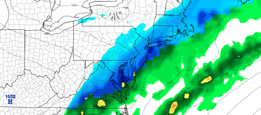
The 850-700mb layers however look to crash below freezing Tuesday night into Wednesday morning. This should be from that anti-cyclonic flow of the trailing high (to our NW) at correlating layers. Since these are the critical layers for wintry precipitation creation there’s a decent amount of snow that could fall in this time period. But with the warmer surface I could see a lot of white rain (snow that melts on contact to most paved and manmade surfaces). Grassy surfaces and parked cars that haven’t been running in a while do better with stickage. I think this will be the case for most areas S of I-80 and SW of I-287 (lower 2/3 of NJ). Areas N of I-80 and NW of I-287 have the best chance to see light accumulations due to temperatures having the best chance to crash below freezing. I would allow for maybe light accumulations down to I-95/NJTP.
Now let’s talk some dynamics. With a warmer surface under the colder low-mid layers aloft we could see some convective precipitation. This system is a progressive flat wave so any kind of coastal low enhancement off OBX could enhance precipitation along the general boundary. In either case the precipitation could be heavy enough to bring colder air down to the surface. When this happens you get localized instances of roads sticking. We saw this in areas like Brick and Freehold last week while surrounding areas saw more of a white rain.
In English: It should be mild and rainy for most of Monday and Tuesday. Heavy rainfall and gusty winds are possible at times. Between Tuesday evening and about noon on Wednesday temperatures should drop and rain should change to snow. NWNJ has the best chance for accumulations. Light accumulations could make it down to I-95/NJTP. The rest of New Jersey (along and SE of I-95/NJTP) are likely looking at conversational white rain at this point due to above-freezing surface temperatures during the snowfall. I’ll be updating accordingly. Have a great week and please be safe! JC
Download the new free Weather NJ mobile app on Apple and/or Android. It’s the easiest way to never miss Weather NJ content. Our premium services go even further above and beyond at the hyper-local level. Looking for industrial-caliber long-range forecasting data that I personally recommend? Check out WeatherTrends360! Visit the Weather NJ Kaboom Shop for hoodies, tees and infant onesies.
Jonathan Carr (JC) is the founder and sole operator of Weather NJ, New Jersey’s largest independent weather reporting agency. Since 2010, Jonathan has provided weather safety discussion and forecasting services for New Jersey and surrounding areas through the web and social media. Originally branded as Severe NJ Weather (before 2014), Weather NJ is proud to bring you accurate and responsible forecast discussion ahead of high-stakes weather scenarios that impact this great garden state of ours. All Weather. All New Jersey.™ Be safe! JC


LOCAL FORECAST | INTERACTIVE RADAR | LATEST NJ WEATHER ALERTS | WEDDING FORECAST| PRIVACY POLICY
© Copyright 2026 Weather NJ LLC. All Rights Reserved.
Some information that can be found on our website is provided by a private weather station and is not an officially recognized station for weather reporting. Though we always strive to achieve accurate reporting for our own use, it is important that you do NOT depend on the data provided here for any purpose.
