

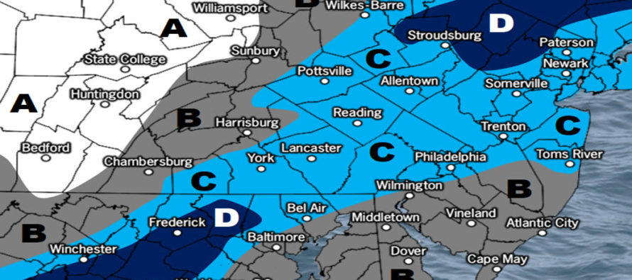
Dec 9: Snow Map for Tues PM-Wed AM
Discussion: We’re now in the warm sector of the Great Lakes-tracking low. That’s why we are mild and wet today under the influence of S/SW flow. This will continue overnight and through most of Tuesday with on-and-off periods of rainfall and breezy/gusty winds.
Upstream high pressure will then drive a cold front through the low-mid precipitation layers between Tuesday night and Wednesday morning changing rain to snow through New Jersey from NW to SE. Surface temperatures however are expected to inhibit snow accumulations for many areas especially on roadways and especially along and SE of I-95/NJTP. Only NWNJ should dip below freezing. Areas down to I-95 should get near-freezing but no guarantee they will dip below unless under a strong fronto meso band of snow. Areas along and SE of I-95/NJTP will likely stay above freezing at the surface.
Regardless of surface temperatures inhibiting accumulations on paved surfaces, the low-mid layers will likely snow Tuesday night into Wedensday morning and possibly decently at times. Again I think this will be white rain at best along and SE of I-95/NJTP. White rain, for those who missed the article yesterday, is snow that falls and melts on contact.
Since NWNJ (NW of I-95/NJTP) has the best chance to drop to near-freezing or below-freezing said areas have the best chance for light accumulations even on some paved surfaces and minor roadways. Because this is a flat and progressive wave-like frontal passage there are no coastal flooding or high wind threats to worry about. The following snow map is our initial best guess on what to expect.
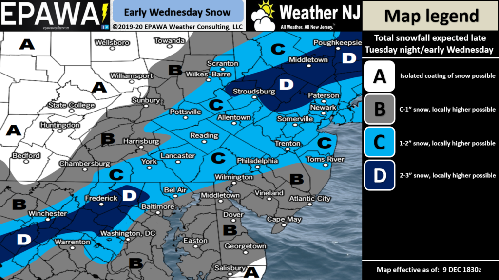
Click here to view full-resolution snow map.
The weekend storm signal (what I’ve been tracking as ~Dec 14-16) is still very much alive but looks warm. Currently Saturday, December 14 looks wet and windy. The signal does not look wintry at the moment due to lack of cold air injection from the N stream. The low will likely pass just to the NW of New Jersey instead of where it would need to be for snow (SE of NJ). I will continue to monitor however in case it trends colder.
In English: We’re mild and wet now through Tuesday afternoon/evening. Temps then fall Tuesday evening through Wednesday morning and change rain to snow. The above snow map represents our initial best guess at expectations. Zone B will likely be on natural surfaces only. Zone C should be mostly on natural surfaces (some side streets). Zone D has the best chance for accumulations to stack on side streets and some minor roadways with highways likely staying wet but still possibly slippery. We then dry out later Wednesday through Friday. The weekend storm signal is still there for Saturday but looks like rain and wind not snow and wind. Have a great evening and please be safe! JC
Download the new free Weather NJ mobile app on Apple and/or Android. It’s the easiest way to never miss Weather NJ content. Our premium services go even further above and beyond at the hyper-local level. Looking for industrial-caliber long-range forecasting data that I personally recommend? Check out WeatherTrends360! Visit the Weather NJ Kaboom Shop for hoodies, tees and infant onesies.
Jonathan Carr (JC) is the founder and sole operator of Weather NJ, New Jersey’s largest independent weather reporting agency. Since 2010, Jonathan has provided weather safety discussion and forecasting services for New Jersey and surrounding areas through the web and social media. Originally branded as Severe NJ Weather (before 2014), Weather NJ is proud to bring you accurate and responsible forecast discussion ahead of high-stakes weather scenarios that impact this great garden state of ours. All Weather. All New Jersey.™ Be safe! JC


LOCAL FORECAST | INTERACTIVE RADAR | LATEST NJ WEATHER ALERTS | WEDDING FORECAST| PRIVACY POLICY
© Copyright 2026 Weather NJ LLC. All Rights Reserved.
Some information that can be found on our website is provided by a private weather station and is not an officially recognized station for weather reporting. Though we always strive to achieve accurate reporting for our own use, it is important that you do NOT depend on the data provided here for any purpose.
