

Dec 12: Snow Event(s) Detected
Discussion: This discussion is for two separate disturbances expected to occur this coming week. The first is on Monday (Dec 14) and the second Wednesday into Thursday (Dec 16-17).
For the first event on Monday, we have a trough anchored in N Canada that’s swinging two pieces of energy along through our region. The pieces are on separate jets but are phasing into the overall deep trough. This energy should come through our region fairly unorganized but eventually intensify into a strong Upper Level Low (ULL) later in the week.
For Monday the surface low track is very flat and progressive without blocking established. Also, much of NJ should be above freezing Monday heading in. There will be colder air immediately available to the NW but that is expected to gradually trickle in through the precipitation (from NW to SE). The changeover to snow might only happen along and NW of the Turnpike. Those near and SE of the Turnpike are likely looking at mostly rain from the Monday event with maybe some ending snow struggling to accumulate. The highest elevations of NWNJ are always subject to a few more inches but here’s our impact map for Monday:
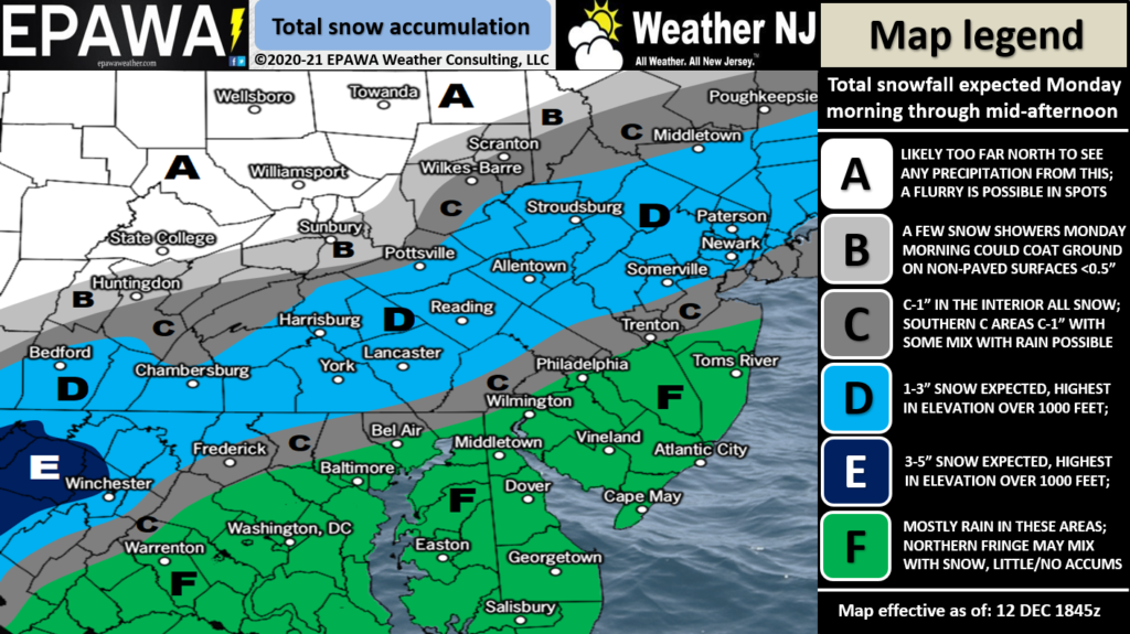
Click here to see full resolution impact map!
For the second event Wednesday-Thursday, the energy from the first event is expected to set up a 50/50 blocking low to hold high pressure over the NE US and further slow the coastal low. Because of offshore upper-level SW flow, this low will want to turn N a little bit more, following the path under the best increasing Positive Vorticity Advection (PVA)/divergence, which is why it’s expected to be a stronger surface low. The high pressure over NE US would then fight back with a wall of cold running through most of NJ.
With that said, SE NJ is always on the hook for marine-influenced milder temperatures. Especially during onshore wind components over December ocean water. So, I do anticipate surface temperature profile problems for at least a part of SENJ. This would mean rain inhibiting snow totals. For these areas (SENJ) this is looking like a rain to snow event.
But for NNJ and much of CNJ (W of I-295/N if I-195) – maybe further SE, this second system is starting to look like a legit snowstorm with Kaboom potential. NNJ (All of NJ N of I-78) would be the jackpot of the latest model guidance. This includes a lot of Philadelphia and most of New York City metropolitan areas. We have some time for that to shift around but there is tremendous consensus right now 4 days out.
In English: Two systems capable of producing snow and rain are likely this coming week. A weaker one on Monday and a more powerful one Wednesday into Thursday. For both systems, NNJ is favored for the most snowfall. For both systems, a snow/rain line will likely keep at least a portion of SNJ/SENJ as mostly rain. Where that snow rain line sets up is a little more certain for Monday (along I-95/NJTP) but less certain for Wednesday-Thursday.
Monday timing: Light rain starts statewide by 8am, NNJ, and parts of CNJ, changeover to snow between late-morning and early-afternoon, all precipitation ends by or around sunset. See above impact map for estimated snow totals. If precipitation rates are heavier than snow totals could rise slightly along I-95 and for NWNJ elevations.
Wednesday-Thursday timing: Most model guidance is agreeing on a general noon Wednesday to noon Thursday period for NJ give or take a few hours. Per the latest model guidance, all of NNJ and most of CNJ would likely start and stay all plowable snow. SENJ, possibly some parts of SWNJ and ECNJ, would likely deal with periods of rain before changing over to snow. Again, that’s how it looks right now. I need 24 more hours to look at the data and live observations before committing to a more detailed forecast (amounts/locations/etc.). The first snow map for the second system will likely be tomorrow (Sunday).
Have a great rest of your Saturday and please be safe! JC
Download the free Weather NJ mobile app on Apple or Android. It’s the easiest way to never miss Weather NJ content. Our premium services go even further above and beyond at the hyper-local level. Get your merch on at the KABOOM shop in time for the holidays.
Jonathan Carr (JC) is the founder and sole operator of Weather NJ, New Jersey’s largest independent weather reporting agency. Since 2010, Jonathan has provided weather safety discussion and forecasting services for New Jersey and surrounding areas through the web and social media. Originally branded as Severe NJ Weather (before 2014), Weather NJ is proud to bring you accurate and responsible forecast discussion ahead of high-stakes weather scenarios that impact this great garden state of ours. All Weather. All New Jersey.™ Be safe! JC


LOCAL FORECAST | INTERACTIVE RADAR | LATEST NJ WEATHER ALERTS | WEDDING FORECAST| PRIVACY POLICY
© Copyright 2026 Weather NJ LLC. All Rights Reserved.
Some information that can be found on our website is provided by a private weather station and is not an officially recognized station for weather reporting. Though we always strive to achieve accurate reporting for our own use, it is important that you do NOT depend on the data provided here for any purpose.

 Detected)