

Discussing the Rest of February


It’s time to harness WeatherTrends360 technology and look at the rest of February 2019. WeatherTrends360 algorithms are documented with an 84% verification rate and are based on oceanic water cycles, time table series and very complex mathematics. The best takeaway from this data are general trends (cool vs warm, rainy vs dry, etc). I’m always hesitant to forecast specific surface conditions (rainfall amounts, snowfall amounts, winds, etc) beyond the 7 -day forecasting period. But temperature and precipitation trends are what WeatherTrends360 does best with their proprietary mathematical analysis derived from over 150 years of reactive pattern data. For this reason, let’s call this a long-range discussion of expectations rather than a locked-in long-range forecast.
The following diagram is calculated for the meat and potatoes of New Jersey in general. Please keep in mind that micro-climate influences can vary. NWNJ elevations, for example, will likely end up ~5-10 degrees colder than what is shown. SENJ, especially the immediate coast, will likely end up ~5-10 degrees warmer than what is shown. But for most of New Jersey between this diagram should suffice in getting the point across.
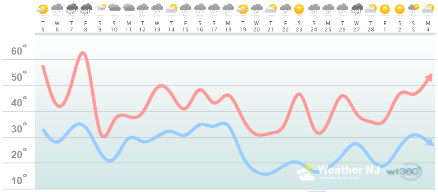
Discussion: The mild spike in temperatures for this Thursday-Friday (Feb 7-8) jumps out as highly anomalous. Just like these past few days conditions are expected to remain mild for the rest of this week (aside from a cold-moderated Wednesday Feb 6). Temperatures should then crash for the weekend (back to winter reality). We then have two opportunities for snow next week. The first looks very light on Monday (Feb 11). The second looks stronger for Wednesday (Feb 13). It’s a little too early for details but the Feb 13 storm signal is still very much alive. Temperatures will likely be too warm if precipitation falls during daylight hours but cold enough overnight to support snow. I imagine we’ll be tracking that with more detail by this weekend. Outside of the Feb 11 and 13 snow signals I’m not seeing anything else special through about Feb 19. Feb 19-28 then looks colder overall but still with a few days where temps spike into the 40s. Overnight lows however speak for themselves on the above diagram. Feb 24-27 looks like the best shot for precipitation within this period. If you would like to input your own zip code and have a chart like the one above generated please click here.
In English: Even though the coldest conditions of the season are likely behind us there’s still a lot of winter left before March 20. February statistically features the most amount of NJ snow storms and there are at least a few chances for such. Light snow is expected Monday Feb 11 and then something stronger for Wednesday Feb 13. The wildly polar temperature fluxes are likely finished once temperatures drop back to “normal winter cold” this weekend. After that we’ll likely deal with near-average temperatures for February with above-average precipitation. If the lousy timing persists then we’ll continue fluctuating between warm/wet and cold/dry. If precipitation and temperature time right then we’ll be looking at snow. It’s that simple. I’ll heavily track and blog about any snow signals within a 7-day forecasting period. For beyond 7 days I can’t recommend WeatherTrends360 enough. Everyone have a great rest of your February and please be safe! JC
Jonathan Carr (JC) is the founder and sole operator of Weather NJ, New Jersey’s largest independent weather reporting agency. Since 2010, Jonathan has provided weather safety discussion and forecasting services for New Jersey and surrounding areas through the web and social media. Originally branded as Severe NJ Weather (before 2014), Weather NJ is proud to bring you accurate and responsible forecast discussion ahead of high-stakes weather scenarios that impact this great garden state of ours. All Weather. All New Jersey.™ Be safe! JC


LOCAL FORECAST | INTERACTIVE RADAR | LATEST NJ WEATHER ALERTS | WEDDING FORECAST| PRIVACY POLICY
© Copyright 2026 Weather NJ LLC. All Rights Reserved.
Some information that can be found on our website is provided by a private weather station and is not an officially recognized station for weather reporting. Though we always strive to achieve accurate reporting for our own use, it is important that you do NOT depend on the data provided here for any purpose.
