

Feb 10: Watching Two Snow Possibilities
We’re now in the heart of peak snow season in the mid-Atlantic US. Hours of sunlight are increasing daily by minutes but coastal ocean sea surface temperatures are bottoming out for the year in the upper 30s. This is a big reason why December snow storms rarely pan out for the coast. The ocean is still in the 40s/50s which melts everything during onshore flow. With colder current sea surface temperatures, that affecting characteristic is buffered.
We have a solid Arctic blast on the way which will be ushered in by the first disturbance (this Thursday-Friday) and further intensified by the second disturbance (this Saturday-Sunday). When these lows pull away from the east coast, temperatures will crash at the assistance of Arctic high pressure dropping southward over the Great Lakes. The coldest period looks like Sunday-Monday with temperatures WAY below average for this time of year.
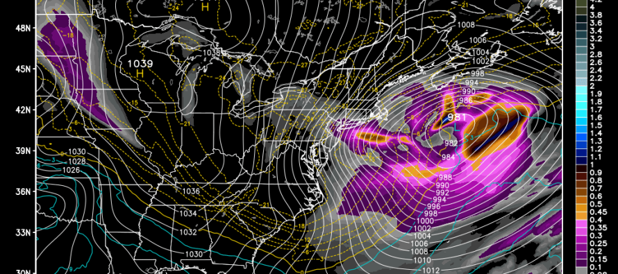
Both of these upcoming wintry possibilities are thread-the-needle scenarios. They involve clipper systems that come out of Canada and then transfer to the ocean off the coast of Delmarva/OBX. The upper-level support for both of these systems looks pretty good with solid captures, closed-off energy and negative tilting of the 500mb trough. The problem is timing—when these upper level dynamics happen and extrapolate to the surface. If this happens earlier then New Jersey could see significant to major snowfall. If this happens later then New Jersey is left with nuisance wintry precipitation. The difference of just 3-4 hours (a few hundred miles) in timing could result in such a spread of solutions. That’s pretty incredible when considering that we’re tracking these systems 4-7 days out (thousands of miles away).
Another curve-ball you might start hearing about is called an inverted trough. The GFS and Euro are both indicating this possibility for the Saturday night-Sunday event. An inverted trough is an area of low pressure that extends westward away from the center of the surface low pressure system. This occurs under a cold pool of air (which we’ll have at 700mb-500mb). The problem is that forecasting these kind of features is like capturing lightning in a bottle. A few weeks ago, an inverted trough was responsible for dropping significant snowfall across central Pennsylvania while robbing New Jersey/NYC of their historic blizzard. That storm was also an example of an upper-level phase/capture occurring just a few hours too late.
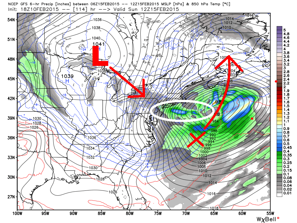
Here’s the latest GFS showing the clipper arriving over the Great Lakes, transferring to the red X over New Jersey and then bombing out as it tracks N/NE into SE Canada. While light snow would be likely during the initial transfer, the bigger thing to watch is that inverted trough (circled in white). That would create a heavier swath of snow through New Jersey as it pulls away with crazy snow ratios. Again, this would be like capturing lightning in a bottle but it’s one way we could see more snow out of this system. The more probable scenario would be just light snow from the clipper and a late phase.
So what are we supposed to make of all of this for the upcoming two snowfall potentials? Well for one thing, the Thursday-Friday event looks lighter than the Saturday night-Sunday event simply because it’s more progressive and weaker. The clipper-transfer should at least drop light snowfall across New Jersey but I wouldn’t get that excited about it. Wear your pajamas inside out Thursday night! I’m much more interested in the Saturday night-Sunday potential because there’s a decent amount of blocking and a stronger system. We’re talking about a low that bombs out into possibly the 950s (mb) before hooking into Nova Scotia/Newfoundland. This should be a rapidly deepening (bombogenesis) occurrence but again, will it happen in time to get New Jersey in on the big snow or will skip and move on to dump more heavy snowfall on coastal New England?
So with both events, I’ll be monitoring model guidance heading into the event but more importantly I’ll be watching the live dynamics at 700mb and 500mb in the ultra-short range (6-12 hours before storm and as it starts). This will be the only concrete determination as to whether minor or significant+ accumulations fall on New Jersey. Unfortunately models are struggling this year so it’s time to get down on some hard-core old-school meteorology with live observation/pattern analysis. As far as anticipating/planning/etc. I recommend preparing for the full spread of possibilities just in case we do get the perfect phase. I’d say there is an 80% chance of these systems phasing late and only producing minor impact throughout New Jersey. That leaves a 20% chance of over-performance. Also please remember that these two systems will be dancing around the coldest air we’ve seen this winter. That’s the best I can do for now.
In English: Two snowfall possibilities exist in the next 6 days. First is Thursday-Friday and then Saturday night-Sunday. Both systems have high bust potential given how many dynamics have to align perfectly for big snow. 80% of the time these systems disappoint but it’s best to be ready just in case that 20% happens. Again, very cold conditions are expected starting this Friday and lasting well into next week so have a plan to stay warm. Be safe! JC
Model images used with permission from WeatherBell Analytics.

Jonathan Carr (JC) is the founder and sole operator of Weather NJ, New Jersey’s largest independent weather reporting agency. Since 2010, Jonathan has provided weather safety discussion and forecasting services for New Jersey and surrounding areas through the web and social media. Originally branded as Severe NJ Weather (before 2014), Weather NJ is proud to bring you accurate and responsible forecast discussion ahead of high-stakes weather scenarios that impact this great garden state of ours. All Weather. All New Jersey.™ Be safe! JC


LOCAL FORECAST | INTERACTIVE RADAR | LATEST NJ WEATHER ALERTS | WEDDING FORECAST| PRIVACY POLICY
© Copyright 2026 Weather NJ LLC. All Rights Reserved.
Some information that can be found on our website is provided by a private weather station and is not an officially recognized station for weather reporting. Though we always strive to achieve accurate reporting for our own use, it is important that you do NOT depend on the data provided here for any purpose.
