

Feb 10: Winter Storm Approaching
Discussion: Most model guidance, that specializes in short-range solutions, like the RGEM/NAM/etc. have suggested a slightly more amplified shortwave and a little less suppression influence from the polar vortex energy just to our N.
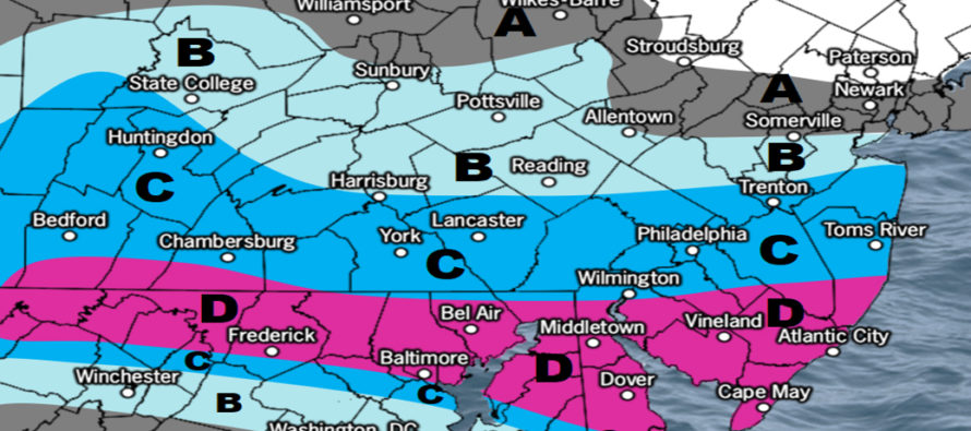
This means that the precipitation shield from this system will target closer to the Mason Dixon line (PA/MD border) extended into SNJ. This brings more of SNJ and even CNJ into the game with plowable accumulations. It keeps the Atlantic City-Cape May latitudes in the jackpot zone however. So no one is being robbed of snowfall here, just more for people further N in NJ.
Even though this is a prolonged series of two precipitation batches, it appears that the first batch will deliver most snow between tonight and noon tomorrow. The second wave has trended S and might not even scrape extreme SNJ. But this first part of is going to snow pretty good across CNJ/SNJ with SNJ favored for the highest accumulation totals.
This should be a colder snow and therefore more of a traditional drier feel, not the heavy wet stuff like this past Sunday. Snow ratios might even exceed 12:1 for CNJ and NSNJ. The surface could be close to marginal for extreme SNJ however it is plenty cold aloft even as low as 925mb. So there is some sleet showing up for the Cape May area in the middle of the snowfall. It’s possible that a warm nose could move through. However there should be enough snow around and outside of any sleet periods to still achieve our expectations on the snow map:
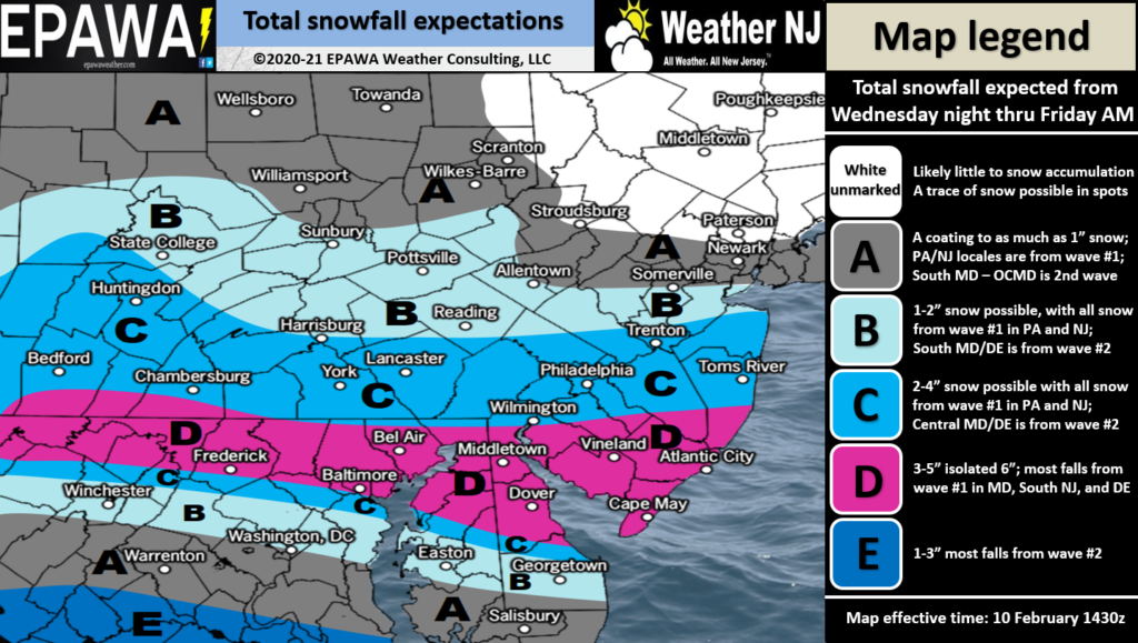
There is wildcard potential here, especially for SNJ. Just as SNJ/SENJ tends to miss warm on traditional snow/rain line solutions, the same areas tend to bust high with colder South Jersey Express waves like these. Our map allows for 6 in some spots but I wouldn’t be surprised to see some areas with even more than that. But for much of SNJ, this should feel very supplemental to recent snows in NNJ/CNJ.
In English: It might snow for all of NJ tonight through about noon tomorrow. NNJ would be subject to the lowest accumulations. CNJ could get in on plowable accumulations. SNJ is the jackpot with at least a significant plowable event expected. Our map above reflects such. Snow should approach this evening and therefore just live observations and forecast impact updates from here. Have a great night and please be safe! JC
Jonathan Carr (JC) is the founder and sole operator of Weather NJ, New Jersey’s largest independent weather reporting agency. Since 2010, Jonathan has provided weather safety discussion and forecasting services for New Jersey and surrounding areas through the web and social media. Originally branded as Severe NJ Weather (before 2014), Weather NJ is proud to bring you accurate and responsible forecast discussion ahead of high-stakes weather scenarios that impact this great garden state of ours. All Weather. All New Jersey.™ Be safe! JC


LOCAL FORECAST | INTERACTIVE RADAR | LATEST NJ WEATHER ALERTS | WEDDING FORECAST| PRIVACY POLICY
© Copyright 2026 Weather NJ LLC. All Rights Reserved.
Some information that can be found on our website is provided by a private weather station and is not an officially recognized station for weather reporting. Though we always strive to achieve accurate reporting for our own use, it is important that you do NOT depend on the data provided here for any purpose.
