

Feb 11: Another Northeast US Storm
Low pressure will be moving through New Jersey tomorrow (Sunday). It is expected to stay above 1000mb before ejecting into the Atlantic Ocean later tomorrow evening and bombing out for New England on Monday—less than a week after the recent high-impact storm that battered such areas.
For New Jersey, this likely means a small wintry precipitation threat tomorrow morning for NNJ (likely N of I-80 and especially for the higher NWNJ elevations). Just to paint the general idea, here’s the latest 12Z NAM showing precipitation types and intensity just before noon tomorrow:
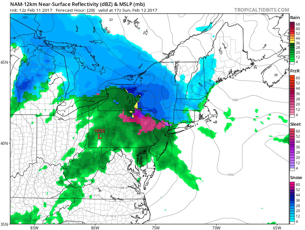
It’s a hard call on when the freezing rain threat would subside for NNJ, especially NWNJ. Precipitation might end before the surface becomes warm enough to mitigate the freezing rain concern. Right along I-80, especially NENJ, might eventually get there (become warm enough at the surface) but the higher NWNJ elevations should just play it safe and expect the possibility through afternoon-evening hours. For everyone S of I-80 in New Jersey, you should expect mostly rain tomorrow. Here are the total expected precipitation amounts through Monday:
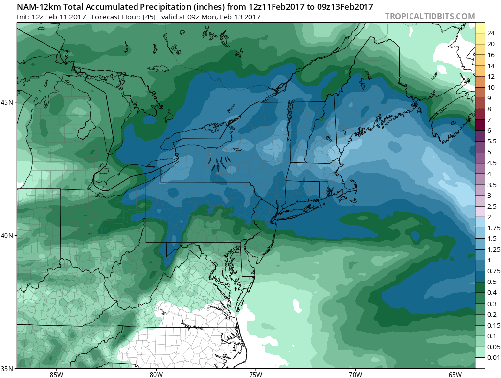
It looks like about .75 inches of total rain N of I-78 and lesser tapering amounts from I-78 down through extreme SNJ. Let’s allow up to 1 inch locally in NNJ just in case. the general idea is more in NNJ than SNJ.
Once the low gets over the Atlantic tomorrow evening into Monday, it will intensify from 1000mb down to a sub-980mb (possibly sub-970mb) storm for the Gulf of Maine. Our flow will switch and we’re likely going to feel the backside of that wind field in the form of gusty NW winds. I’m not enthused on back-side snow. Perhaps some lake-effect action could enhance a few remnant areas of precipitation but that shouldn’t produce anything more than scattered snow showers with little-to-no accumulation. NWNJ would be favored over SENJ for such.
In English: Tomorrow should be rainy for CNJ and SNJ. NNJ (especially NWNJ) is subject to a brief initial period of snow followed by a longer period of freezing rain through most of tomorrow morning. The threat will start for all of NNJ but should subside to NWNJ-only before precipitation tapers off. Please be careful up there! The rest of NJ should expect rain tomorrow and then all areas should expect gusty NW winds tomorrow night into Monday. I’m still watching the Wed-Thurs period for another potential winter storm. The pattern still looks good at the upper-levels but the surface has yet to consensually lock on to a solution. Let’s take another look tomorrow with the Monday-Friday Outlook. Everyone have a great Saturday and please be safe! JC
Jonathan Carr (JC) is the founder and sole operator of Weather NJ, New Jersey’s largest independent weather reporting agency. Since 2010, Jonathan has provided weather safety discussion and forecasting services for New Jersey and surrounding areas through the web and social media. Originally branded as Severe NJ Weather (before 2014), Weather NJ is proud to bring you accurate and responsible forecast discussion ahead of high-stakes weather scenarios that impact this great garden state of ours. All Weather. All New Jersey.™ Be safe! JC


LOCAL FORECAST | INTERACTIVE RADAR | LATEST NJ WEATHER ALERTS | WEDDING FORECAST| PRIVACY POLICY
© Copyright 2026 Weather NJ LLC. All Rights Reserved.
Some information that can be found on our website is provided by a private weather station and is not an officially recognized station for weather reporting. Though we always strive to achieve accurate reporting for our own use, it is important that you do NOT depend on the data provided here for any purpose.
