

Feb 11: More Wintry Precipitation Approaching
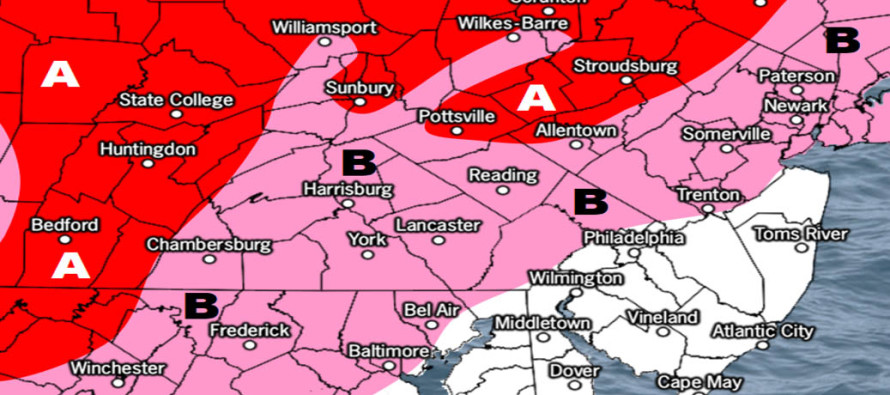

Click here to view full resolution map!
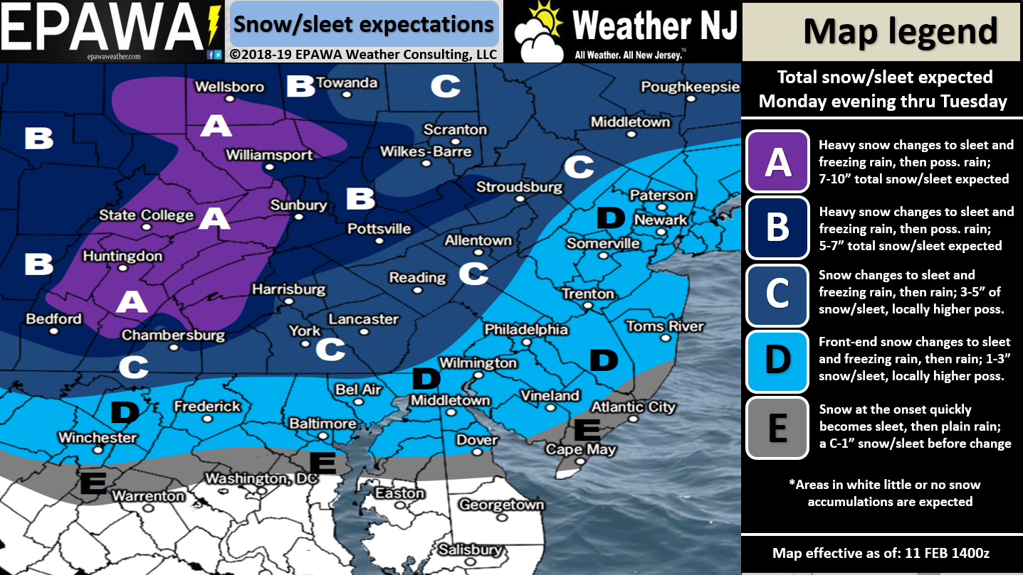
Click here to view full resolution map!
Discussion: This article and its snow maps are being advertised as “from this point forward” meaning they do not include any snow or ice that has fallen so far. The first system has wrapped up and many locations across SNJ reached into the 2-4″ category with a few reports of 4-5″ near Vineland and and some other localized areas. It’s now time for the second system which carries a far-worse safety risk IMO because we are dealing with ice.
So starting this afternoon, precipitation will build across SNJ and work its way northward into CNJ and NNJ. Precip should start as a mix or all plain rain for extreme SNJ. Draw a line from Wilmington, DE over to about Atlantic City, NJ. From that line and S expect little to no wintry accumulation both tonight and tomorrow morning. Extreme SNJ is likely too warm for the rest of this system. From that line and northward however expect a front-end burst of snow to eventually change to sleet, freezing rain and then lastly plain rain. SNJ should changeover the quickest, CNJ second and lastly NENJ. NWNJ has the best chance to remain wintry (likely as ice not snow). Most precip this afternoon through midnight tonight should be snow. The changeover is not expected to occur until the early AM hours of tomorrow (Tuesday). And here lies the most dangerous safety travel hazard.
What we’re noticing on the most-recent data is that more sleet is expected than freezing rain however both are on the table. This is due to a shallower layer of warm air intruding the low-mid levels (while the lower levels remain cold…initially). I-95/NJTP and points SE should go over to rain fairly quickly tomorrow morning. Areas NW of I-95/NJTP and especially N of I-80/NW of I-287 are subject to the most amount of ice either in the form of sleet or freezing rain. Again ice is far more dangerous than snow regarding travel. I’m not going to sugar coat it. Tomorrow’s AM commute NW of I-95/NJTP is going to be a word that rhymes with fit show. And conditions might persist for said areas well into the afternoon before fully changing over. It is my recommendation not to travel in these areas tomorrow morning if you can avoid it. NOT because of the initial snow but BECAUSE OF ICE. Areas like Sussex County could actually stay all ice tomorrow by the time precipitation tapers off just before or after midnight.
In English: More snow is approaching from the W. It will start in northern SNJ today and creep northward tonight. Our above snow map shows how much snow should between now and just after midnight tonight (before the changeover). Snow should change to sleet and/or freezing rain between 4am and noon tomorrow for most of NJ (NNJ elevations possibly slightly later). Ice should then change to rain from SNJ to NNJ between noon tomorrow and midnight tomorrow night. NNJ elevations might never change to rain before precipitation ends by early Wednesday morning. Please don’t try to be the hero tomorrow morning. There’s going to be lots of school closings and cancellations N of I-195 for a reason. Ice is nothing to joke around about. For those curious/asking there are several winter storm signals over the next few weeks. The first one being later this weekend. Download the new free Weather NJ mobile app on Apple and/or Android. It’s the easiest way to never miss Weather NJ content. Have a great rest of your Monday and please be safe! JC
Jonathan Carr (JC) is the founder and sole operator of Weather NJ, New Jersey’s largest independent weather reporting agency. Since 2010, Jonathan has provided weather safety discussion and forecasting services for New Jersey and surrounding areas through the web and social media. Originally branded as Severe NJ Weather (before 2014), Weather NJ is proud to bring you accurate and responsible forecast discussion ahead of high-stakes weather scenarios that impact this great garden state of ours. All Weather. All New Jersey.™ Be safe! JC


LOCAL FORECAST | INTERACTIVE RADAR | LATEST NJ WEATHER ALERTS | WEDDING FORECAST| PRIVACY POLICY
© Copyright 2026 Weather NJ LLC. All Rights Reserved.
Some information that can be found on our website is provided by a private weather station and is not an officially recognized station for weather reporting. Though we always strive to achieve accurate reporting for our own use, it is important that you do NOT depend on the data provided here for any purpose.
