

Feb 12: Ice Storm Approaching
Discussion: A very strung-out wave of energy, focused on a weak and unorganized area of low pressure, will impact NJ with precipitation between Saturday morning and noon on Sunday. The weak low will eject into the Atlantic Ocean near OBX and track just offshore of NJ before moving away to the E. The temperature profile during this precipitation is pretty wild through NJ with the boundary nearby.
The Titans clash. The Arctic air to our N powered by the polar vortex energy lobe in the N/C US is strongly pushing against a strong ridge partly over the SE US. The boundary (battlefield) separates the air masses and is right near us here in NJ. Since heat rises and cold falls, the Arctic air will slide to the SE over NJ at the surface while the warmth and moisture slide NW over NJ at the low-mid layers (925-850mb). Temps then drop just above that warm layer by the time you approach 700mb and especially 500mb. This creates a line of freezing that widely varies with altitude. For this Saturday-Sunday ice storm, there’s a point where some of SENJ could be below freezing at the surface while NWNJ is above freezing at the low-mid layers.
So we’re going to have a heck of a warm nose in the mid-layers ruining what could have been snow. The layer will be shallower NW of 95 and therefore more sleet will be allowed to mix in with the freezing rain. But for most along and SE of 95, the primary threat will be freezing rain which hits the ground as a wet rain drop and freezes/accrues as ice. NWNJ elevations have the best chance to see mostly sleet and some amounts of snow mixed in. Therefore maybe Sussex County could see a general C-2 inches of frozen accumulation.
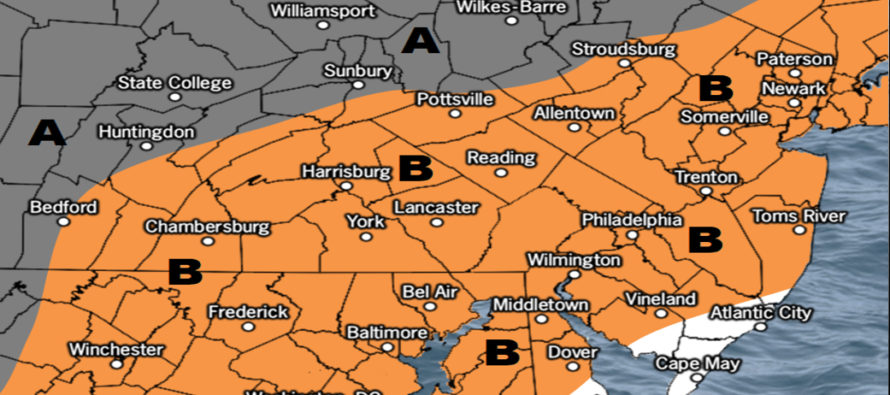
I expect a portion of SENJ/ECNJ to rise above freezing during this event. That area is illustrated on the below map. This extreme SENJ area could initially start as a wintry mix but should lose the ice accrual threat once above 32. SNJ and CNJ should use the surface temp line of freezing as an indicator for ice accrual. The following maps represent snow and sleet (top) and freezing rain (bottom) potential:
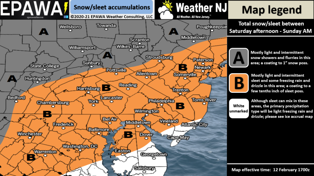
Full Resolution Snow/Sleet Map
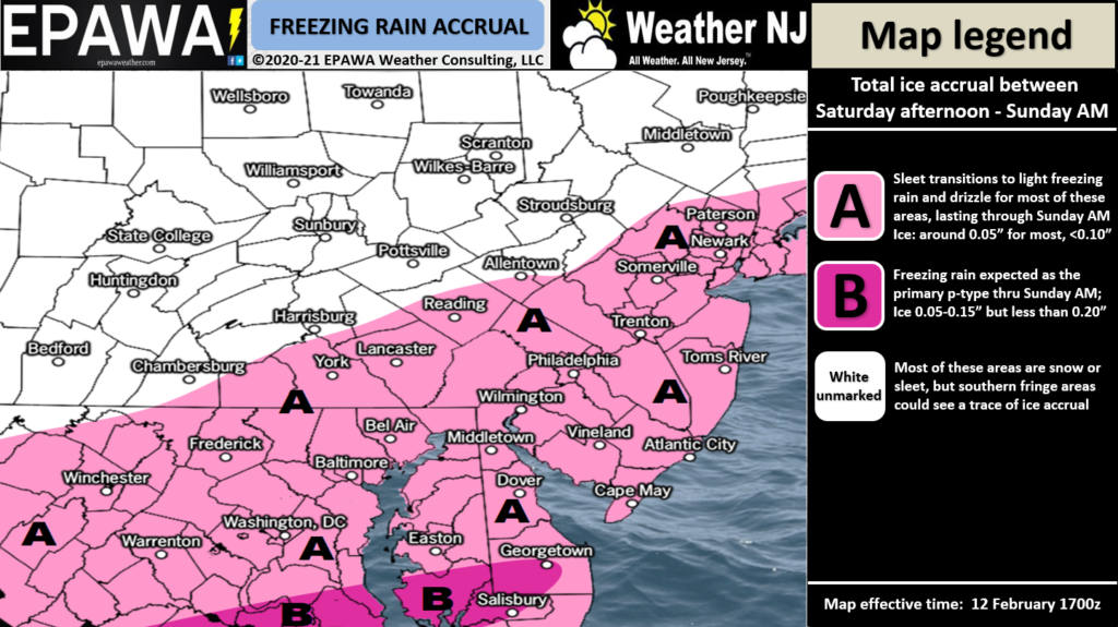
Full Resolution Freezing Rain Map
A few days later looks like another possible ice storm on Tuesday (Feb 16) with a similar temperature profile but a higher intensity of precipitation. The next signal after that (Feb 18-20) is looking like an ice-to-rain situation as well. Not seeing any significant snow for NJ in the near-future but I’m smart enough not to toss the towel until mid-to-late March.
In English: An ice storm is likely this Saturday morning through about noon on Sunday. This means mostly a mix of sleet and freezing rain for most of the state. SENJ locations could rise above freezing at the surface for some of the event—eliminating the ice accrual. The rest of NJ, however, is expected to be below freezing at the surface while either sleet or freezing rain falls from aloft. We’ll be very cold leading up to this (tonight into tomorrow morning) and again, will only rise above freezing for SENJ during the event. It’s not a lot of ice but it doesn’t take much to create serious travel safety concerns. For this event roads will need treatment (salt/whatever works in cold temps) not plowing. It looks like a light-to-moderate batch of precipitation from Saturday morning through Saturday night, then a lull of lighter precipitation overnight, and lastly a finishing light-to-moderate batch that ends by noon on Sunday. All precipitation will be dangerous if it hits a surface that’s 32F or less. And again, that’s most of NJ less SENJ. We’ll likely deal with a similar storm on Tuesday. I’ll take a deeper dive on that tomorrow. Have a great rest of your Friday and please be safe! JC
Jonathan Carr (JC) is the founder and sole operator of Weather NJ, New Jersey’s largest independent weather reporting agency. Since 2010, Jonathan has provided weather safety discussion and forecasting services for New Jersey and surrounding areas through the web and social media. Originally branded as Severe NJ Weather (before 2014), Weather NJ is proud to bring you accurate and responsible forecast discussion ahead of high-stakes weather scenarios that impact this great garden state of ours. All Weather. All New Jersey.™ Be safe! JC


LOCAL FORECAST | INTERACTIVE RADAR | LATEST NJ WEATHER ALERTS | WEDDING FORECAST| PRIVACY POLICY
© Copyright 2026 Weather NJ LLC. All Rights Reserved.
Some information that can be found on our website is provided by a private weather station and is not an officially recognized station for weather reporting. Though we always strive to achieve accurate reporting for our own use, it is important that you do NOT depend on the data provided here for any purpose.
