

Feb 12: Initial Weekend Snow Map & Discussion
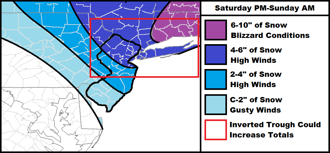
The Arctic outbreak of cold air is the main story which begins tonight, peaks between Sunday-Monday and lasts well into next week. As far as snow potential goes, it’s now time to focus on the Saturday-Sunday period. Another clipper will be transferring to the Atlantic Ocean, much more robust than today, and likely bringing another blizzard to coastal New England. Our potential snow scenarios vary from just widespread snow showers/light accumulations to a more significant event and here’s why…
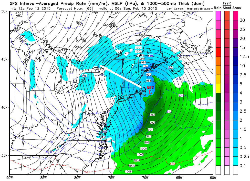
An inverted trough is likely to set up on the west side of the coastal low (once it bombs out). This should extend a band of high-ratio heavy snowfall westward from the center of the low that’s currently modeled between coastal New Jersey and Albany (from south to north). Someone is going to get this band of snow but it’s simply too hard to predict the exact location at this point. What’s making it even more difficult to forecast is the fact that the inverted trough “could” starve surrounding areas of snowfall as air rises over the inverted trough and falls next to it. Rising air = area of snowfall and sinking air = dry moisture starvation. As I’ve mentioned in the past, this is the same feature that robbed New Jersey of it’s snowfall a few weeks ago when the inverted trough set up over central PA. I also want to emphasize that strong northerly winds will accompany this system, especially once the low intensifies over the ocean.
So let’s consider the following guidance. I’ve drawn the central axis of the inverted trough (indicated by the white line). This represents where the heaviest snowfall would occur in relation to that model’s output:
GFS:
Canadian:
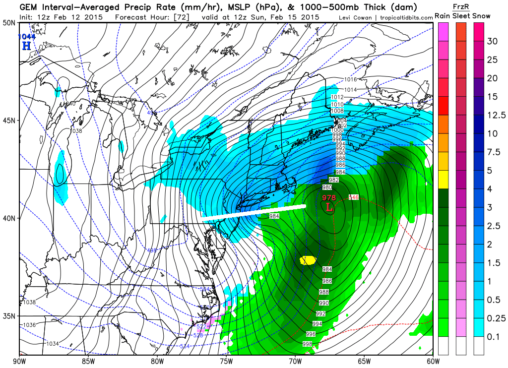
The Euro is very similar to the Canadian with the heavier snow falling through NYC and surrounding NJ areas. Again, where this feature sets up will have tremendous impact on final accumulation amounts. Otherwise, expect very high ratio snowfall due to colder air at the mid and upper levels. This means that instead of 10:1 snow ratios (10 inches of snow for every inch of liquid) NJ could see up to ~25:1 snow ratios (25 inches of snow for every inch of liquid). So if two tenths of an inch of liquid falls, it would equate to 4-5 inches of snow instead of the 2 inches of snow that would fall from a marginal coastal situation. If snow ratios were not a major factor then you would be able to cut these expected totals in half…but it will be a factor.
In English: The snow map is pretty straight-forward for Saturday afternoon through Sunday morning. Strong winds should set up out of the N/NW once the low is to our east so downed power lines and trees could be a concern. I’ll be able to identify the location of the inverted trough during now-casting. Otherwise, this map represents my current thoughts. I’ll have time for two more updates before the storm starts to account for any trends that occur (tomorrow evening and Saturday just before storm starts). Be safe! JC
Jonathan Carr (JC) is the founder and sole operator of Weather NJ, New Jersey’s largest independent weather reporting agency. Since 2010, Jonathan has provided weather safety discussion and forecasting services for New Jersey and surrounding areas through the web and social media. Originally branded as Severe NJ Weather (before 2014), Weather NJ is proud to bring you accurate and responsible forecast discussion ahead of high-stakes weather scenarios that impact this great garden state of ours. All Weather. All New Jersey.™ Be safe! JC


LOCAL FORECAST | INTERACTIVE RADAR | LATEST NJ WEATHER ALERTS | WEDDING FORECAST| PRIVACY POLICY
© Copyright 2026 Weather NJ LLC. All Rights Reserved.
Some information that can be found on our website is provided by a private weather station and is not an officially recognized station for weather reporting. Though we always strive to achieve accurate reporting for our own use, it is important that you do NOT depend on the data provided here for any purpose.
