

Feb 14: Another Ice Storm Approaching

Discussion: Another ice storm is approaching and this one looks more potent. Where the recent one hit mostly 95 and SE, this one is targeting 95 and NW. There’s not much to say. The atmosphere is warm over New Jersey at the low-mid levels and cold at the surface, especially with the existing region-wide snowpack.
This storm should begin dropping light precipitation overnight tonight/early Monday morning. Precipitation should be on-and-off light through Monday afternoon before picking up into Monday evening. It looks like precip ends early Tuesday AM from W to E.
The storm should start colder and end warmer. I think we’ll see a snow/sleet line establish and quickly push NW out of NWNJ. Then the sleet/rain line should start near I-95 and push further NW into WCNJ/NENJ. With that said, the lower 2/3 of NJ should see rain falling on above-freezing ground by Monday night. Areas where it’s still below freezing at the surface will only be the concerning locations for icing (N of I-80/NW of I-287) heading into early Tuesday morning. Cold air damming could occur, especially against the NWNJ Appalachian Mountains and with that snow pack. So the wildcard is a colder solution overall but still not SE of I-95. Here’s our ice impact map for Monday morning into Tuesday morning:
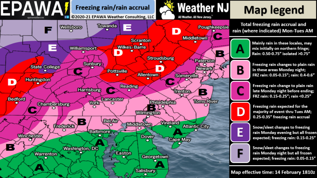
Zone A is likely all rain for the entire event (Monday AM-Tuesday AM) and too warm for wintry concern. Zones B and C see all their ice Monday morning through Monday afternoon before changing to plain rain through Tuesday AM. Zone D sees light snow change to light ice Monday morning into Monday afternoon then sees heavier icing Monday PM into Tuesday AM.
In English: Another ice storm is coming primarily in the form of rain that falls and freezes after impact. Sleet (falls and hits ground as an ice pellet) is also possible but not as probable as the freezing rain threat. This one should hit NWNJ/WCNJ/NENJ pretty hard. Sort of supplemental to the one that just hit SWNJ/SENJ/ECNJ. Most of NJ SE of 95 should escape the worst of this one. This storm seems stronger though meaning more ice accrual, especially for NWNJ. Branches will be heavy and falling, likely causing outages. Untreated roads and walkways will be horrible to travel on. I’ll cover more on the Feb 18-19 storm signal tomorrow. Please be safe!
Jonathan Carr (JC) is the founder and sole operator of Weather NJ, New Jersey’s largest independent weather reporting agency. Since 2010, Jonathan has provided weather safety discussion and forecasting services for New Jersey and surrounding areas through the web and social media. Originally branded as Severe NJ Weather (before 2014), Weather NJ is proud to bring you accurate and responsible forecast discussion ahead of high-stakes weather scenarios that impact this great garden state of ours. All Weather. All New Jersey.™ Be safe! JC


LOCAL FORECAST | INTERACTIVE RADAR | LATEST NJ WEATHER ALERTS | WEDDING FORECAST| PRIVACY POLICY
© Copyright 2025 Weather NJ LLC. All Rights Reserved.
Some information that can be found on our website is provided by a private weather station and is not an officially recognized station for weather reporting. Though we always strive to achieve accurate reporting for our own use, it is important that you do NOT depend on the data provided here for any purpose.
