

Feb 15: First Call Weekend Snow Map
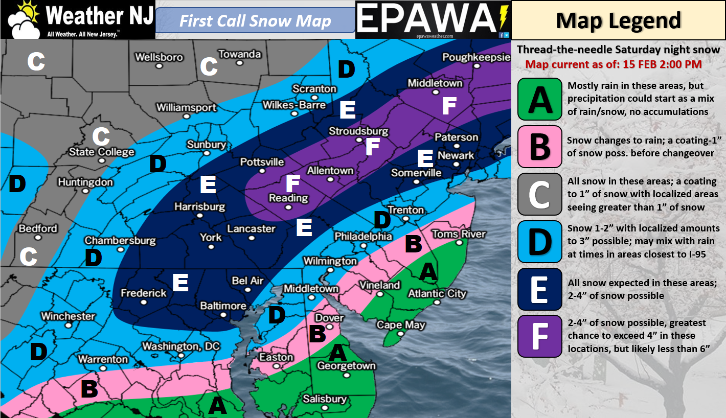
Click here for full-resolution impact map!
Discussion: Not much has changed since last night’s article. We have a weak coastal low tracking close to SENJ. That’s going to put zone A and B in the most probable zone for a snow/rain mix or even just cold rain only, especially along coastal areas. Onshore flow from the low will be the culprit for this over 37-39F degree ocean surface temperatures. With that said, points SE of I-95 should expect little-to-no accumulation as you move from I-95 towards the SENJ coast.
Points along I-95 (zone D) are likely to see light accumulations and points NW of I-95 are likely to see light-to-significant accumulations. I have no doubt that we could see a period or two of heavy snowfall in the jackpot zone (zones E and F). What’s preventing this system from being a bigger snowfall accumulation is duration. We’re looking at 6-8 hours of precipitation. That coupled with the warmer boundary layer means that 6-8 inches is probably the biggest jackpot this system could dump if reaching maximum potential (for those in NJ along and NW of I-95).
The rain zone (SE of I-95), which is also the jackpot zone from the Jan 3-4 blizzard earlier this year, will be too warm. NOT BECAUSE IT WAS 60+ TODAY/TOMORROW. A cold front will drop all surface temperatures below freezing by Saturday morning so that’s out of play. The reason for the warmer boundary level that could creep back to the I-95 corridor is from onshore flow ahead and to the N of the weak coastal low. There is no high pressure to our N to force the lower-levels colder. It’s as simple as that.
Timing looks like early-to-mid Saturday evening to early Sunday AM hours. Therefore sun angle should not be a problem. As I said last night, this could be a plowable, possibly significant snowfall, but likely not a major snow event. It’s a thread the needle scenario nested between two milder periods of weather.
In English: Expect another mild day tomorrow to start. Temps will then crash tomorrow evening and fall well-below freezing by Saturday morning. All of NJ is expected to see precipitation between Saturday evening and early Sunday morning. Precipitation should be wintry along and NW of I-95 and non-wintry SE of I-95. We could all end as snow but with not much time left given how short-duration this event should be. Our map above indicates our first call. Our final call will be tomorrow with any necessary adjustments made. Have a great night and be safe! JC
For comprehensive and interactive hyper-local analysis that goes way above and beyond the detail of this public forecast, check out our premium services which include text notifications and forum access.
Jonathan Carr (JC) is the founder and sole operator of Weather NJ, New Jersey’s largest independent weather reporting agency. Since 2010, Jonathan has provided weather safety discussion and forecasting services for New Jersey and surrounding areas through the web and social media. Originally branded as Severe NJ Weather (before 2014), Weather NJ is proud to bring you accurate and responsible forecast discussion ahead of high-stakes weather scenarios that impact this great garden state of ours. All Weather. All New Jersey.™ Be safe! JC


LOCAL FORECAST | INTERACTIVE RADAR | LATEST NJ WEATHER ALERTS | WEDDING FORECAST| PRIVACY POLICY
© Copyright 2026 Weather NJ LLC. All Rights Reserved.
Some information that can be found on our website is provided by a private weather station and is not an officially recognized station for weather reporting. Though we always strive to achieve accurate reporting for our own use, it is important that you do NOT depend on the data provided here for any purpose.
