

Feb 15: Late Afternoon Observations
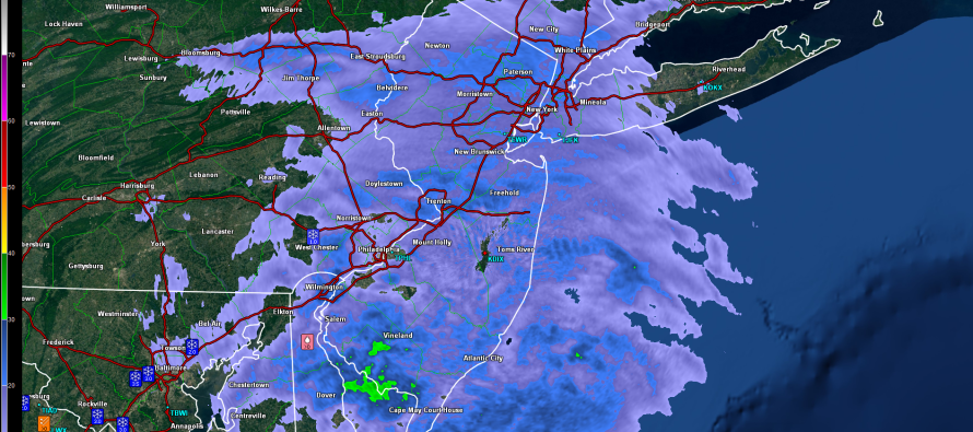
Precipitation continues to spread northward through New Jersey. The high pressure in the ocean has provided E/SE flow which has taken surface temps for coastal NJ and SENJ above freezing. The 850mb southerly jet is taking shape from the developing low to our SW as well. With that said, the snow should now change over to rain faster than the surface warms underneath it from N to S. Hence the ice storm setting up.
First we have to get through remaining snowfall accumulations for areas along and NW of the turnpike. I’d say a few more hours of snowfall are possible before the changeover so an additional 1-3 on top of what you have now if you are still snowing. CNJ and NENJ should changeover to rain first heading into the early evening hours. The elevations of NWNJ should go last…later in the evening/overnight hours.
The ice storm potential is beginning to materialize. It should first show it’s ugly head in SWNJ sooner than later. Some sleet and mostly freezing rain should then spread across Eastern PA and W/NWNJ (NW of 95/NJTP). SENJ and most of the coast are basically finished with snowfall and should expect mostly rain from hereon out.

In English: No real surprises to the forecast. SENJ is now rain. SWNJ, CNJ and NENJ will transition to rain soon but should still snow up to a few hours more. NWNJ will transition to rain last with snowfall possible for another 3-5 hours. An ice storm is then expected during the transition to rain with up to .25″ ice accumulations possible from now through overnight hours. This will make be highly disruptive for travel and will weigh down power lines so please be careful. Rainfall for most of the state should then persist through tomorrow morning. I would give it until early afternoon tomorrow for everything to taper off. My next observational article will be out later this evening. Be safe! JC
Jonathan Carr (JC) is the founder and sole operator of Weather NJ, New Jersey’s largest independent weather reporting agency. Since 2010, Jonathan has provided weather safety discussion and forecasting services for New Jersey and surrounding areas through the web and social media. Originally branded as Severe NJ Weather (before 2014), Weather NJ is proud to bring you accurate and responsible forecast discussion ahead of high-stakes weather scenarios that impact this great garden state of ours. All Weather. All New Jersey.™ Be safe! JC


LOCAL FORECAST | INTERACTIVE RADAR | LATEST NJ WEATHER ALERTS | WEDDING FORECAST| PRIVACY POLICY
© Copyright 2026 Weather NJ LLC. All Rights Reserved.
Some information that can be found on our website is provided by a private weather station and is not an officially recognized station for weather reporting. Though we always strive to achieve accurate reporting for our own use, it is important that you do NOT depend on the data provided here for any purpose.
