

Feb 15: Wintry Weather Update
Discussion: Precipitation so far today has been very isolated and drizzly with most areas still dry as of now. Ultra-short-range model guidance and live obs indicate similar conditions holding until about 11PM tonight. From 11PM into Tuesday morning, precipitation should break out and intensify—ultimately tapering off by late Tuesday morning. The low is tracking a little more NW of yesterday’s data with a drier overrunning precipitation shield WHICH IS GOOD for NJ re: ice.
The surface is only below freezing along and N of I-80/NW of I-287…maybe some parts of N Bergen/Passaic Counties in NENJ. The 850mb layer (about 5k feet up) is above freezing for all expect extreme NWNJ. I expect the warming at lower levels to continue pushing N placing most of NJ above freezing at the surface and 850mb by daybreak Tuesday morning. This means that the only NJ wintry hazard left is for NWNJ overnight tonight between about 11pm and 5am.
On the ice map we released yesterday, basically zones A and B have been in the clear today and will continue to be through tomorrow morning. Zones C and D still have the main batch of sleet/freezing rain to deal with tonight into early tomorrow morning. Trust me on this, the less ice the better so I am happy to see that today has already been “not as bad as it could have been.” Hopefully that’s the case tonight for NWNJ but the guidance and obs say it’s coming. We’ll taper off by late-morning tomorrow (Tuesday) and then temps fall colder again Tuesday night through Thursday.
There are two remaining wintry storm signals I’m tracking to likely end the stretch of the active wintry pattern. The first is this Thursday-Friday (Feb 18-19) and the second is this Sunday-Tuesday (Feb 21-23). I won’t even touch the second one until we’re wrapping up the first. After these two signals I’m not seeing anything for the rest of February. It’s too soon to tell for March. We all know March can go both ways (back-loaded winter or early spring). With that said, let’s discuss what could happen as soon as this Thursday.
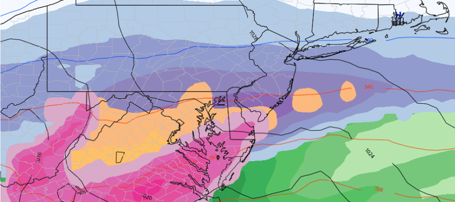
Like I said, the current ice event low (tonight through tomorrow morning) will rip down cold behind it to establish a colder Tuesday night through all of Wednesday and into Thursday for NJ. A low is then expected to track just offshore of NJ on Friday. But before the low approaches the coast, the overrunning precipitation shield could thump snow on Thursday before the lower level warming pushes in early Friday morning. This is ultimately a snow to ice to rain event. But it currently looks like there will be more snow/ice up front before ending as rain. A lot of models are putting down at least 3-6 ahead of the changeover and very little rain to finish. We’ll likely only spend a small amount of time in the warm sector nose late Thursday night into Friday. The above cover image is from the GFS showing the front-end snow thump on Thursday. I’ll be watching this signal close and will provide more details tomorrow.
In English: Ice should only be a concern later tonight for NWNJ (N of I-80/NW of I-287). And the concern is slippery roads/walkways that are untreated and power outages related to heavy ice-accrued tree branches falling. The rest of NJ has been above freezing or is currently warming above freezing. Today’s lighter precip has mostly held off aside from some passing mist/drizzle. That’s still producing some NWNJ problems right now. The main precipitation type expected tonight is rain. There might be some sleet for extreme NWNJ but mostly rain. If it’s at or below 32 on your surface then it will freeze after impact. If it’s above 32 then no worries. This surface line of freezing should slowly walk N/NW overnight. The first ice storm a few days ago hit SENJ. This one will end up hitting NWNJ. Much of the area between (along 95 and 30 miles or so in either direction) has been spared from both which is a good thing being the most heavily traveled area of NJ. We now look to more snow on Thursday for most of the state before changing to rain by Friday. Have a great rest of your President’s Day and please be safe! JC
Jonathan Carr (JC) is the founder and sole operator of Weather NJ, New Jersey’s largest independent weather reporting agency. Since 2010, Jonathan has provided weather safety discussion and forecasting services for New Jersey and surrounding areas through the web and social media. Originally branded as Severe NJ Weather (before 2014), Weather NJ is proud to bring you accurate and responsible forecast discussion ahead of high-stakes weather scenarios that impact this great garden state of ours. All Weather. All New Jersey.™ Be safe! JC


LOCAL FORECAST | INTERACTIVE RADAR | LATEST NJ WEATHER ALERTS | WEDDING FORECAST| PRIVACY POLICY
© Copyright 2025 Weather NJ LLC. All Rights Reserved.
Some information that can be found on our website is provided by a private weather station and is not an officially recognized station for weather reporting. Though we always strive to achieve accurate reporting for our own use, it is important that you do NOT depend on the data provided here for any purpose.
