

Feb 16: Winter Storm Approaching
Discussion: The trend on most data over the last 24 hours has been for a colder solution Thursday-Friday. More like the solution I was thinking yesterday (what the GFS/Euro was advertising). The reason for the data changing is that the low is weaker and more of a flat wave that ejects out to sea, rather than a stronger low curving more to the N. A flatter wave means a colder scenario for most of NJ because the warmer layers to not get pulled NW as far.
However, we’re still looking at a changeover at least for SNJ, possibly CNJ. The low should track just off N OBX close to the Jersey Coast before pulling away to the E. It never really deepens below about 1004mb. But it does present SENJ/ECNJ with onshore flow that will rock counterclockwise from SE to E to NE to finish. For that reason, all wintry precipitation potential is likely on the front side thump of this system.
Snow should approach SNJ/CNJ from the W late-Wednesday night/early Thursday morning and spread into NNJ by late Thursday morning. A wintry mix of sleet and/or freezing rain should then push northward into SNJ by Thursday afternoon and ultimately peak somewhere in NNJ/CNJ. An ice/rain line will then follow from S to N possibly to I-195 by late-Thursday night/Friday morning. As the system pulls away on Friday, precipitation could go back to wintry for some but should be short-lived.
So NNJ is mostly snow to ice to snow. CNJ is snow to ice to rain to snow. SNJ is snow to ice to rain. Our following snow map indicates how much snow should accumulate before any changeover. Obviously sleet and especially rain would ultimately damage the front end snow pack.
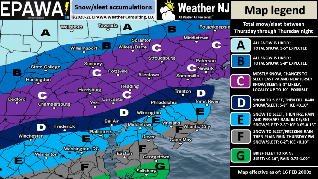
The wildcard outcome would be for zones E and F to not see much of anything wintry at all. The thermal gradient might really tighten. That would potentially mean parts of area C could KABOOM.
After this event and aside from the Feb 22-23 signal, I think we’re starting to see the light at the end of the tunnel in this wintry pattern. I imagine a few more transient cold snaps and hit-or-miss systems could happen through March. But the prolonged cold and active pattern that started Jan 31 should finally let up. Areas to our W in the C US should finally start to thaw a little.
In English: Temps should fall overnight tonight back to a wintry feel. A mix of snow, sleet, freezing rain, and plain rain should then push through NJ Thursday into Friday morning. NNJ/CNJ has the best chance to accumulate snow with the least amount of icing. Most of CNJ is likely looking at snow to ice to some rain. SNJ and especially SENJ/ECNJ will be subject to marine air that will likely change said areas over to ice or rain quicker—yielding less initial snow accumulations. Most of the wintry stuff should occur on Thursday though. Once the snow/ice and ice/rain lines push into SNJ/CNJ by Thursday evening, that’s likely it. Areas that hold onto snow the longest (NNJ) should see the highest snow accumulations from this event. Immediate coastal areas of ECNJ/SENJ will be most affected by marine air and therefore wintry accumulations should drop off closer to the coast. Our map above illustrates our evidence-based thoughts. Have a great rest of your Tuesday and please be safe! JC
Jonathan Carr (JC) is the founder and sole operator of Weather NJ, New Jersey’s largest independent weather reporting agency. Since 2010, Jonathan has provided weather safety discussion and forecasting services for New Jersey and surrounding areas through the web and social media. Originally branded as Severe NJ Weather (before 2014), Weather NJ is proud to bring you accurate and responsible forecast discussion ahead of high-stakes weather scenarios that impact this great garden state of ours. All Weather. All New Jersey.™ Be safe! JC


LOCAL FORECAST | INTERACTIVE RADAR | LATEST NJ WEATHER ALERTS | WEDDING FORECAST| PRIVACY POLICY
© Copyright 2026 Weather NJ LLC. All Rights Reserved.
Some information that can be found on our website is provided by a private weather station and is not an officially recognized station for weather reporting. Though we always strive to achieve accurate reporting for our own use, it is important that you do NOT depend on the data provided here for any purpose.
