

Feb 17: Final Call For Weekend Snow
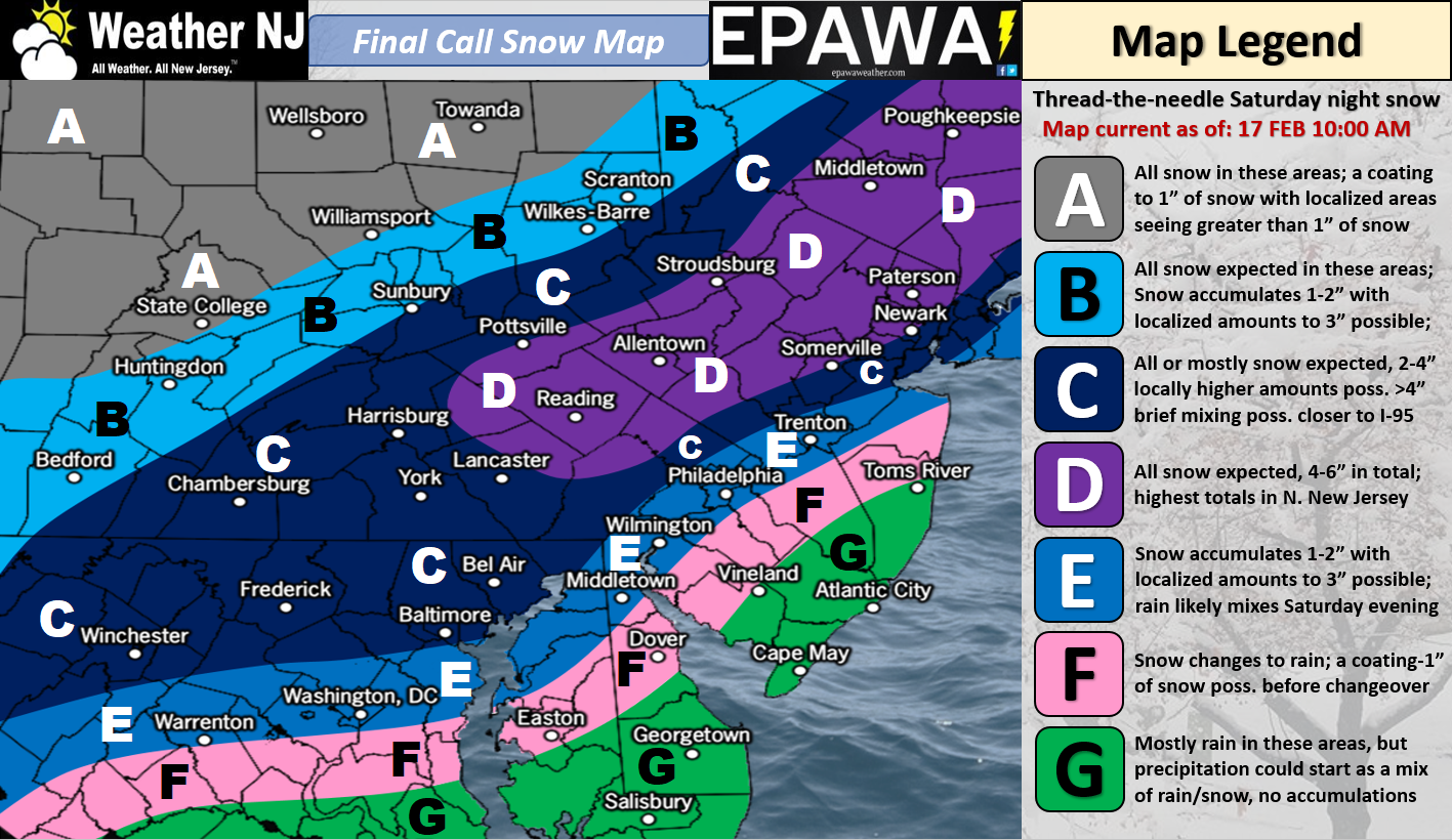
Click here to view full-resolution snow map!
Discussion: We’ve made a few tweaks based on live observations and the latest guidance data. Temperatures dropped below freezing statewide early this morning as expected. Warm air advection however has already spread into much of NJ. We can thank the departing high pressure for driving marine temperature influence onshore for this. Once the weak low approaches closer from the W/SW, the S flow will be even further re-enforced with more WAA from the S. Not only will the surface be unfavorable for stickage along and SE of I-95 but the warmer low-mid levels will likely feature warmer marine-influenced layers that should further prevent a high-impact wintry outcome. We also believe that this might force a tighter thermal gradient and enhance snowfall potential for the jackpot areas. Just keep in mind that this is a short-duration event with a marginal temperature profile.
For these reasons we believe that areas SE of I-95 (Zones F and G) will verify even warmer than we originally thought. There could still be snowfall either initially or mixed in throughout the event but zones F and G should not expect snow accumulations, especially on roads ways. The low-mid levels are expected to be simply too warm. I suppose natural surfaces could whiten up a bit but meh.
Zone E is right along the I-95 corridor. This region could see up to a few inches fall and possibly accumulate on natural surfaces. Treated roadways will likely just be wet with maybe a slushy coating on untreated roadways.
Areas along and NW of I-95 (C and D) are still favored for the snowier outcome from this event, especially parts of NJ to the N of I-78. In our first two calls, we were 2-4″ on this jackpot zone with the potential for 6″ of snow accumulation. The tweak we made here was to simply convert to a 4-6″ expectation. We feel that a minimum of 4 inches is more reasonable than 2 inches. The top bound of 6″ is still the same for the jackpot area which we’ve shifted a tad further to the SE.
Timing still looks like early evening today (Saturday) through early AM hours tomorrow (Sunday) morning. Precipitation arrives from the W and departs to the E. Therefore W parts of NJ could see precipitation begin as early as late-afternoon today and E parts of NJ will be the last to wrap up tomorrow morning.
In English: A light-to-significant snowfall is expected along and NW of I-95. A cold rain with snow possibly mixing in is possible to the SE of I-95. Extreme SENJ has the best chance to see all cold rain. Precipitation should break-out between late-afternoon and early-evening and wrap up by sunrise tomorrow morning. The above impact map represents our final call heading into live observations. Everyone have a great day and please be safe! JC
For comprehensive and interactive hyper-local analysis that goes way above and beyond the detail of this public forecast, check out our premium services which include text notifications and forum access.
Jonathan Carr (JC) is the founder and sole operator of Weather NJ, New Jersey’s largest independent weather reporting agency. Since 2010, Jonathan has provided weather safety discussion and forecasting services for New Jersey and surrounding areas through the web and social media. Originally branded as Severe NJ Weather (before 2014), Weather NJ is proud to bring you accurate and responsible forecast discussion ahead of high-stakes weather scenarios that impact this great garden state of ours. All Weather. All New Jersey.™ Be safe! JC


LOCAL FORECAST | INTERACTIVE RADAR | LATEST NJ WEATHER ALERTS | WEDDING FORECAST| PRIVACY POLICY
© Copyright 2026 Weather NJ LLC. All Rights Reserved.
Some information that can be found on our website is provided by a private weather station and is not an officially recognized station for weather reporting. Though we always strive to achieve accurate reporting for our own use, it is important that you do NOT depend on the data provided here for any purpose.
