

Feb 17: Winter Storm Update
Discussion: The approaching winter storm is anything but a “start and end as snow” event. It’s an ugly mess of precipitation types including snow, sleet, freezing rain, and plain rain falling on a volatile surface line of freezing.
The low should be weak (1000mb+) with a track across the SE US overnight tonight, a N OBX ejection into the Atlantic around noon tomorrow, and a close pass to the Jersey shore Thursday night/Friday morning before pulling away to the E Friday.
From the point the low is between GA and due E of Cape May, onshore flow will likely rob most of immediate ECNJ/SENJ of snow and instead produce sleet, freezing rain, or plain rain. Therefore, most NJ areas well to the SE of 95 only have the early-Thursday AM period to accumulate snow before changing over. Once those areas changeover, there’s likely no going back.
Areas along 95 should see the most significant amount of sleet after a snowy front-end thump. Areas NW of 95 have the best chance to see all snow with the least amount of sleet. So sleet and freezing rain should eventually push into NNJ. And plain rain should eventually push to about 95. Model soundings indicate the warm nose layer (sleet maker) occurring between 800-900mb. Also the 700mb line of freezing gets into extreme SNJ at the warmest point.
Despite the warmer low-mid levels expected to make it all the way to lower NNJ elevations, the surface will remain cold and stubborn for a few reasons. One, the surface cold wedge counteracts the invasive low-mid level nose into NNJ.
Once the low gets due E of Cape May (later Thursday night/early Friday morning), winds will change to N/NE or N for most areas and likely change precip back to a colder state (sleet to snow/rain to sleet/etc). This would really only benefit those along and NW of 95 with additional snow. Most wintry accumulations from this event however should occur on the front end (first half of Thursday). Here is our final impact forecast maps heading into the event:
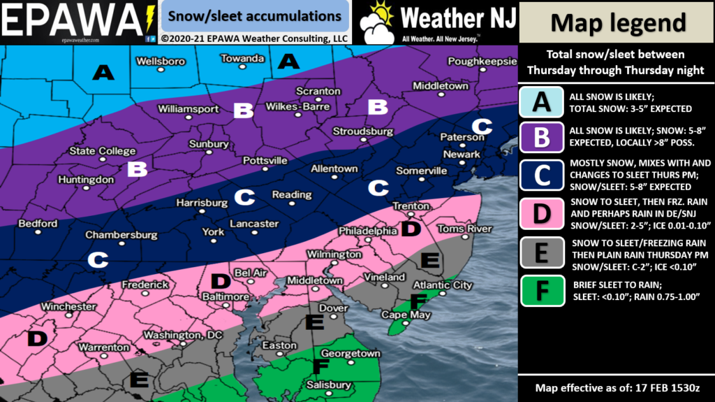
Full Resolution Snow Impact Map
Zone F should be almost an instant change to rain if it doesn’t start as rain Thursday morning. The surface will be too warm for wintry accumulation concern. Rain is expected likely for the remainder of the event.
Zone E should also see a very fast changeover to either sleet or rain with trace accumulations possible before. This zone should see mostly rain for the event. This area might change back to ending flurries.
Zone D should change over to sleet/freezing rain and eventually plain rain at times. However since the warmer areas will be pushing in from the S, this area hangs on to enough initial cold to see 2-5 inches of accumulation before the changeover. This area then sees mostly sleet, freezing rain, and rain for most of the event. Possibly trace snow accumulations to finish Friday morning when temps crash.
Zone C will likely be spared from seeing plain rain on an above freezing surface. It should see higher initial accumulations of snow and then sleet/freezing rain before ending as snow. We think 5-8 inches of a snow/sleet mix could fall in this zone.
Zone B only applies to extreme NNJ/NWNJ. This zone has the best chance to start and end as all snow with the highest accumulations of the event possible (the jackpot zone).
Additionally we’ve included a map just for ice:
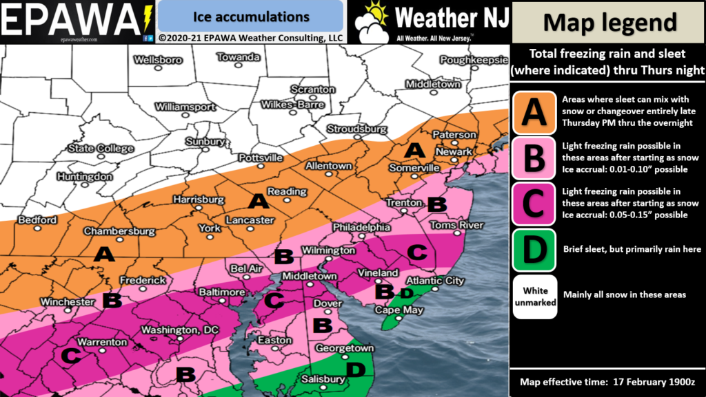
Full Resolution Ice Impact Map
In English: Snow should begin falling by sunrise tomorrow morning (Thursday). It will be approaching from the W. Snow should then spread into the rest of NJ by late-morning Thursday as snow/ice and ice/rain lines begin advancing northward through SNJ and ultimately through CNJ and into NNJ by Thursday afternoon/evening. The entire system should then turn colder again as the storm moves away Thursday night into Friday morning. This might change precipitation type back to snow for at least NENJ/WCNJ and SNJ back to at least sleet with maybe some snow mixed in. Some guidance actually extends this through much of Friday. We’re thinking a noonish stop time for now is a reasonable expectation. Extreme NWNJ should be all snow for the entire event. The above snow map illustrates our last thoughts heading into live observations. Have a great rest of your Wednesday and please be safe! JC
Jonathan Carr (JC) is the founder and sole operator of Weather NJ, New Jersey’s largest independent weather reporting agency. Since 2010, Jonathan has provided weather safety discussion and forecasting services for New Jersey and surrounding areas through the web and social media. Originally branded as Severe NJ Weather (before 2014), Weather NJ is proud to bring you accurate and responsible forecast discussion ahead of high-stakes weather scenarios that impact this great garden state of ours. All Weather. All New Jersey.™ Be safe! JC


LOCAL FORECAST | INTERACTIVE RADAR | LATEST NJ WEATHER ALERTS | WEDDING FORECAST| PRIVACY POLICY
© Copyright 2026 Weather NJ LLC. All Rights Reserved.
Some information that can be found on our website is provided by a private weather station and is not an officially recognized station for weather reporting. Though we always strive to achieve accurate reporting for our own use, it is important that you do NOT depend on the data provided here for any purpose.
