

Feb 18: Weekend Rain Detected
A low pressure disturbance will sneak between two Arctic air masses this Saturday night into Sunday. The central low pressure track will likely be just west of/along the Appalachian Mountains which traditionally spells rain for New Jersey and nearby surrounding areas. The only wintry concern is at the onset of precipitation when the ground might still be at or below freezing despite warmer mid-levels of the atmosphere. If this ends up being the case, then a period of snow, sleet and/or freezing rain is possible for NNJ and CNJ to start before going over to all rain. I suppose the upper elevations of NWNJ could squeeze out some light slushy accumulations but SNJ will likely be mostly rain throughout the entire event. Timing as of now looks like Saturday evening into Sunday afternoon.
Here is the 12Z GFS (850mb pressure, temperature and precipitation) which illustrates the westerly track during 1AM and 7AM Sunday morning:
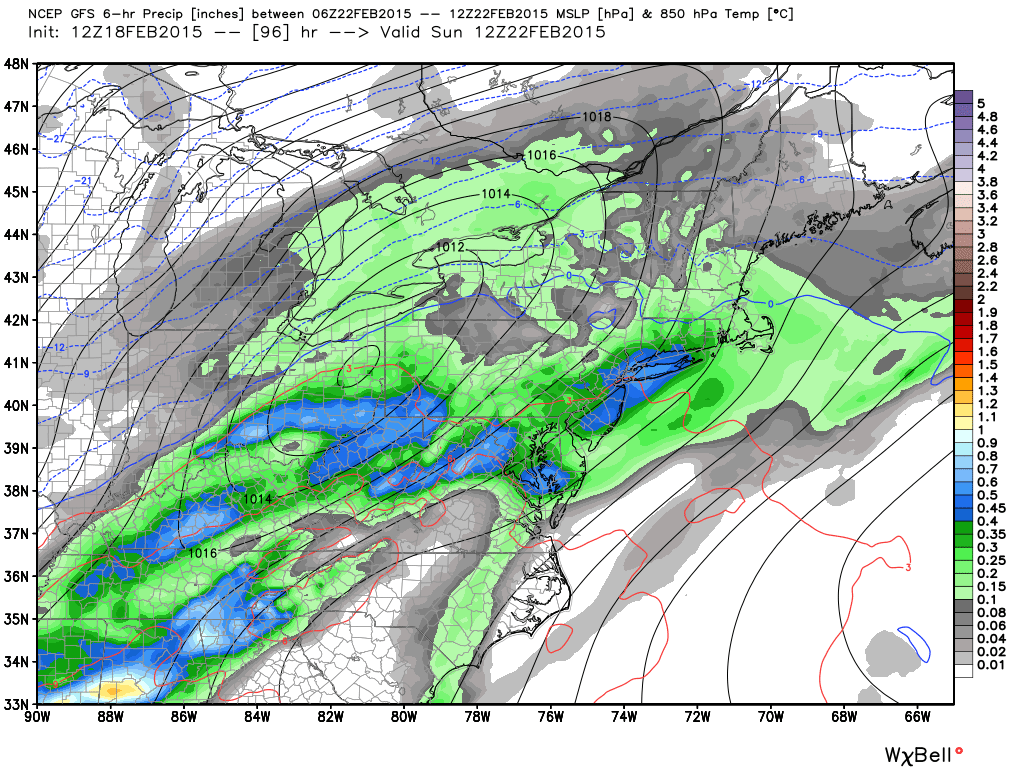
In English: It’s going to rain Saturday night into Sunday for most of New Jersey. The further north you are, the better the chance for some light wintry precipitation (snow, sleet and/or freezing rain) to start. Otherwise it should be a fairly quick changeover to rain (if it doesn’t start as rain). It will be very cold before (Thursday-Friday) and after (Sunday night into next week) this disturbance. Strong winds on the back side of the precipitation should help evaporate most rods before freezing but black ice should be at least a minor concern for Sunday night into Monday. The next threat beyond that is too far out to confidently analyze but models like an active period between February 24-28. I’ll be tracking. Be safe! JC
Jonathan Carr (JC) is the founder and sole operator of Weather NJ, New Jersey’s largest independent weather reporting agency. Since 2010, Jonathan has provided weather safety discussion and forecasting services for New Jersey and surrounding areas through the web and social media. Originally branded as Severe NJ Weather (before 2014), Weather NJ is proud to bring you accurate and responsible forecast discussion ahead of high-stakes weather scenarios that impact this great garden state of ours. All Weather. All New Jersey.™ Be safe! JC


LOCAL FORECAST | INTERACTIVE RADAR | LATEST NJ WEATHER ALERTS | WEDDING FORECAST| PRIVACY POLICY
© Copyright 2025 Weather NJ LLC. All Rights Reserved.
Some information that can be found on our website is provided by a private weather station and is not an officially recognized station for weather reporting. Though we always strive to achieve accurate reporting for our own use, it is important that you do NOT depend on the data provided here for any purpose.
