

Feb 20: Weekend Storm Update
Model guidance continues to show more of a front end snow thump tomorrow afternoon-evening before changing over to sleet/freezing rain and ultimately rain by Sunday morning. Here’s my latest impact map/update.
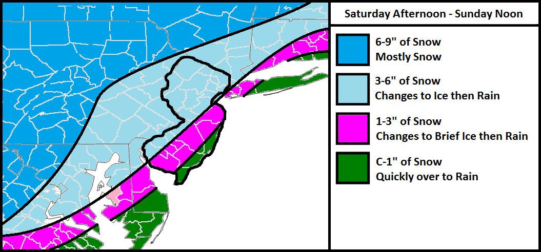
The darker blue area should stay snowy the longest and only areas in the SE half of it “should” transition to some ice/rain towards the tail end of the system. For this reason, this area has the highest expected accumulations. I expect only a small period of sleet/freezing rain during the tail-end transition.
The lighter blue area should still see a decent front-end snow thump but should feature a longer transition to rain—naturally creating a longer duration of sleet and/or freezing rain between the snow and rain.
The pink area, like the lighter blue area, should still see a decent front-end snow thump but should feature an even longer transition to rain—again naturally creating a longer duration of sleet and/or freezing rain between the snow and rain.
The green area could start with light snow but should change over to mostly rain.
Cold Air Damming (CAD) should be minimal since a departing high pressure system (the one that’s currently re-enforcing the cold) will be providing warmer southerly flow tomorrow. Also, once the low approaches, the flow will switch to the SW (parallel to the Appalachian Mountains). This will help erode the colder layers but not all of it. The surface should hold onto just enough of a temperature inversion to allow for the icy transition. Once all areas go to rain and ultimately taper off around noon on Sunday, we need NW winds to howl afternoon-evening to help evaporate any wet surfaces. Arctic air is expected to return for Monday.
In English: We’re very cold through tomorrow morning but will begin to moderate some tomorrow during the day. Expect a front end period of snow tomorrow afternoon-night followed by an icy transition overnight into Sunday. All areas should go over to rain by daybreak on Sunday with precipitation tapering off by/around noon. Should overnight models continue the colder/snowier up-front trend, I’ll make final adjustments for the final call early tomorrow afternoon. Be safe! JC
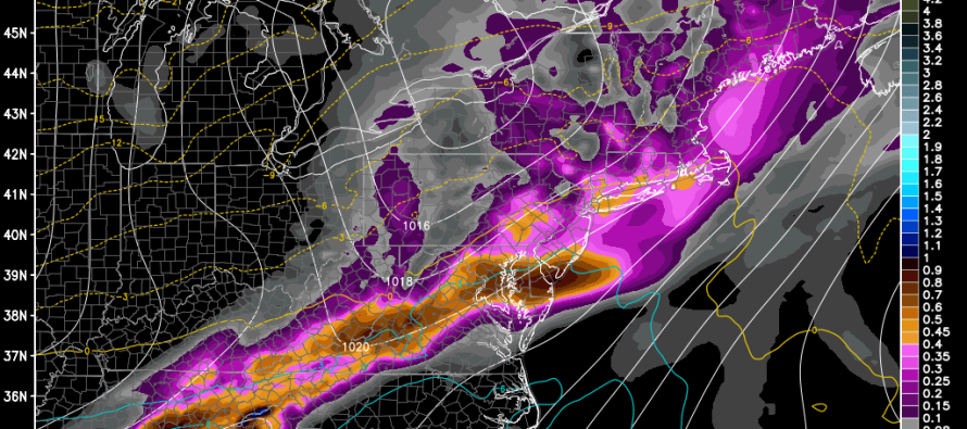
Model image used with permission from WeatherBell Analytics.
Jonathan Carr (JC) is the founder and sole operator of Weather NJ, New Jersey’s largest independent weather reporting agency. Since 2010, Jonathan has provided weather safety discussion and forecasting services for New Jersey and surrounding areas through the web and social media. Originally branded as Severe NJ Weather (before 2014), Weather NJ is proud to bring you accurate and responsible forecast discussion ahead of high-stakes weather scenarios that impact this great garden state of ours. All Weather. All New Jersey.™ Be safe! JC


LOCAL FORECAST | INTERACTIVE RADAR | LATEST NJ WEATHER ALERTS | WEDDING FORECAST| PRIVACY POLICY
© Copyright 2026 Weather NJ LLC. All Rights Reserved.
Some information that can be found on our website is provided by a private weather station and is not an officially recognized station for weather reporting. Though we always strive to achieve accurate reporting for our own use, it is important that you do NOT depend on the data provided here for any purpose.
