

Feb 21: Light Snow Event approaching NNJ
Discussion: Tonight should be another cold one. Nothing crazy record breaking but lows dropping below freezing statewide (into 20s for much of NJ). The high pressure, that drove down the decaying Arctic air mass over NJ this weekend, will pass overhead tonight into the Atlantic Ocean. Instead of cold N flow from the front of the high’s anti-cyclonic spin, we’ll then have warmer S flow from about midnight tonight through much of tomorrow.
This will drive surface temperatures well into the 40s for most of SENJ by early Monday (regardless of how cold it gets by midnight-ish Sunday night). Areas along and just SE of 95 will rise above freezing. Only areas along/N of 78 and along/W of 287 will likely stay near freezing on Monday. NWNJ elevations likely a few degrees below freezing. For that reason, this approaching system only concerns NWNJ/WCNJ for wintry accumulations on Monday.
This event comes in the form of low pressure tracking through the Great Lakes into SE Canada. The system organizes enough to form the traditional Norwegian Cyclone Model. NJ therefore sees a warm sector (high pressure S return flow hands baton to S flow ahead of cold front) leading up to a cold front passage from W to E. Typically this would be rain for all of NJ but given the potency of the current cold air mass, NWNJ and parts of WCNJ will be slower to warm with Cold Air Damming (CAD) against the EPA/NWNJ Appalachian Mountains.
Precipitation should arrive in WNJ around 10-11am on Monday and exit ENJ by 5pm. Over that period, expect a thinner area of heavy precipitation to move across NJ from W to E. It looks like a good thumping of snow for NWNJ in a short period. Areas along and just NW of 95 could start wintry but will likely change over to rain rather quick. Areas SE of 95 should still expect a period of heavy rain just ahead of the cold front. Heck you might even hear a few rumbles from thunderstorms embedded in the front.
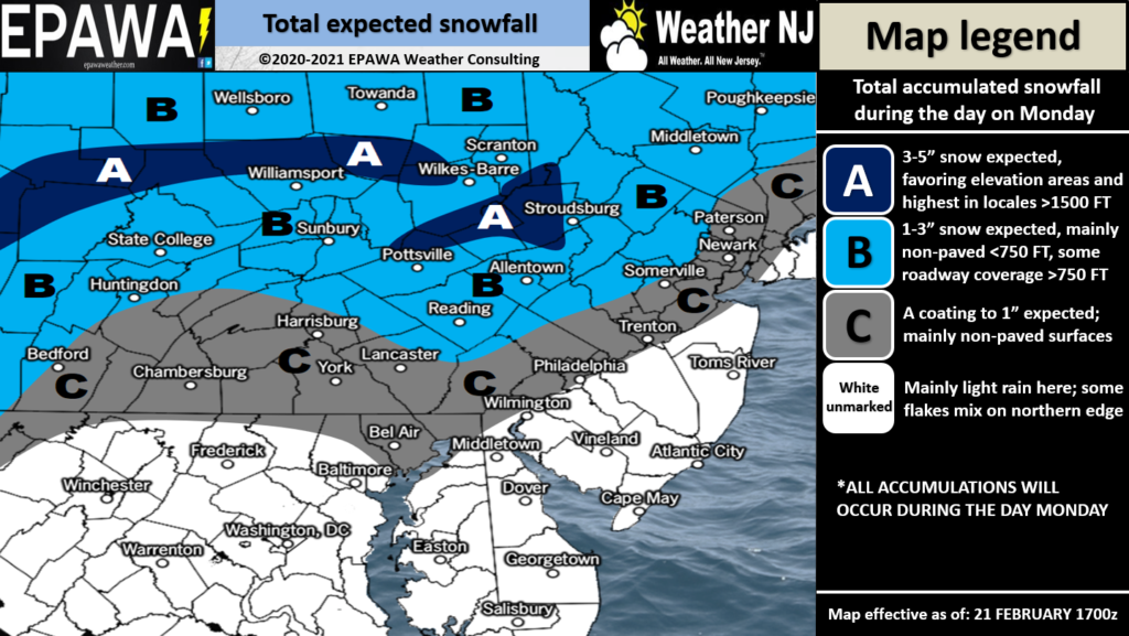
A few other safety concerns: 1) Dense Fog. Temps should drop pretty good from sunset until about midnight tonight. Warm air (above current dews in place) will then advect in from the S from midnight-ish into tomorrow. This should saturate most of SNJ before precipitation begins and spells out a fog receipt in theory. This could last right up until the precipitation arrives. 2) Anything that hasn’t dried/vaporated by midnight Monday night will likely freeze by Tuesday morning as the entire state of NJ drops below freezing, even Cape May County. So just keep that in mind. Otherwise, here’s our snow map forecast for this light wintry system:
After this, I’m still watching Friday (Feb 26) but rather unimpressed by trends on weekend data/guidance. The polar vortex split/SSWE/Arctic air is leaving the E US after today. Teleconnections are no longer favorable for supporting east coast snowstorms. The AO and NAO are now neutral to just positive. The PNA and EPO are equally mundane. We’re leaving the active winter pattern. As far as I can see (maybe through first week of March), the only available cold is stale Canadian cold (not true Arctic cold) which would most likely be transient over NJ behind FROPAS/ahead of SW flow. With that said, the only snow systems for the rest of this winter will need to be thread the needle and overnight occurrences to overcome climatology and increasing sun angle.
We’re probably just starting the 8th inning of snow season now. NNJ/CNJ are winning the game (above average snow) but most of SNJ still down a few runs (below average snow). It’s up to you if you want to leave the stadium and beat the traffic (declare winter over) but you still have 6 outs remaining over next 4 weeks or so. I think highs in the 60s might start visiting in the next two weeks, for at least SNJ. I can’t say this will mean a warmer March overall, but I honestly wouldn’t mind it.
In English: It’s going to snow in NNJ on Monday. Nothing crazy. Light accumulations (see above map) that will accumulate much easier on natural surfaces than on roads. NWNJ elevations should remain the coldest and therefore see the highest accumulations. WCNJ and NENJ could start snowy but should change to rain before anything can stack up. The rest of NJ along and SE of 95 is likely all rain with temps well into the 40s (no matter how cold it gets tonight – the warmth is coming). Arrives around 10am Monday for WNJ and departs by sundown Monday. Please be careful of Monday AM fog if traveling, especially in SNJ. Also ice is possible Tuesday morning for any rain/puddles/wet surfaces that do not dry/evaporate by late-Monday night. Not much going on wintry beyond that as the Friday Feb 26 signal is looking lame/weak. Have a great rest of your Sunday and please be safe! JC
Jonathan Carr (JC) is the founder and sole operator of Weather NJ, New Jersey’s largest independent weather reporting agency. Since 2010, Jonathan has provided weather safety discussion and forecasting services for New Jersey and surrounding areas through the web and social media. Originally branded as Severe NJ Weather (before 2014), Weather NJ is proud to bring you accurate and responsible forecast discussion ahead of high-stakes weather scenarios that impact this great garden state of ours. All Weather. All New Jersey.™ Be safe! JC


LOCAL FORECAST | INTERACTIVE RADAR | LATEST NJ WEATHER ALERTS | WEDDING FORECAST| PRIVACY POLICY
© Copyright 2026 Weather NJ LLC. All Rights Reserved.
Some information that can be found on our website is provided by a private weather station and is not an officially recognized station for weather reporting. Though we always strive to achieve accurate reporting for our own use, it is important that you do NOT depend on the data provided here for any purpose.
