

Feb 24: Tornado Watch Discussion
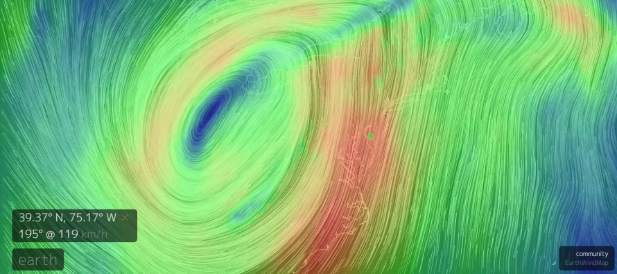
My goal with this article is to educate you as I know the atmosphere, calm you a bit and help everyone be a little safer heading into tonight. Mesoscale severe wind events are incredibly difficult to forecast but that’s what we’re dealing with from now through about midnight (from W to E). The above image represents wind speeds at the 850mb layer (just ~5,000 ft above sea level). The green dot in SWNJ is indicating S/SW wind speeds at this level of 119 kilometers per hour (about 74 miles per hour). This should actually increase some over the next few hours.
At the surface, we currently have about 15-25mph sustained winds out of the S/SE with localized gusts to 40mph. The difference in wind direction between the surface and aloft is the primary concern for this wind event. This allows for an environment favorable for at least horizontal roll between the conflicting layers of different wind direction. This is why wind shear parameters are monitored for severe weather. This further creates convective conditions (up and down-drafting). Such convective action can bring the stronger winds at the 850mb layer down to the surface which validates the concern for severe wind gusts this evening.
Should an updraft (it wouldn’t take much instability to assist) stand horizontal roll upwards enough then it could funnel down to the surface and connect as a tornado. There is likely a better chance of this to our SW in the Maryland/SEPA area. SWNJ would have the greatest risk due to being closest proximity to the strongest dynamics. The further NW in NJ you go, the lesser the chance. This is likely at least some of the reasoning behind the National Weather Service Tornado Watch issued for Mercer, Burlington, Camden, Gloucester, Salem, Cumberland, Cape May and Atlantic Counties through 11PM.
Should vertical rotation become strong enough (evident on radar velocity) and/or a trained spotter reports of such, the National Weather Service will issue a Tornado Warning. A tornado warning should be treated as a tornado on the ground as opposed to a tornado watch which simply states the favorable conditions for a tornado to form. This warning will aggregate through all sorts of emergency channels including social media, emergency push notifications, etc.
Keep in mind the strong low pressure system passing through the E Great Lakes are driving these dynamics which have already produced severe weather across the SE US. With any luck though, we’ll only deal with severe wind gusts and heavy downpours. These lines of convective precipitation and wind tend to fizzle slightly as they move E of the Delaware Rover over New Jersey. I in no way wish to downplay however, the National Weather Service’s concern. The dynamics are surely there. It’s best to play it safe just in case and learn how to be even more prepared for the next time.
In English: Heavy downpours of rain and high wind gusts are likely between now and just after midnight. Severe winds and possibly a localized tornado (higher risk in SWNJ) are possible. Here is a great tornado safety resource from the National Weather Service Storm Prediction Center. Peak intensity should occur just ahead of the cold frontal passage later this evening (between 8PM and ~midnight from WNJ to ENJ). The energy should weaken as it moves E. You can already see the primary linear segment forming on radar passing moving E through PA and MD. For now, the first few cells are starting to roll through from the south and there is already a severe thunderstorm warning in W/SWNJ. I’ll be live-casting this evening as the event unfolds. Please be safe! JC
Jonathan Carr (JC) is the founder and sole operator of Weather NJ, New Jersey’s largest independent weather reporting agency. Since 2010, Jonathan has provided weather safety discussion and forecasting services for New Jersey and surrounding areas through the web and social media. Originally branded as Severe NJ Weather (before 2014), Weather NJ is proud to bring you accurate and responsible forecast discussion ahead of high-stakes weather scenarios that impact this great garden state of ours. All Weather. All New Jersey.™ Be safe! JC


LOCAL FORECAST | INTERACTIVE RADAR | LATEST NJ WEATHER ALERTS | WEDDING FORECAST| PRIVACY POLICY
© Copyright 2026 Weather NJ LLC. All Rights Reserved.
Some information that can be found on our website is provided by a private weather station and is not an officially recognized station for weather reporting. Though we always strive to achieve accurate reporting for our own use, it is important that you do NOT depend on the data provided here for any purpose.
