

Feb 26: Light Snow Targeting NNJ

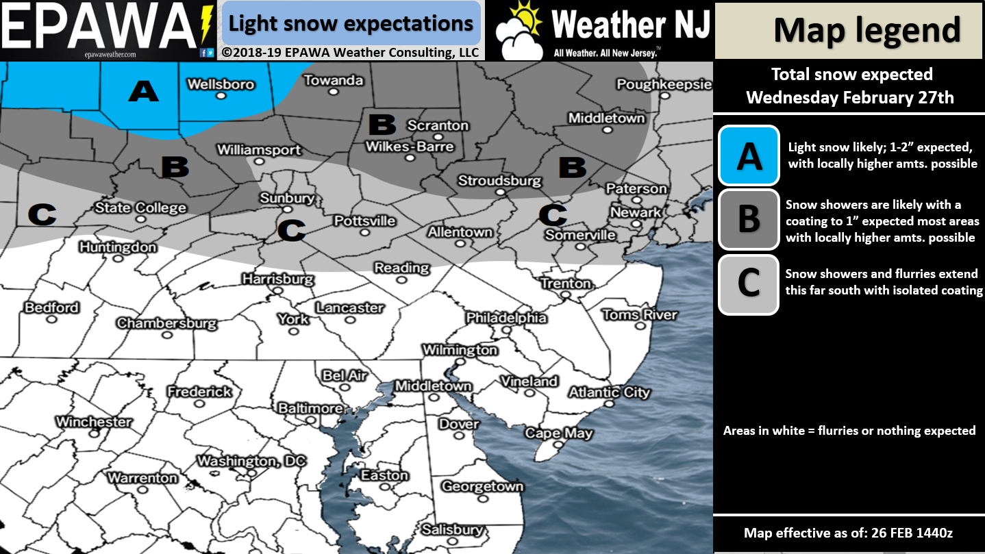
Click here for full-resolution snow map!
Discussion: From the upper-levels, there’s nothing to write home about. We have a very flat and zonal flow across the US and therefore tomorrow’s disturbance will be a quick mover. There should be two waves of precipitation. The first should be the weaker of the two during Wednesday AM hours. The second should be a more concentrated batch of precipitation during Wednesday PM hours. A lull in precipitation between waves is expected for NNJ between late-morning and either late-afternoon or early evening tomorrow. Not much of anything should happen S of I-78. Only I-80 and northward have the best chance to see light accumulations.
The near-future is uncertain but it appears winter is trying to rally in the 9th inning. We’re watching another weaker wintry wave for this weekend (for more of NJ than just NNJ) and then something possibly bigger for early next week. The general period from now until about March 12 is currently modeled as winter’s last hurrah with a favorable MJO phase and high-latitude blocking. As per usual this year it’s all going to come down to the timing of the cold, precipitation and upper-level energy.
After March 12 the MJO should head into a warmer phase (for the E US) and we might actually enjoy some spring time in March. Imagine that! There are always cold waves possible through March and April (even sometimes May) but we might be finished with the brutal cold and snow after that March 12 target. Tomorrow’s NNJ wave is straight-forward but this weekend and next week require more analysis as the data funnels into agreement hopefully by Thursday/Friday.
In English: First off, the white area on our snow map does not represent snow. It represents nothing. The title and discussion of this article is clear in suggesting that the wintry threat for tomorrow is confined to NNJ only. With that said light snow is possible tomorrow for NNJ in two waves. First during morning hours and then during afternoon/evening hours. This is not a big deal. The bigger deal is how March 1-12 is starting to look. More snow is possible this weekend and then possibly a larger plowable event early next week. I will be tracking these possibilities closely and will hopefully have something more confident out by Thursday evening. Download the new free Weather NJ mobile app on Apple and/or Android. It’s the easiest way to never miss Weather NJ content. Our premium services go even further above and beyond at the hyperlocal level. Have a great rest of your Tuesday and please be safe! JC
Jonathan Carr (JC) is the founder and sole operator of Weather NJ, New Jersey’s largest independent weather reporting agency. Since 2010, Jonathan has provided weather safety discussion and forecasting services for New Jersey and surrounding areas through the web and social media. Originally branded as Severe NJ Weather (before 2014), Weather NJ is proud to bring you accurate and responsible forecast discussion ahead of high-stakes weather scenarios that impact this great garden state of ours. All Weather. All New Jersey.™ Be safe! JC


LOCAL FORECAST | INTERACTIVE RADAR | LATEST NJ WEATHER ALERTS | WEDDING FORECAST| PRIVACY POLICY
© Copyright 2025 Weather NJ LLC. All Rights Reserved.
Some information that can be found on our website is provided by a private weather station and is not an officially recognized station for weather reporting. Though we always strive to achieve accurate reporting for our own use, it is important that you do NOT depend on the data provided here for any purpose.
