

Feb 4: Arctic Front + Ocean Effect + Overrunning = Potential for Snow Beginning Sunday!
Im going to say this right off the bat. IT IS NOT GOING TO SNOW FOR 120 HOURS STRAIGHT! Lets be clear on this. Yes it will snow beginning early Sunday morning and it appears that we may be in for a rather long stretch of snow that could last into the middle of next week. But I have never seen it snow straight through for 5 days. There will be breaks in this. They may not last long. But there will be breaks!
Okay lets discuss a few things with regards to storms. Both weak and small there are a lot of variables that come into play. You dont have to see a giant L on a map with a lot of circles drawn around it to get heavy precipitation. Sometimes all you really need is for a few things to come together and the outcome can be a fairly sizable snowfall.
This seems to be what is setting up for the areas from New Jersey and Pennsylvania northward into Southern New England and everyone in between. Once the next arctic air mass moves offshore Saturday we await the arrival of another arctic front that will settle to our south. These sorts of things usually happen further north but the strength of the polar vortex in Eastern Canada that has been just sitting there is exerting its influence further south than normal.
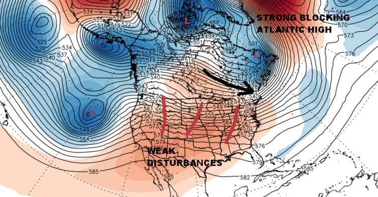
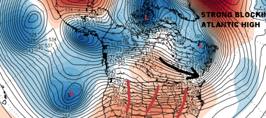
The other factor here is that there is a big blocking high pressure system aloft in the northeast Atlantic east of Greenland. It is basically holding everything in place. It is just strong enough to allow cold air to press southward at least into Southern New Jersey and Southeast Pennsylvania. More importantly it isn’t going anywhere. If you look at it closely you can see how it is sandwiched in and can’t really move. So as long as that remains the case the flow across North America remains unchanged. Now over the U.S there are several weak disturbances that are moving along in the flow, one after another.
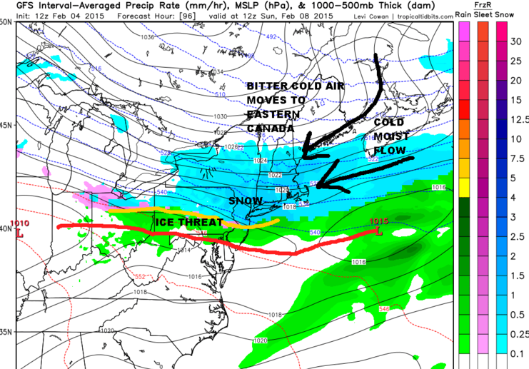
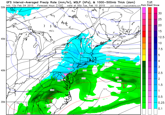
The map above is for Sunday morning. There are no big features but what you do have is a strong flow of cold moist air off the ocean. The fetch from the northeast goes out pretty far! The warm frontal boundary settles across the Delmarva Peninsula back into Northern West Virginia. You can see also a weak low in central Illinois. That boundary holds firm or sinks a little further south with time as each wave moves by. The result is overrunning. While you don’t have an intense storm you have such good inflow of moisture that it will just snow. In a way we can call it ocean effect only it is a bit more expanded in size.
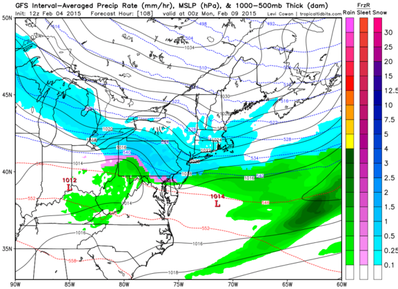
Now lets jump ahead to Sunday night 7pm and then Monday night 7PM. Still going. However now the model focuses its attention on one of these waves as you see it in southern North Carolina. Pressures there fall. The cold high is beginning to move east however there is lots of cold air damming down into the Appalachians. That low winds up moving east and eventually (because it has to) the precipitation ends.
LET ME EMPHASIZE RIGHT NOW. THERE ARE A LOT OF UNKNOWNS HERE WITH REGARDS TO THE COLDNESS OF THE ATMOSPHERE. So to make specific forecasts for areas on the southern end of the snow/ice /rain border is foolish. As we just saw here a few days ago when you have bitter cold air close by to tap, it does not take much to drain it southward. Places like Southern most New Jersey, Southern Pennsylvania and Delmarva, even down to Baltimore and Washington might see their temperatures drop much lower then models forecast because of cold air draining. Remember also we have a very deep snow pack north of 40 N into New England which is going to play a role here as well.
As far as snow potential is concerned, this could be a slow and steady grind. I do believe there will be breaks in between. I can’t imagine it snowing here 4 days straight through. It seems a little much in my view. But you could see a couple of long periods where each wave produces say 3 to 6 inches for somebody as it goes by. And with regards to the final low, this model has always had issue lifting things up the coast so I would wait to see what the European and Canadian do with this. Makes for fascinating times ahead. Keep shovels handy.
At this point comes the shameless plug to like and share my facebook page! Thank you
In English: Sunday through Tuesday has strong model agreement for a period of prolonged on-and-off snowfall.
Jonathan Carr (JC) is the founder and sole operator of Weather NJ, New Jersey’s largest independent weather reporting agency. Since 2010, Jonathan has provided weather safety discussion and forecasting services for New Jersey and surrounding areas through the web and social media. Originally branded as Severe NJ Weather (before 2014), Weather NJ is proud to bring you accurate and responsible forecast discussion ahead of high-stakes weather scenarios that impact this great garden state of ours. All Weather. All New Jersey.™ Be safe! JC


LOCAL FORECAST | INTERACTIVE RADAR | LATEST NJ WEATHER ALERTS | WEDDING FORECAST| PRIVACY POLICY
© Copyright 2026 Weather NJ LLC. All Rights Reserved.
Some information that can be found on our website is provided by a private weather station and is not an officially recognized station for weather reporting. Though we always strive to achieve accurate reporting for our own use, it is important that you do NOT depend on the data provided here for any purpose.
