

Feb 5: NNJ Ice Storm Update
Discussion: It’s been a somewhat colder day than the past few. The boundary has been pulled southward over NNJ from the back-side cyclonic flow of the weak wave that just departed. NNJ is already down into the 30s and some of the precip ended with a wintry mix today. NENJ, CNJ and SNJ remain near-40 or in the low-40s. Temperatures should gradually drop this evening with the lull in precipitation. Precipitation should then build back in around midnight-ish and drop a decent amount of liquid out of the sky between tonight and Friday morning.
NNJ folks monitor your surface temperatures tonight and early tomorrow morning if you have to travel during those times. If you sink to freezing or just below-freezing then you’re at risk for either sleet accumulation or freezing rain ice accrual. We believe the boundary will sink to about I-80 which would put areas N of I-80 and NW of I-287 at the highest risk for slippery travel conditions. The good news it that the boundary returns northward tomorrow morning JUST-before the primary am rush hour commute. So the hours of slippery travel risk are primarily between about midnight tonight and 6am tomorrow morning. I would like to note that higher elevations of NWNJ could hang onto near-freezing/just-below freezing temperatures possibly beyond 6am tomorrow morning. Even once temps come above freezing it could be 1-2 hours before any ice accrual melts. For everywhere else in NJ S of I-80 and SE of I-287 (NENJ, CNJ and SNJ) you are likely looking at plain rain only with well-above freezing surface temperatures. Areas closer to the boundary (between I-78 and I-80) might start off with some wintry mixing but will be first to warm around or by 4-6am.
Once all areas warm above freezing rain is the primary expectation through most of tomorrow into Friday. SNJ/SENJ is favored for the most amount of rainfall. The following maps represent our latest thoughts on impact. The sleet and freezing rain (ice) maps are only for the ice event late-tonight through tomorrow morning. The rain map is through Friday.
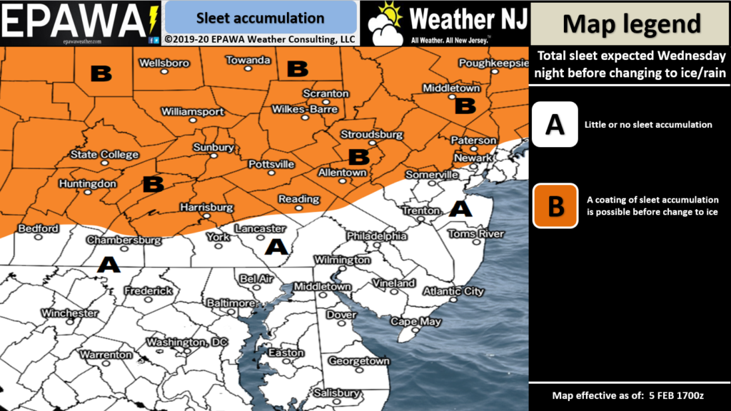
Click here to view full-resolution sleet impact map!
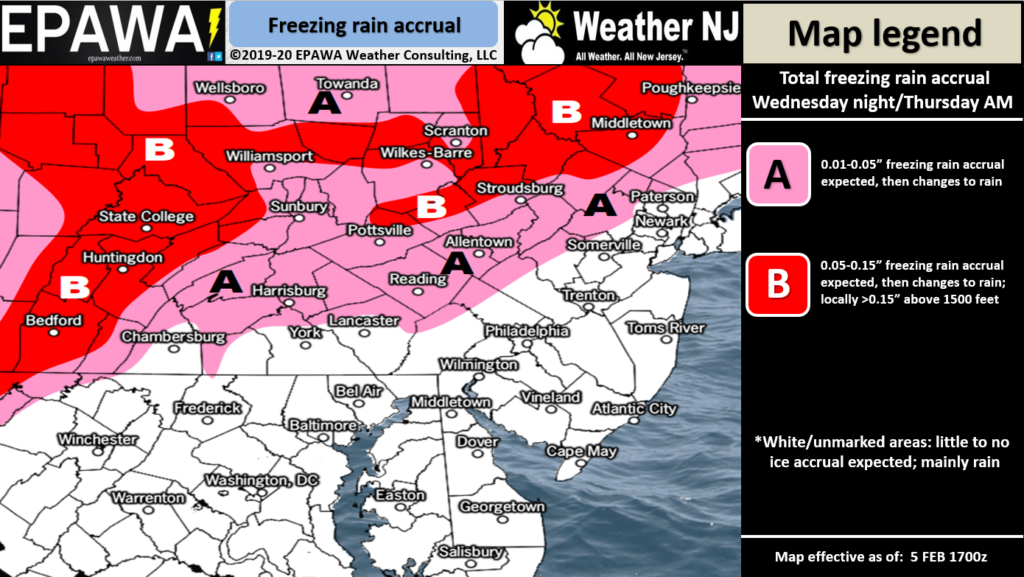
Click here to view full-resolution ice impact map!
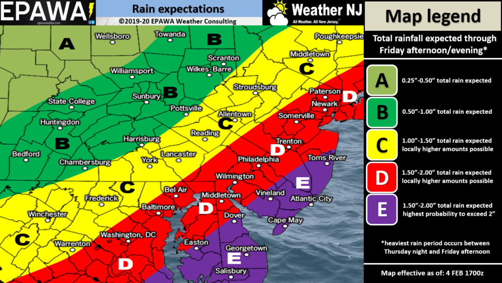
Click here to view full-resolution rain impact map!
As precipitation ends Friday there’s a small chance of flurries or snow showers but nothing that would warrant a snow map. Back-end snow rarely works out however this system is going to be amped up once it hits northern New England. Therefore it’s going to rip the boundary back down over most of New Jersey. So I wouldn’t be surprised to see such flurries and snow showers Friday. The boundary then stays to the S and SE of NJ through Saturday and into Sunday. I’m still watching Sunday for a light snow event (anything from just snow showers to light accumulations). I should be able to speak more confidently to it tomorrow and Friday. We’ll issue a snow map if needed but for now it’s not looking like a major snow event.
In English: NNJ is still favored for an icing event late-tonight through tomorrow morning. Please see the above sleet and ice maps if you are located N of I-80 and NW of I-287. Tomorrow everyone turns to rain that should persist into Friday. Everything might end as flurries and snow showers Friday but likely only for NWNJ and with little-to-no snow accumulation likely. We’re then cold for the weekend as we continue to track a light snow event Sunday. Will report more on that tomorrow and Friday. Have a great rest of your Wednesday and please be safe! JC
Download the new free Weather NJ mobile app on Apple and/or Android. It’s the easiest way to never miss Weather NJ content. Our premium services go even further above and beyond at the hyper-local level. Looking for industrial-caliber long-range forecasting data that I personally recommend? Check out WeatherTrends360! Visit the Weather NJ Kaboom Shop for hoodies, tees and infant onesies.
Jonathan Carr (JC) is the founder and sole operator of Weather NJ, New Jersey’s largest independent weather reporting agency. Since 2010, Jonathan has provided weather safety discussion and forecasting services for New Jersey and surrounding areas through the web and social media. Originally branded as Severe NJ Weather (before 2014), Weather NJ is proud to bring you accurate and responsible forecast discussion ahead of high-stakes weather scenarios that impact this great garden state of ours. All Weather. All New Jersey.™ Be safe! JC


LOCAL FORECAST | INTERACTIVE RADAR | LATEST NJ WEATHER ALERTS | WEDDING FORECAST| PRIVACY POLICY
© Copyright 2026 Weather NJ LLC. All Rights Reserved.
Some information that can be found on our website is provided by a private weather station and is not an officially recognized station for weather reporting. Though we always strive to achieve accurate reporting for our own use, it is important that you do NOT depend on the data provided here for any purpose.
