

Feb 6: Wednesday Final Call and Snow/Ice Maps
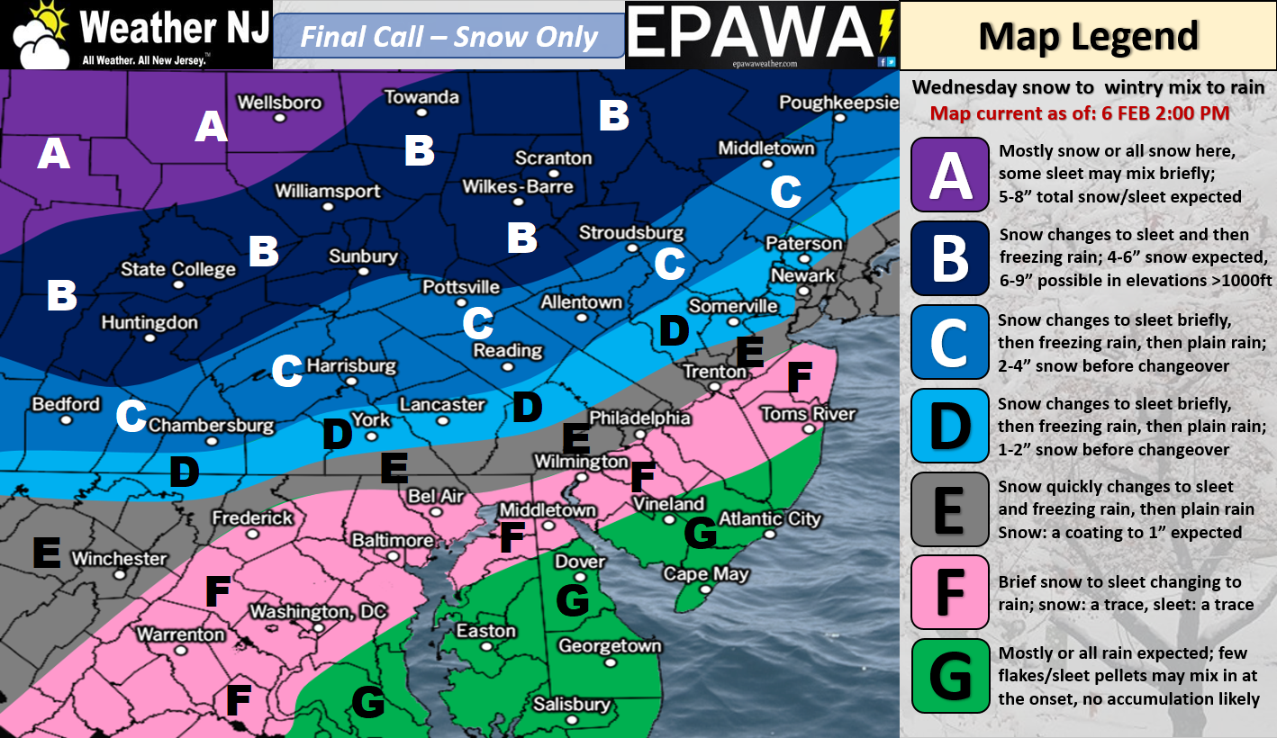
Click here for full-resolution snow map!
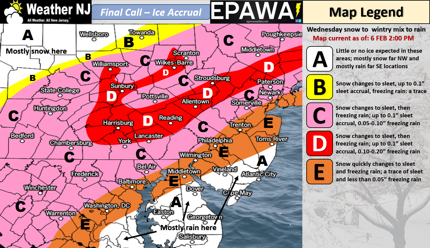
Click here for full-resolution ice map!
Discussion: A wintry disturbance is approaching from W/SW. If you draw a line from West Virginia through SEPA and NYC into the Boston area, that’s where the low pressure center should track between tomorrow (Wednesday) and Thursday. We’re dealing with multiple forms of impact with this system so the best thing to do is break it down as follows:
Front-end thump: Initial precipitation should arrive tomorrow morning well out-front and ahead of the low. Since the ground and critical atmospheric levels will be cold enough, snowfall is expected to start. Our top map above illustrates our expected snow totals for this portion of impact (sunrise through late-morning tomorrow). Parts C and D on the snow map are the most favored for accumulating snowfall. Parts C and D are also the most-likely to over-perform should snow ratios be a bit higher and/or due to elevation/earlier start/etc. Our expected totals are evidence-based estimations based on the latest data but those totals (Sussex/Warren County area) could end up being a tad low. Let’s go with 3-6″ for zone C and 2-4″ for the northern part of zone D (worst case scenario). Otherwise, this is not a major snowfall and only represents the first part of the event.
Icy transition: The low-mid levels of the atmosphere are going to start cold for the front-end snowy thump. Warm Air Advection (WAA) however will eventually make it’s way in from the south due to the leading cyclonic flow ahead of the low. This should force a layer of above-freezing air northward over ground that’s still at or below freezing. Therefore the shallow warm layer will likely melt snow into sleet or plain rain before hitting the frozen surface This is a recipe for travel disaster especially N of I-195/NW of I-95. If the warmer layer is shallow then more sleet will be present. If the warmer layer is deeper then more freezing rain will occur. The latter is the more dangerous for roads IMO. NNJ is most favored for ice. CNJ should see lesser ice impact but still possibly hazardous for travel. SNJ is the least favored for such and will likely transition to plain rain quicker than NNJ and CNJ do. This part of the event should happen between mid-to-late morning and early afternoon hours.
Ending rainfall: Eventually all of NJ is expected to change over to plain rain. There’s not much to say about this other than an expected .5″ to 1.25″ of statewide rainfall to fall between afternoon and evening hours tomorrow. Rain should end from W to E between 5-8PM for NJ.
Rapid freeze after: Assuming rainfall shuts off around 8PM tomorrow night, temperatures are expected to fall to freezing or below-freezing by 2-3AM. We should have “some” wind to help evaporate the surface but anything that does not evaporate will likely freeze by sunrise. We’ll have to play this part of the event by ear but just know that the Thursday AM commute could be affected by this especially unsalted roads.
In English: Tomorrow morning’s rush hour commute could be dicey, especially for those along and N of I-195/NW of I-95. My best advice is to not drive anywhere until your surface is above freezing. This should be mid-to-late morning for SNJ (Ocean and Monmouth – points south of such likely okay tomorrow), late-morning for CNJ, noon for NENJ and lastly early-to-mid afternoon for NWNJ. School districts and other similar interests monitoring this event should be pro-active not re-active to this. The snow is not a big deal nor is the finishing rainfall statewide. The icy transition between however should be taken seriously re: hazardous road conditions. This is a snow to ice to rain situation with NNJ/CNJ favored for highest impact and SNJ favored for the least impact. Our above maps illustrate both our snow and ice expectations. Have a great night and please be safe! JC
For comprehensive and interactive hyper-local analysis that goes way above and beyond the detail of this public forecast, check out our premium services which include text notifications and forum access.
Jonathan Carr (JC) is the founder and sole operator of Weather NJ, New Jersey’s largest independent weather reporting agency. Since 2010, Jonathan has provided weather safety discussion and forecasting services for New Jersey and surrounding areas through the web and social media. Originally branded as Severe NJ Weather (before 2014), Weather NJ is proud to bring you accurate and responsible forecast discussion ahead of high-stakes weather scenarios that impact this great garden state of ours. All Weather. All New Jersey.™ Be safe! JC


LOCAL FORECAST | INTERACTIVE RADAR | LATEST NJ WEATHER ALERTS | WEDDING FORECAST| PRIVACY POLICY
© Copyright 2026 Weather NJ LLC. All Rights Reserved.
Some information that can be found on our website is provided by a private weather station and is not an officially recognized station for weather reporting. Though we always strive to achieve accurate reporting for our own use, it is important that you do NOT depend on the data provided here for any purpose.
